|
| The Mori-no-kawa Spring |
View Map It! Okinawa in a larger map
 |
| "Mori-no-kawa, Ginowan City" |
GPS
| Latitude | Longitude |
| N 26 16.260 | E 127 44.453 |
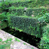
Morinokawa 森川, The Forest River Spring
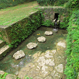
Okinawa is full of natural springs. But in Ginowan City there is one source of water that has a 'heavenly' story behind it and the makings of a once great king. Welcome to Morinokawa (Mori-no-kawa 森川), the Forest River Spring.
The Legend of Hagoromo. It is said that long ago a farmer by the name of Ufuya Okuma was on his way home when he decided to stop by the Mori-no-kawa Spring. To his astonishment he discovered a very beautiful woman (an angel) bathing in the water and not too far, was her celestial robe (hagoromo) hanging on a tree. The farmer then took her heavenly garb and when the angel discovered her robe had mysteriously vanished she went into a panic – for she could not return to the heavens without it. Conveniently and seemingly out of nowhere, Ufuya came to the aid of the distressed woman, clothed her, and took her in. His ploy had worked! With no home to return to, she became the farmer's wife and would later give birth to two children, a boy and a girl.
Legend has it that, '...one day the angel heard her little daughter singing a lullaby, “Don't cry baby. Toubins-hanin's (angel's wings) are hidden in the storehouse under the millet. Don't cry baby.” The angel rushed to the storehouse and sure enough, there she found her hidden robe.'(1)
Upon her discovery, the angel left to the heavens, never to return.
Her Children's Fate. What became of her daughter is not really certain at this time,...but legend has it that the son grew up and became a great king. He is none other than King Satto, a once great king of the Chuzan region, the central area of the Ryukyu Kingdom during the 14th Century.(2)
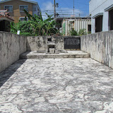
Epilogue. The Mori-no-kawa Spring is part of the a much larger park and there, you may see artwork of a celestial being. This represents the angel in the story. Also near the spring, you will see a monument in the form of a gate. This gate was first constructed in 1725 by the Ie Family in honor of the Legend of Hagoromo.(3)
Source of Information/Citation. 1. Legend of Hagoromo/King Satto, Pg 107, Okinawa Tourism Guide Book Revised Edition 1998, Published by the Bank of the Ryukyus International Foundation 2. King Satto's reign, Pg 62, Okinawa: The History of an Island People, George Kerr 3. Monument information, explanation sign on site, Japanese only).
Author's Note. The Okinawa Tourism Guide Book, Revised Edition 1998, uses the term “toubinsu” meaning a feathery robe and “toubins-hanin's meaning “angel's wings”. These are believed to be from the Okinawa language, but cannot be independently verified at the moment. Hagoromo is Japanese meaning an angel's garment.
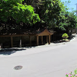
Directions. Take Highway 58 into Ginowan City (not the 58 by-pass). You will see major signs both in English and in Japanese along Highway 58 directing you to the Mori-no-kawa Park. Once you make the turn from Highway 58 the road continues straight and then makes a bend to the right. Look for these arches on the left side of the road. As soon as the arch ends will be the entrance to the park. If you are going to fast the entrance will sneak up on you.