Search Map It! Okinawa

Wednesday, August 29, 2012

"The Nanjo Sunrise and Cape Chinen"

Sunrise at Cape Chinen


View Map It! Okinawa in a larger map
The Nanjo Sunrise and Cape Chinen

     GPS
     LatitudeLongitude
     N 26 10.009E 127 49.790


The Nanjo Sunrise and Cape Chinen


If you are an early, early morning person and don't mind a little road trip to the southern portion of Okinawa, then a sunrise to start off your day might not be a bad way to begin your sight seeing adventure. The picture you see above was taken from Cape Chinen (Chinen Misaki) in Nanjo City just after sunrise. The chrome sculpture in the foreground adds a nice touch against the early morning rays, and as with most sunrises, you will capture the varying transitioning colors as the sun ascends into the morning sky. From Cape Chinen, both Kudaka and Komaka Jima can be seen in the immediate background, and if you are planning a day trip to either island, then making a sunrise as your first checklist item wouldn't be a bad way to kick things off.

But still, if you are not an early riser, a short break at Cape Chinen during one of your road trips is highly recommended. See photo album above or click here to see other photos of Cape Chinen during the day.

Directions. The turn-off to Cape Chinen is just off Highway 331. You will see a large visible sign on the Highway 331 pointing you in the direction. See LandMark above. Collocated at the turn-off is the Nanjo City Information Center that may provide other information of local attractions in the area.

Other places of interest nearby. Kudaka Jima, Azama Port, Komaka Jima.

Wednesday, August 22, 2012

"Sesoko Beach"

Sesoko Beach


View Map It! Okinawa in a larger map
Sesoko Beach

     GPS
     LatitudeLongitude
     N 26 38.895E 127 51.299


Sesoko Beach, Motobu Town


Sesoko Beach is not like any other beach you will find here on Okinawa. It offers a good variety of small scenic adventures and recreational activities on this very quiet but beautiful island of Sesoko. The beach stretches to about 650 meters with the bookends surrounded by jagged coral cliffs with small caves embedded in the them. At some points it feels like being in a maze as you navigate up and down the shore. Low tide offers you the chance to venture out little further to take a peek to see what's around the corner. In the background, you will see a small flat island called Minna Jima, and further north a much larger island, Ie Shima, which at glance appears to have a 'Mt. Fuji' like mountain* in the middle. Sesoko Beach is a very beautiful beach surrounded by very beautiful natural landscape. It is a great place to visit and relax throughout the year.

The future of Sesoko Beach. It appears that a large resort facility adjacent to the beach is under construction, but whether it comes to fruition is uncertain. As of right now, Sesoko Beach does not appear to be marred by large over populated towns. For the most part, the surrounding landscape is still preserved in its natural form which makes Sesoko Beach all the more special.

* The mountain-like hill on Ie Shima is called Mt. Gusuku.

Posted Beach Rules.
1. Swim in patrolled areas only.
2. Beach hours
    July to September 9:00AM - 5:30PM
    April to June and October 9:00AM - 5:00PM
3. Do not enter the water if you have been consuming alcohol.
4. Watch your children! All children must have an adult in close proximity at all times.
5. Beaches are staffed by lifeguards only during posted hours. Beach use it at individual's own risk.
6. Keep your beach clean and safe.

Author's note. Certain facilities/rules may or may not be available/apply during the non-tourist season. Some of the items below were not visible during the fall and winter season. Plan accordingly. Sesoko Beach will be revisited to see if changes to facilities have been made. It appeared that upgrades were being made to the facilities at the time of this post. Changes may occur in the near future.

Swim nets. Swim nets were visible during the summer tourist season. However, they were not visible during the fall and winter season. Swim at your own risk.
Rentals. During tourist season recreational equipment (beach umbrella etc.) can be rented out. Not seen during the fall and winter season.
Food Stands. Small food stands were only visible during tourist season.
Restroom. Special toilet facilities were visible during the tourist season, however not visible in the fall and winter season.

Parking. During tourist season, they do not allow you to park nearby on the street-side. They have a designated parking lot. At the time of this post, parking cost was 1000 Yen. You can park for free further up the road but it will be at a good distance to the beach. When visiting during the fall and winter season, the lot was closed and parking was allowed on the street-side. Park at your own risk.

Directions. Take Highway 172 from Highway 449 in Motobu. Once you get on the 172 you will cross the Sesoko Bridge. Follow Highway 172 to the designated LandMark (radio/cell tower). The radio/cell tower will be on the left just past the intersection you are supposed to turn right on. This is where the designated Blue Route begins. If you drive straight along the Blue Route, you will end up at Sesoko Beach.

Other places to visit nearby. Toto la Bebe Hamburger

Tuesday, August 14, 2012

"Komaka Jima, Nanjo City"

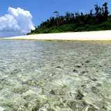
On top of a coral ledge


View Map It! Okinawa in a larger map
Komaka Jima

     GPS *
     LatitudeLongitude
     N 26 10.501E 127 49.792

       * GPS is to the Chinen Leisure Center


Komaka Jima, Nanjo City


If you are looking for a one day getaway, then a quick trip to a little island may satisfy your appetite. Several kilometers east of the Chinen Peninsula lies this tiny island paradise known as Komaka Jima (コマカ 島). It's roughly a 300 by 300 square meter island, with plenty to do and see during your stay. Most who venture here go for the clear ocean water and fun in the sun. But if you just want to relax and leave the rest of the world behind for a few hours then this is a great place for it as well. If you like taking photographs, you will have plenty of opportunity to take shots of unique features around the island. Please click here or click on photo album above to see other angles of Komaka Jima. If you are into birding, the Terns here during the summer will keep you busy. Get too close, and they will let you know, as this bird did diving towards the camera. From a distance, you will see Kudaka Jima to the northeast. Get out and see another island! Visit Komaka Jima.

TRAVEL INFORMATION (Important! Please Read Before you go!).
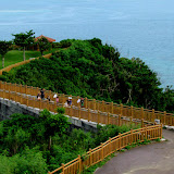
Departure Point. Your trip begins at the Chinen Leisure Center just a few hundred meters south of the Azama Port and the San-San Beach along Highway 331. The entrance way is marked by this gate with two dolphin statues at each end. The port is down at the bottom. The GPS coordinate above is to the Leisure Center. See map above to see ticket office location (next to the boat port). The boat ride is about 15 minutes one way.

Getting Your Ticket. You will see various buildings as you make your way down to the small port. The ticket office will be a small shack (see photo) down at the very bottom next to the boat port. Here you purchase your ticket (make sure you keep your ticket stub till you return!!!!). The staff will ask you what time you would like to leave and return and will annotate this on your ticket stub.

Your Return Time. When you purchase your ticket you have to tell them what time you would like to return in advance. If for some reason you would like to leave earlier or later than your original request, please let the staff know on Komaka Jima at least 30 minutes in advance.

Ticket Prices. At the time of this post, round trip ticket prices were 2500 Yen per adult and 1250 Yen per child.

Weather Cancellation. If the seas are rough (even on a beautiful day), then all boat trips to Komaka may be canceled for safety reasons. This has to do with the size of the boats, water safety, and off-loading passengers safely on Komaka. It is highly advisable that you have a back-up plan should you arrive and trips are canceled. Cancellations may occur without notice. Please look at the weather report or call in advance. Cancellation may only last for hours of the day depending on the sea conditions. Possible back-up plans: There is the Azama San-San beach adjacent to the port if you still want to hit the beach or you can take a trip to Kudaka Jima from Azama port on the much larger boats. See articles on Azama Port and Kudaka Jima for more information.

Depature Times. Boats leaves the Chinen Leisure Center every 30 Minutes beginning at 915. Next one is 945 and so forth with the last boat leaving at 1645.

Return Times. Return times is also every half hour starting from 10am next one 1030am etc with the last boat leaving 1730 form Komaka Jima.

Water Safety Regulations. As pertaining to Komaka Jima, the Japanese Coast Guard requires that individuals who wish to swim or snorkel on or near the island MUST wear a life jacket or some floatation device. You can rent life jackets (500 Yen all day) at any of the various rental shops near the boat port.

Rentals. Aside from the Life Jacket, you can rent out beach umbrellas (500 Yen all day) and fishing gear as well. You can also bring your own tent or umbrella for shade.

Staff Availability. There will be staff members on site at Komaka Jima should you need any assistance.

Toilet Facilities. Toilet facilities are available on island.

Shower Facilities. Upon your return, you can use shower facilities at some of the rental shops for 200-300 Yen depending on the season.

What to Bring. If you are going to be there for a long time, bring some shade (beach umbrella – can also be rented), small tent, Sun lotion for protection, plenty of water (there are no soda machines available), small cooler, bring your own snacks and meals, appropriate clothing. Consider bringing shoes. You do not want to explore and climb the rocks in sandals!

Other Recreational Activities. There are other recreational activities such as banana boat rides, glass boat rides, diving adventures that can be arranged at the ticket office. Prices are separate from the trip ticket. See link for other activities http://chinenmarine.co.jp/ryoukinhyou.htm. Google Translation maybe be required to understand the price chart.

Websitehttp://chinenmarine.co.jp (Japanese only)
Phone Number. 098 948 3355
English Language. Spoken English is very limited.
Directions. See the Departure Point at the top for navigation information.

Author's note: Komaka Jima is sometimes spelled Kumaka Jima in Japanese. 

Sunday, August 12, 2012

"Food Adventures – Toto la Bebe Hamburger"

A Toto la Bebe Avocado Cheese Burger


View Map It! Okinawa in a larger map
Toto la Bebe

     GPS
     LatitudeLongitude
     N 26 37.782E 127 53.255


Toto la Bebe, Motobu Town


When you are out and about on a beautiful Okinawan day exploring the outskirts of the Motobu Peninsula, try an eating adventure at Toto la Bebe Hamburger. By the photo you can tell they don't specialize in Okinawa cuisine. It's a Hamburger joint with an Okinawan touch. The picture above is their Avocado Cheese Burger with their special homemade bacon smoked from Cherry Trees, dices of avocado, and a touch of wasabi. But no picture can truly capture the mouth watering taste of a juicy, succulent burger. On your next exploration out in Motobu, take a pit stop at Toto la Bebe. The atmosphere is very cozy and the staff very, very friendly. Spoken English is limited, but that won't prevent your taste buds from having a 'heavenly time'.

Menu. Their menu is simple. They have five delicious burgers you can choose from, along with an assortment of deserts and drinks. They do have a menu all in English. See photo of their menu selection.

Price Range. You will spend anywhere from 680 Yen to 1000 Yen for the burger to include a side of homemade french fries. Drinks and sweets range from 300 Yen to 660, however if included in the meal the sweets and drinks come at a discount. See photo of menu for price ranges.

Parking. There is parking immediately to the front of the building or at a exclusive lot about 75 meters away. See Green Thumbtacks in the map above.

Hours of Operation. 11am-6pm. Closed Wednesdays and Thursdays.
Phone Number. 098-047-5400
Websitehttp://totolabebe.ti-da.net/
Currency. Yen Only. Credit Card system not yet available.

Directions. Toto la Bebe sits close to Highway 449 in a small town called Sakimotobu just a few kilometers south of the Sesoko Bridge. However, to get access to the restaurant, you have to enter at the designated Landmarks in the map above. There are two Landmarks. The first one (photo not available) is a street sign on the 449 that points to the 'Sakimotobu Elementary School'. If you past this you will run into another Landmark at a traffic signal. There is a sign of Toto la Bebe underneath another large sign for 'Johnny's Fisher Club'.

Tuesday, August 7, 2012

"The Katana and the Ginoza Museum"

A traditional Katana on display at the Ginoza Village Museum


View Map It! Okinawa in a larger map
The Katana & the Ginoza Museum

     GPS
     LatitudeLongitude
     N 26 28.964E 127 58.364


The Katana and the Ginoza Museum


Most town museums in Okinawa display an assortment of historical and cultural relics from that particular district. However, the Ginoza Museum has a couple distinctions that is separate from most museums here in Okinawa. On display are 7 authentic Japanese Katana's or 'samurai swords' dating back four periods of Japanese History (Kamakura through Meiji, 1192-1912). Additionally there are two other bladed weapons on display: the 'Tsurugi' (broad sword type) and the 'Naginata' (extended pole blade, similar to the Chinese Kwan Doa). The Katana is a prestigious weapon associated with members of the samurai class or similar nobility from Mainland Japan. Seeing them in Okinawa is somewhat unusual since weapons of this nature were banned in Okinawa since the Satsuma Invasion in 1609 (source). The question then becomes...why are these swords here on display?

Right after World War II, the Allied Forces had directed the Japanese police to confiscate any and all arms (many of which were swords) from the Japanese. This was to prevent any possible armed up-rise with the occupying force. Thousands were collected. But in 1947, at the request of the Japanese Government, the weapons were returned due to their historical and national value to the people of Japan. However, of the thousands that were collected 4,576 swords could not be traced to the original owners or families and were later preserved at the Tokyo National Museum. Seven were given back to their rightful owners. The remaining 4,569 swords were donated to each Prefecture in Japan, to include Okinawa. Okinawa Prefectural was given 33 swords. According to information provided by the Ginoza Museum, two other museums, the Okinawa Prefectural Museum and the Uruma City/Ishikawa Museum, were given the honor of holding these valuable national treasures. Although not a surprise that the Prefectural Museum should have such an honor, it is not clear why either Ginoza Village or Uruma City were given such a task.

Weenuatai Ohaka. The other distinction in the Ginoza Museum is the display replica of the 'Weenuatai Ohaka'. An 'ohaka' or tomb are common structures seen throughout Okinawa. Many are made of stone. The original Weenuatai Ohaka however was made out of wood dating back to 1350 AD which predates the more familiar Turtle-Back tombs by several centuries (18th Century). The Weenuatai Ohaka was rebuilt with both the original and new pieces of wood and is found at a small forest park in Ginoza Village (See article: Kanna's Yoriage Forest and the Weenuatai Ohaka).

To see other items in the Ginoza Museum please click here or go to the photo album above.

Recommendation. Explanation leaflets and labels at the Ginoza Museum are mostly in Japanese. To get the most out of this experience recommend bringing a friend fluent in Japanese both in speaking and in writing. There are information leaflets in Japanese that you can take with you.

Hours of Operation. 9am-5pm (430pm last admission). Closed on June 23rd (Irei no hi 慰霊の日/Memorial Day), December 29-January 3rd, and other National Holidays.
Cost. 100 Yen per adult, 50 Yen per college student, children Free.
Phone Number. 098 968 4378.

Related Articles/Places of interest nearby. Kanna's Yoriage Forest, Weenuatai Ohaka.

Directions. The turn-off to the Ginoza Village Museum is off Highway 329, just 25 meters north of the Okinawa Expressway entrance-way (Entrance/Exit 9). See map above. If you are heading north on Highway 329, the turn-off will be on the left-hand side just before the JA-SS Gas Station. As you proceed from the turn-off you will see a tower structure at the center of a circle intersection. Past the tower you will see a grey building with large Kanji written on it as shown in this photo. This is the Ginoza Village Museum.

Source of information. Leaflets provided by the Ginoza Village Museum (Japanese), Martial Arts of the World Vol. 1 edited by Thomas A. Green, 2001, Pg 240 (Satsuma Invasion), Visions of Ryukyu: Identity and Ideology in Early-Modern Thoughts and Politics, Gregory Smits, 1999, Pg 83 (Turtle-back Tombs). Kamakura Period (Encyclopedia Britannica, Online), Meiji Period (Encyclopedia Britannica, Online).

Wednesday, August 1, 2012

"Tonuka of Jyana, Nakijin Village"

Seeing Daylight Above and Below; Tonuka


View Map It! Okinawa in a larger map
Tonuka of Jyana

    GPS *
    LatitudeLongitude
    N 26 40.820E 127 57.920


Tonuka of Jyana, Nakijin Village


Okinawa is full of mysterious places to see, especially those places created by acts of nature. In a small 'corner', in a place called Jyana of Nakijin Village, lies an interesting little 'hole in the wall' referred to by the locals as 'Tonuka' (トヌカ). As you arrive, your initial impression might be that it is a cave. On the contrary, it is just a small tunnel naturally formed into the earth with stalactites forming above. Though it is simple in form, you'll be magnetized by its presence. It is well masked by the surrounding trees and vegetation and lies adjacent to a nearby farm. Farmers still come here to use the natural water that flows through it guided by a man-made channel.

The Name's Origin. To this day, it is not certain why it is called Tonuka (トヌカ). It appears to be a word of Okinawan dialect, however, it is not certain what the name means. There is only a small passage written about it in Jyana's historical chronicles (pg 175). Inside, it speculates that the meaning might refer to something in which a river flows through it or a means to go to heaven, perhaps a gateway of some kind?

Author's Note (Important!). In the area you will find old graves most of which are no longer in use and have long since been hallowed out and the remains taken elsewhere. Please, however, show a sense of respect and quietness if you are in the area.

Parking (Important!). The dirt road leading you up to Tonuka is not a through road and it ends right near the natural tunnel. Because the road is narrow, it is highly, highly recommended you park near the Landmark/Parking Spot identified by the Green Thumbtack in the map above (3-Way Fork in the road) . From here it is about a 10 minute/400 meter walk (Pink walking route above). Farmers still use the dirt road to access their farms and this road should be kept clear.

How to get there. The most direct route is to take Highway 58 into Nago City and then turn onto Highway 505 (while still in Nago City). Highway 505 will take you into Nakijin Village. The first LandMark will be a Lawson's Convenience Store on your left. About another 200 meters you will see a Historical LandMark Sign on the left hand side that says 'Janaayachishishi'. Turn left here. This is where the 'Blue Route begins (Janaayachishishi is another historical area to be mapped at a later time). Another 240 meters you will see the location of 'Janaayachishishi' - which right now just lies Jyana's Community Center (on the right hand side). Continue straight along the blue route for another 500 Meters. You will pass this LandMark (A farmer's stable and water tank) and then shortly after you will come to a 3-Way Fork in the road identified by the Green Thumbtack. This is where you should park. The road to the right leads to an old spring called Shikaa (シカー). The one in the middle goes up a hill. The road to the left immediately becomes a dirt road (THIS IS THE TRAIL YOU TAKE TO TONUKA!). In the middle of the 3-Way Fork is another identifying LandMark which is a stone marker for the Shikaa (シカー) Spring.

GPS coordinates above is to the parking spot.