Search Map It! Okinawa

Sunday, February 26, 2012

"River Trekking to a Nameless Waterfall (Fukugawa II)"

A Nameless Waterfall (Fukugawa II)


View Map It! Okinawa in a larger map
River Trekking to a Nameless Waterfall (Fukugawa II)

     GPS
     LatitudeLongitude
     N 26 36.158E 128 03.376


River Trekking to a Nameless Waterfall (Fukugawa II)


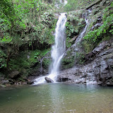
Seeing one waterfall is great. Seeing another one up the stream makes it all the more enjoyable. At the moment, it is not known if the waterfall you see above has an official name. It sits along the same river stream that feeds its baby sister, Fukugawa Taki, roughly separated by a 45 minute hike along the stream. Hence, the momentary name we have given it is Fukugawa II. Your journey starts from the top of Fukugawa I. See article on "Fukugawa Falls" to learn how to get to Fukugawa.  

The journey to Fukugawa II is what makes it exciting. Just like the Taa Falls in Ogimi, you have to trek along the river to see it. However, Fukugawa II is not as easy to get to. You have to negotiate over more rock terrain to get further up stream. Rarely will you see any flat, soft areas to walk on. Because of its difficulty, it is highly recommended that only young adults and above go on this venture. But use your best judgment.

Despite, the laundry list of safety precautions below, you can have a safe and fun time. But you do have to be prepared. Again, approach this with a sense of humility and respect towards mother nature. Below are some tips to keep you safe. 

GUIDELINES (PLEASE READ). 
1. VERY IMPORTANT. Plan on getting wet up to your knees. The reason this is soo important is that it is sometimes safer just to walk in the river, rather than hopping and balancing yourself on the boulders & rocks just to keep dry. If the boulders are wet (& best to assume they will be), they will be slippery. Though this rule may seem trivial, it is the most important thing to remember. The biggest risk trekking along this stream is slipping and falling on the rocks. That is why this is Rule #1.
2. DO NOT WEAR TENNIS SHOES!!! Tennis shoes offer no traction and will slip on these rocks. Wear something that has hard soles and has great traction on these kinds of surfaces. If you do not have hard soles you will 'feel' every step you take. And since you will be getting wet, thick heavy boots will only get heavier when soaked. You should wear something that is lighter, has good traction, but still gives you flexibility of movement. 
3. Never go alone. Have a buddy. For this particular river trek, the 'ideal' number is to have at least three (3) hiking buddies if you can. If one gets hurt, then you have the option of leaving one with the injured while the other go gets some help. Cell phone reception is very difficult, if not non-existent in these areas.
4. Tell someone where you will be river trekking at and leave them the GPS coordinate of the starting point. Not everybody, to include Okinawans, will know of this particular waterfall. GPS to the starting point to both Fukugawa I and II is N26 36.488, E128 3.228.
5. Wear something that is long sleeve and light (depending on the weather) for protection against the elements and bugs. 
6. Wear a hat or beanie to keep warm and to protect yourself against the elements and bugs. You will run into many spider webs along the way (Do a 'spider check' with your buddy every now and then). A beanie does offer some bit of protection as a cushion in the event of a fall.
7. Bring some light hiking gloves for grip and protection. You may be required to grab roots, tree limbs, trees, rocks, dirt, etc. in order to negotiate terrain.
8. Highly recommend not wearing shorts. Find something that you don't mind getting wet in and that offers protection against the elements. There 'will' be a few times you will be on your knees or on your rear end as you negotiate some of the terrain. 
9. Apply the '3-Points of Contact Rule' when going over difficult terrain.
10. Maintain a low center of gravity when going over difficult terrain.
11. If something looks unsafe, then don't do it. Find another way to go around it or SIMPLY, DON'T DO IT. Don't try to be brave. Mother Nature will have the last say. 
12. Give yourself plenty of time AND TAKE YOUR TIME. NO NEED TO RUSH. But remember you have add time to get back (before dark!). Recommend you leave early morning time frame.
13. Bring a light backpack for food, water, toilet paper, flash light, survival kit, first aid kit, light rain coat, warming layers, etc.
14. USE THE BATHROOM BEFORE YOU GO! Making natural deposits of certain kind in the wild may not be fun for some.
15.  You will get dirty. Bring a towel, extra socks, extra pair of shoes, shirt, pants, warming layers (Can leave in the car). 
16. Guide Stick. Having a guide stick may end up being more of a hazard than a safety plus. You need your hands to be free to feel and grab. Just be alert when walking through vegetation and take it slow.
17. Skirting the Terrain Vs Walking in the Water. Skirting the terrain can be more of an impediment and little more dangerous. Again, assume on getting wet in order to negotiate terrain safely. Safety should be the considering factor on whatever you should try to do.
18. Tuck in your shoe laces to prevent tripping.
19. Protect & secure items such as your wallet and cell phone from moisture and from getting soaked. 
20. Don't try to be brave. Respect your limits and respect nature.

Beyond Fukugawa II. When you arrive to Fukugawa II, the question then becomes: is there anything worth seeing on top and beyond? The answer is: not really. Pictures have been provided in the photo album. The view from down below is impressive enough. Getting over Fukugawa II is a little more physical demanding and little more dangerous cause of the steepness. On top, there is a man-made bridge-like structure that holds irrigation pipes that feed out water (possibly out to a farm). For safety, try to avoid these man-made pipe bridges. There are small paths off to the side of these bridges (though narrow) that may offer passage assistance to the top. Use your best judgment. Safety First. Again, the view from down below is impressive enough.

Further down the stream is another man-made structure that appeared be a control valve station at one time. The river flattens out and narrows with several 'Y' forks streams along the way. Our turn-around point was at GPS coordinate N26 38.594 E128 51.834 (an estimated 1.5 kilometer distance from Fukugawa II). By the Google map, our turn-around point was roughly 300meters from the nearest road.

Destination Time. The time between Fukugawa I and II is roughly 45 minutes when going at a reasonable safe pace.

Other Waterfalls of Okinawa (沖 縄 滝). Azaka Falls (Ogimi Village), Fukugawa Falls (Nago City), Hira Falls, Meoto Falls (Higashi Village), Ogimi Waterfall (Ogimi Village), Taa Waterfall (Ogimi Village), Todoroki Waterfall (Nago City), Kijoka Falls, Nameless Waterfall (Kunigami)

Tuesday, February 21, 2012

"The Tsushima Maru Museum"

Inside the Tsushima Maru Museum


View Map It! Okinawa in a larger map
Tsushima Maru Museum

      GPS
     LatitudeLongitude
     N 26 13.206E 127 40.366


The Tsushima Maru Museum - Naha City


On August 22, 1944 at 10:12pm, a tragic incident happen off the coast of Akuseki-jima, Kagoshima. An 'unmarked' passenger-cargo ship named Tsushima Maru carrying 1661 people from Okinawa to Japan was torpedoed by an American submarine USS Bowfin. It wouldn't be twenty years after the war that the crew of the USS Bowfin would learn that of the 1418 who perished on that dreadful night, 767 were children. They didn't know it was a ship of fleeing civilians.

It was around this time that war was rapidly approaching on Okinawa soil and residents were advised to leave Okinawa to escape the inevitable confrontation. On August 21, 1944, students, teachers, and other civilians boarded Tsushima Maru from Naha Port hoping to escape the bloodshed. The Tsushima Maru was among 4 other ships in a convoy, two which were classified as gun ships and the two possibly as cargo ships. Of the 826 children who were on that ship, only 59 had survived. Part of the reason why no one knew it was a civilian passenger ship afterwards, was perhaps that the survivors were warned not to speak of the incident by their officials. But after 60 years later, their stories are now being told.

The Tsushima Maru Museum is not about taking sides. Like all war memorials, whether it be on Pearl Harbor or on Okinawa, they all have messages of promoting peace, and for some, the message is to help find inner peace. Tsushima Maru Museum is to give tribute to the innocent lives and dreams that were lost on that dreadful day. And to remind us that war does not always discriminate against its victims; The good, the bad, and the innocent...all get grouped together. The museum is a monument itself spreading the message of world peace. 

Further information. For more information in English about the Tsushima Maru Incident, you can visit the museum website at http://www.tsushimamaru.or.jp/e_index.html. There, you will find personal interviews translated in English of some of the survivors. You can also visit the USS Bowfin Museum at: http://www.bowfin.org/submarine/36/132-tsushima-maru which has other information of the circumstances surrounding the incident.

English Translation at the Museum. There is no side-by-side English translation next to each station at the museum. However, they do offer a English handout that talks about the background and some of the stations you will see. So please ask for one.

Hours/Entrance Fee. For update information on their Hours and Entrance Fees please go to their website at: http://www.tsushimamaru.or.jp/eng/guide/guide1.html

Handicap Accessibility. The main entrance is on the 2nd floor, however, those who are physically disabled can enter on the first floor exit door.

Parking. There is a pay meter for parking next to the museum.

Phone Number: 098 941 3515
Website: http://www.tsushimamaru.or.jp/

Directions. If you are going into Naha using Highway 58 from the north. You will see signs posted that say 'Tsushimamaru Museum'. However, If you are familiar with Kumoji Crossing in Naha (the center point of the Naha Tug-of-War). I recommend you make the right-turn at the Kumoji Crossing intersection (if you are traveling south on the 58). As soon as you pass the Fukushuen Chinese Garden (on the left) make a left turn at the next traffic light. As soon as you make that left you will make the first right (about 100m). Look for signs that point to the museum. The museum will be on your left and is right next to the Naminoue Shrine. The route is highlight in blue above.

Source of information. The Tsushima Maru Museum Website, The USS Bowfin Museum Website, Museum Handout translated in English. 

Friday, February 17, 2012

"Kumaya Cave - Sunabe"

Kumaya Cave -Through the Gate


View Map It! Okinawa in a larger map
Kumaya Cave - Sunabe

     GPS
     LatitudeLongitude
     N 26 19.919E 127 44.848


Kumaya Cave - Sunabe


In Chatan there is a cave known as Kumaya Gama. It sits next to a vacant plot of land in Sunabe not too far from the beautiful Sunabe Baba Beach. To the locals, it is known as a very spiritual place. According to the Japanese inscription on the stone marker, it was during the war that people sought refuge here. It was reported that all those who took refuge survived. Later, an excavation team sponsored by the Chatan Board of Education and the Government of Japan found bones and other artifacts in this area and was estimated to be between 2500-3000 years old.

The cave is currently fenced off and locked. Pictures were only taken from the outside looking in. The Chatan Town Office does oversee the management of the cave but the actual day-to-day care is conducted by another caretaker. 

Directions. The easiest direct route is highlighted by the blue route. Look for street signs that point to the Kumaya Cave. Along the way, you will see signs to Sunabe Baba Beach, a very popular hang out for families. 

Other Publicly Known Caves. Yabuchi Cave Ruins, Futenma Shrine & Cave, Kin Kannonji Temple, The Gold Hall in Kin Town.

Monday, February 13, 2012

"Meoto Falls (Tachigawa Waterfall)"

Meoto Falls


View Map It! Okinawa in a larger map
Meoto Falls

     GPS
     LatitudeLongitude
     N 26 37.851E 128 12.866


Meoto Falls (Tachigawa Waterfall)


In Higashi Village there is a waterfall that is referred to by the locals as the 'Married Couple's Waterfall'. It is Meoto-Taki (or Tachigawa Falls), which flows from the Tachigawa River. The Japanese word 'meoto' in English gives reference to a 'married couple'. The main highway goes right over it, and you wouldn't know it if you were going on a Sunday drive. The Meoto-Taki is unique in that it has two separate waterfalls in close proximity, each having its own pool of water. And being that there are two, this may be the reason for the metaphorical description.

The Meoto-Taki is unique in another sense, in that part of it (or maybe all of it) sits on private property. At least the main entrance to the waterfall is on private property. There is a cafe and a pension on the same grounds. The gentleman who owns the land welcomes visitors. On his own time he does custom wood work for inquiring customers. He doesn't speak much English, but that shouldn't stop you from meeting a new friend and practicing some Japanese. He understands that people come here to view the waterfall. He is a very friendly gentleman.

Hours. Because the entrance way and part of the waterfall sits on private property, there are set hours where you can visit. Hours are from 11am to 7pm. Closed on Wednesdays. Cafe: 098-043-2186.

How to go about visiting. Because the waterfall entrance does sit on private property, it does provide an odd situation for many, and maybe a little uneasiness about walking directly into someone's yard visiting a waterfall. Just to make you feel at ease, recommend you go ahead and ask one of the staff if it is okay to see the waterfall. They know that people come here to see without asking, but it doesn't hurt to ask and it shows good manners and a sign of respect.

Cafe. The cafe menu is currently in Japanese, but they do have cheese-cake, tea, and coffee. There is a terrace with a nice view of the ocean and a chance where you can relax as you absorb the fresh air. It is not a bad place to enjoy your cup of tea.

Going for a swim. The pools of water are deep enough where you can take a short swim on a hot day. Keep in mind, that other families come here and visit. Though they did say it was okay to swim, I would just ask beforehand as a sign of politeness. Otherwise, it might be equivalent to going into your neighbor's swimming pool without first asking permission.

Directions. Look for a sign with a coffee cup on it along Highway 70. Behind the sign is the parking lot for the cafe. On the opposite side, you will see a two story building and an entrance. This is where you go in. You will see a walkway that takes you down the waterfall. Just remember there are two. To get to the first one, you will see a wooden walk-way that takes you down to the first level. If you skip the wooden walk-way and continue on the pavement, you will go further down to the second waterfall.

Another View Point. If you were to go 100 meters pass the cafe along the main highway you will see a visitor's stopping area. To the right of that is a road that takes you to another viewing area of the ocean. You can walk down to the beach but the steps are very uneven and may have overgrowth along the way. Use caution if you decide to go down. It is a nice view of the ocean down below however. Note: You are not allowed to take anything from the beach or its waters at this location, this includes lobster or clams. You can scuba dive but cannot take anything from the ocean. Spear guns of any kind are not allowed. There will be a fine if caught. Fishing with a fishing pole is okay. 

Other Waterfalls of Okinawa (沖 縄 滝).
Azaka Falls, Fukugawa Falls, Hira Falls, Ogimi Waterfall, Taa Waterfall, Todoroki Waterfall, River Trekking to a Nameless Waterfall (Fukugawa II), Kijoka Falls, Nameless Waterfall (Kunigami).

Other Places of Interest Nearby. The Higashi Museum, The Sakishima Sappanwood Tree, The Azalea Festival (March Only).

Thursday, February 9, 2012

"The Sakishima Sappanwood Tree - Higashi Village"

The Sakishima Sappanwood Tree of Higashi Village


View Map It! Okinawa in a larger map
The Sakishima Sappanwood Tree (Higashi Village)

     GPS
     LatitudeLongitude
     N 26 38.235E 128 09.779


The Sakishima Sappanwood Tree - Higashi Village


Not too far from the Higashi Museum is an intriguing looking tree tucked away in the treeline along the Fukuji River. It is considered to be one of Higashi's natural monuments and is considered to be the largest one of its kind on Okinawa proper. It is the Sakishima Sappanwood Tree of Higashi Village. According to the Higashi Village Office, the tree reaches to about 18 meters in height and about 2.9 meters in circumference at chest-height. Surrounding the tree are its tall, thin wall-like roots grounded in a wavy pattern. It is a fascinating wonder of nature and one of many on Okinawa to see.

Author's Note. The exact scientific classification could not be determined with 100% certainty by the author. Various information has floated around on the internet but nothing from a reputable source. Other Sakishima Sappanwood Trees can be found on Iriomote (maybe the largest within the Ryukyu Archipelago).

Directions. The tree is not far from the Higashi Museum. See map above. Study the landmarks that take you to the Museum. Once you pass the Highway 331 and 70 intersection look for two landmarks along Highway 70 that will take you to the museum (blue route). There are two posted along Highway 70. One is a 'vending area' for tourist and the other is the 'Y-Fork' in the road where you turn into. At the 'Y-Fork' turn-off you will see a radio antennae looking structure to the left. There will also be signs posted on the ground in Japanese. Click here to see what it looks like. Once you are along the 'blue route' at some point you will have to cross to the west side of the Fukuji River. Look for a parking area with a sign for a landmark. The tree is within the treeline of this parking area.

Other places of interest nearby. The Higashi Museum, The Azalea Festival (March Only), Meoto Falls.

Saturday, February 4, 2012

"The Higashi Museum"

Inside the Higashi Museum


View Map It! Okinawa in a larger map
The Higashi Museum

     GPS
     LatitudeLongitude
     N 26 38.469E 128 10.029


The Higashi Museum


Probably one of many least known museums here on Okinawa, the Higashi Museum, for its size, is neatly crafted and well organized. If you are into birding or wildlife here on Okinawa, then it might be worthwhile to see their collection of 'stuffed' birds and other wildlife that are professionally on display. They even have a few live snakes in a glass case on display, to include the notorious and much feared, Habu. Much of the museums covers the agricultural history and the lifestyle of Higashi people of the past. Though nothing is translated in English, you do get a sense how life was like many years ago for the Higashi villagers. If you have a friend that can read Japanese and speak English, then recommend you bring him or her along to help you decipher some of the history surrounding this beautiful part of the Yanbaru Forest. Higashi and many villages further north on the eastern side of Okinawa contain many hidden cultural and natural 'gems' that even many Okinawans may not know about. A large part of it has to do with its location, with the north eastern side of Okinawa being less frequented by transients. The museum sits next to the Fukuji River and next to the museum is a small park and a view of the Higashi Mountains.

Fukuji Dam Back Entrance. If you were to pass the museum and continue on you will run into the back entrance of the Fukuji Dam (Yellow route above). Vehicles are not permitted at a certain point but you can walk inside and see what was once a family gathering area along the river bed. It is a very similar set up to that of the Haneji Dam Family Picnic Area in Nago where kids and parents can splash and have fun in the water. The staff had mention that it is being renovated (road construction) and hopefully some time this year it will accessible for vehicles.

Directions. The turn-off is something you wouldn't expect to lead you to a museum. Study the landmarks carefully. There are two posted. One is a 'vending area' for tourist and the other is the 'Y-Fork' in the road where you turn into. At the 'Y-Fork' turn-off you will see a radio antennae looking structure to the left. There will also be signs posted on the ground in Japanese. Click here to see what it looks like.

Note: They had at one time offered a brochure in English about Higashi and its cultural assets. Lack of English speaking visitors might have contributed to the temporarily halt of this publication. However, with more and more English speaking visitors arriving, it may re-ignite enthusiasm to providing more and more multilingual material for visitors.

Closed: Mondays, If holiday falls on Monday – closed on Tuesday. Closed on national holidays, Okinawa War Memorial Day (June 23rd), December 29-January 3rd.
Hours: 10am-6pm (Last admission 5:30pm)
Fee: Adults/College Students 200 Yen ( 160 Yen/ 15 or more). Elementary to Highschool Students 100 Yen (80 Yen/ 15 or more)
Phone Number: 098-051-2828
Website: http://www4.ocn.ne.jp/~yamamizu/
Taking Pictures: Allowed inside

Other places of interest nearby. The Sakishima Sappanwood Tree, Meoto Falls, The Azalea Festival (March Only).