Search Map It! Okinawa

Sunday, March 25, 2012

"A View and The Shinugu Shrine Ruins"

Zooming in from the Shinugu Shrine Ruins

View Map It! Okinawa in a larger map
A View & the Shinugu Shrine Ruins

     GPS
     LatitudeLongitude
     N 26 22.267E 127 58.863


A View and The Shinugu Shrine Ruins


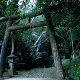
A small plateau lies on top of Miyagi Island and on its eastern edge lies a great viewpoint looking further down the island and parts of Ikei Jima to its north. The zoomed image you see above is of a park down below near the Nagusuku Udun. The viewpoint is collocated on the Shinugu Shrine Ruins. The ruins were first discovered by Shinjun Tawada and was named in 1933, the Shinugu Shrine Shellmound. Today, Mr. Shinjun Tawada is considered to be the father of Okinawan Archeology. Further excavation would lead to discoveries of artifacts “made from clay, stone, shells, and bones”. Also, the excavation would lead to evidence (forty pieces of artifacts) that would seem to indicate that the villagers had “in-ground living quarters”.

There is one point of clarification that needs to be settled. According the translated sign in English, it is said that these “ruins are now known to be the largest village in Okinawa”. Perhaps it is meant that these are the largest ruins of its kind found on Okinawa. The term “village” has various conceptual meanings in terms of size and composition. Today, there is not much to see of these ruins; just a few stone markers placed by the town. It is difficult to get the full scope and size of the area. According to the translation, the ruins were “returned to the earth where they were found for storage purposes”.

The view on top is worth seeing. It gives you an idea of the complex landscape the Okinawans long ago on Miyagi Island had to endure for many years. The location is not far from the Yan Spring down below. It is just a short drive up as you traverse the hillside. To see other scenic views from this area, please click on the photo album above or click here.

Source & Translation. Information provided by the Uruma City Board of Education. 

Other places of interest nearby. The Nagusuku Udun, The Yan Spring

Thursday, March 22, 2012

"The Yan Spring - Miyagi Island"

The Yan Spring (Yanga)


View Map It! Okinawa in a larger map
The Yan Spring

     GPS
     LatitudeLongitude
     N 26 22.254E 127 58.937


The Yan Spring - Miyagi Island


Okinawa is full of natural springs. This one found on Miyagi Island is the Yan Spring (Yanga) and is considered one of Uruma City's cultural assets. It is not too far away from the Nagusuku Udun roughly 400 meters away. Next to the spring is an explanation sign translated in English provided by the Uruma City Board of Education. It reads:
"Comprised of Ryukyu limestone and Tertiary Strata marlstone (also known as kucha in Okinawan), the soil of Miyagi Island is ideal for trapping rainwater, and thus the island has abundant spring water. The yanga has the highest output of water among all springs on the island;

It is recorded in the Kyuyou(*1) that the village heads of Yonagusuku Magiri(*2), Penchin(*3) Nakamura and Pechin Ikemi, had restored the yanga with the help of 19 villagers in 1849. The stone structure that they reconstructed leaves evidence of construction techniques of the time. The then-villages of Uehara and Miyagi did not use the water only for daily needs; the spring is considered historically significant, for its water was used for wakamizu(*4) and also for ubumizu(*5)"

Notes:
1. Kyuyou: a book that records the history of Okinawa
2. Magiri: a modern-day equivalent of village, towns, and cities during the Ryukyu Kingdom Era
3. Pechin: a rank in the old Ryukyu Kingdom Era
4. Wakamizu: water used in the New Year
5. Ubumizu: water used for celebrating birth

Using spring water for 'wakamizu' and 'ubumizu' is common throughout Okinawa for those who still practice traditional customs. It is also not uncommon to find symbols of worship like utaki's next to springs. Long ago, water was treasured as the life blood for communities, and places of worship were erected to give thanks for such sources of water.

Author's note. The translation states the Yan spring “has the highest output of water among all springs on the island”. This more than likely refers to Miyagi Island and not Okinawa proper. There are other springs throughout Okinawa that also have high outputs of water as well.

The Other Natural Spring. There is another natural spring to the south of the Yan Spring. There is no official title to it and we simply refer to as the 'Miyagi Garden Spring'. See map above. It is highly recommended you navigate on foot to this location. If you walk just further to the south of the 'Miyagi Garden Spring' you will also see some interesting terrain.

Other Natural Springs on Okinawa Prefecture.
Kanumou Well in Awase (Okinawa City)Okawa, The Natural Spring (Kin Town)Nakandakari Hijya, Natural Spring (Nanjo City)Noroga and Remnants of an Old Sugar Factory (Uruma City)Small Kunigami Cave Spring (Kunigami Village), Tabagaa Water Spring (Uruma City), The Dragon Tree (Naha City), Ubugaa (Okinawa City), Water From Hands (Nago City).

Sunday, March 18, 2012

"Nagusuku Udun - Miyagi Island"

Nagusuku Udun


View Map It! Okinawa in a larger map
Nagusuku Udun

     GPS
     LatitudeLongitude
     N 26 22.243E 127 59.118


Nagusuku Udun - Miyagi Island


This is the Nagusuku Udun of Miyagi Island. The term 'Udun' gives reference to a burial tomb of someone of high status such as king or lord. Like most Okinawa legends, the story of Nagusuku (or Naagusuku) Udun is shrouded in mystery. The explanation sign written in Japanese tells of a Kyanbaru goddess that was given a spiritual message about a large drift wood that was beached in a place called 'Dumaibama'. The villagers had heard about this message and went to go see it for themselves. The villagers had tried to pull it out....but couldn't. The Kyanbaru goddess said the log won't move unless a noro from Nakadomari takes lead in moving it. When this happened, the villagers then were able to move it and they used it to build the original Udun. Today, the Nagusuku Udun is considered a sacred place and guardian for the people of Miyagi Island. It is also believed that an 'Aji' from the Hokuzan region is buried here. The term 'Aji' is used to describe a local lord and 'Hokuzan' was the old term to describe the northern region of Okinawa. The term now used is Hokubu. In 1962 the Nagusku Udun was rebuilt with concrete.

More for the O-Files. The explanation leaves you with more questions than answers, such as the whereabouts of 'Dumaibama'. And does Kyanbaru have a connection with today's Kyan district of Itoman. If the area referred to as Nakadomari is the same area in Onna Village, then it shows how expansive the communication network reached to some of the remote areas of old Okinawa. One has to remember, there was no bridge that connected to the outer islands off the Katsuren Peninsula long ago.

The story also raises questions about the importance of the drift wood. Today, we wouldn't consider a washed up log as anything important. However, the story does shed light on how much power certain people had back in the old Ryukyu Kingdom. A Noro's spoken words were seen as if it came from the gods themselves. One did not question Noros back in those days.

Directions. The Nagusuku Udun is tucked away in a small town of Yonashiromiyagi on Miyagi Island. See the map and study the designated land mark. Near the Green Thumbtack you will also see an official Uruma City marker pointing to the Udun. However, do not follow this sign with your car. Read parking instructions below.

Parking. It is highly recommended that you park in the vicinity of the Green Thumbtack (see map above) and the navigate on foot to the burial tomb. It is not a far distance to the tomb from this location. It is also the widest area you can park your car without disrupting the flow of traffic. If you are new to this area and you try to navigate by car to the tomb you will find yourself in some very tight roads and corners.

Viewing Area. Near the tomb is another park to its north. There you will see a viewing tower where you can get a good view of the Miyagi greenery and outlying towns.

Sunday, March 11, 2012

"Kijoka Falls – Ogimi Village"

Kijoka Falls (Nana-taki - foreground)


View Map It! Okinawa in a larger map
Kijoka and Nana Taki

     GPS
     LatitudeLongitude
     N 26 42.125E 128 08.937


Kijoka Falls – Ogimi Village


Often referred to as just Kijoka-taki, this waterfall in the Kijoka district of Ogimi Village is broken up into two parts. The Kijoka residents call the smaller of the two waterfalls, Nana-Taki (foreground waterfall), and the much bigger of the two, Kijoka (background waterfall). Together, they make one beautiful couple and a wonderful scene. The location of Kijoka mimics that of its sister waterfall to the south, Todoroki of Nago City. Both are tucked away nice and neatly at the corner's edge of their respective towns, and both are relatively a short walking distance from the parking area.

Kijoka's beauty also rivals that of its sister, Fukugawa, also in Nago City. But Kijoka is unique in one respect. There is a Torii Gate at the entrance about 50 meters to its front, and to the right is an utaki (place of worship) for the local residents. The Kijoka Falls is a very peaceful place, and one of many waterfalls you should see during your stay here on Okinawa.

Author's note. Because Kijoka (and Nana) reside very close to a sacred area, one must conduct him or herself accordingly. Loud noise and 'energetic' behavior i.e. swimming, climbing around, shouting etc., that you could normally do at other waterfalls is probably not a great idea here. Initially, it is best to have the same mindset as if you were going into a temple, but one has to gauge the atmosphere to get a feel what is acceptable or not. As the saying goes, “When in Rome, do as the Romans do”.

Ceremonies. It is understood by the local community that visitors come here to see the Kijoka Falls, but if in the event there is some kind of worship or prayer ceremony in progress, you may want to consider coming back at another time — unless the local residents say it is okay to stay. Taking photos of any kind during prayer ceremonies is highly advised against unless given 'expressed' permission by the people involved. It perhaps... is best not even to ask, just better to come back at another time. This kind of visible restraint sometimes goes a long way in showing and winning respect.

Directions. Kijoka Falls is approximately 4km to the south of the Okuma Recreational Facility and near Highway 58. If driving north, you will notice a 'Y' fork off the 58. This is where your route starts. See blue route above. As soon as you turn right at the 'Y' fork, turn on the first right. If you go pass the 3-Story building with a large 'Family Mart' billboard on top (picture of this landmark is not available at the moment), then you have gone too far. After the right turn continue straight. The road will be tight. Look for a greyish building as a cue for the next turn-off. At this landmark, you will make a right. The road will narrow and you will see a small parking area to the right. If you go any further you will see the Torii Gate. Do not park in this area. It is too narrow.

Other waterfalls of Okinawa (沖 縄 滝)
Azaka Falls (Ogimi Village), Fukugawa Falls (Nago City), Meoto Falls (Higashi Village), Ogimi Waterfall (Ogimi Village), Taa Waterfall (Ogimi Village), Todoroki Waterfall (Nago City), River Trekking to a Nameless Waterfall (Nago City). (Aha and Hiji Falls not listed at the moment).

Saturday, March 3, 2012

"R/C Paradise - (Now Kitanakagusuku)"

R/C Paradise in Kadena

RC Paradise

     GPS
     LatitudeLongitude
     N 26 21.160E 127 44.639


R/C Paradise (Now Called R330)


NOTICE!!! SOURCES HAVE INFORMED US THAT R330 IS NOW CLOSED FOR BUSINESS AS OF EARLY FEBRUARY 2013. THIS POST WILL REMAIN OPEN TO INFORM THE AUDIENCE MEMBERS OF THE SITUATION. UPDATES OR CHANGES WILL BE AMENDED UPON NEW FINDINGS.

UPDATE!!!: September 18, 2012. R/C Paradise has officially re-opened in Kitanakagusuku and is now called R330. It is still undergoing internal remodeling. It's current hours are now noon to 5pm due to electrical rewiring. Click on this link for Map Location It is off Highway 330 just north of the Plaza Shopping Center. You can only access the store on the southbound lane. This post will be redone once their shop has been completely remodeled. For current information please visit there website http://rajiten.ti-da.net/.


DIRECTIONS. The store is on Highway 330 just north of the Highway 85 and Highway 330 Intersection on the east side of Highway 330 (right if traveling north). You cannot access it on the northbound lane you have to be in the south bound lane. It is two buildings just north of the Plaza Shopping Center Parking lot. The location will be revisited shortly to see what upgrades have been in place. 

UPDATE!!!: July 22, 2012 - As of July 16, R/C Paradise at the Navel Kadena is CLOSED and pending relocation. The store's new location has not been officially announced. This post will be updated once official information has been announced.

For all you remote control car enthusiasts, R/C Paradise is indeed a 'paradise' come true. It is located on the 3rd Floor of the Navel Kadena building/shopping center in Kadena. They have a myriad of remote control cars, R/C parts, and gadgets to ramp up your R/C hobby delight. In the front and in the back are miniature race tracks to give your remote control car a spin (membership required). Each track is suited for a particular kind of R/C vehicle i.e. drifting vehicles, off-road types, etc. If you are really into remote/radio control vehicles then this is the place to check out.

Track usage. Membership is required to use the race tracks. It is fairly inexpensive. 500 Yen for five hours. 1000 Yen for all day. Membership is not required if you just want to sit and watch.

English. The staff may or may not speak English. However, you are more than likely to find other English speaking customers utilizing the race tracks if you need help or assistance. They are accustom to having many foreigners at their store.

Hours: Open Daily 12pm-11pm (Saturday 11am-11pm)
Phone Number: unavailable
Website/Blog:http://rajiten.ti-da.net/ (Japanese Only)

Directions. R/C Paradise is located on the 3rd Floor of the Navel Kadena Building/Shopping Center (photo of building not available at the moment). Navel Kadena will be spelled out in large letters on their tallest building. The shopping center is on the west side of Highway 58 just north of the Kadena Marina. See Map above.

Other hobby stores in Okinawa. Modelers Core (Okinawa City), Yonkudou (Okinawa City).