|
| The Yan Spring (Yanga) |
View Map It! Okinawa in a larger map
 |
| The Yan Spring |
GPS
| Latitude | Longitude |
| N 26 22.254 | E 127 58.937 |
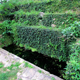
The Yan Spring - Miyagi Island
Okinawa is full of natural springs. This one found on Miyagi Island is the Yan Spring (Yanga) and is considered one of Uruma City's cultural assets. It is not too far away from the Nagusuku Udun roughly 400 meters away. Next to the spring is an explanation sign translated in English provided by the Uruma City Board of Education. It reads:
"Comprised of Ryukyu limestone and Tertiary Strata marlstone (also known as kucha in Okinawan), the soil of Miyagi Island is ideal for trapping rainwater, and thus the island has abundant spring water. The yanga has the highest output of water among all springs on the island;
It is recorded in the Kyuyou(*1) that the village heads of Yonagusuku Magiri(*2), Penchin(*3) Nakamura and Pechin Ikemi, had restored the yanga with the help of 19 villagers in 1849. The stone structure that they reconstructed leaves evidence of construction techniques of the time. The then-villages of Uehara and Miyagi did not use the water only for daily needs; the spring is considered historically significant, for its water was used for wakamizu(*4) and also for ubumizu(*5)"
Notes:
1. Kyuyou: a book that records the history of Okinawa
2. Magiri: a modern-day equivalent of village, towns, and cities during the Ryukyu Kingdom Era
3. Pechin: a rank in the old Ryukyu Kingdom Era
4. Wakamizu: water used in the New Year
5. Ubumizu: water used for celebrating birth
Using spring water for 'wakamizu' and 'ubumizu' is common throughout Okinawa for those who still practice traditional customs. It is also not uncommon to find symbols of worship like utaki's next to springs. Long ago, water was treasured as the life blood for communities, and places of worship were erected to give thanks for such sources of water.
Author's note. The translation states the Yan spring “has the highest output of water among all springs on the island”. This more than likely refers to Miyagi Island and not Okinawa proper. There are other springs throughout Okinawa that also have high outputs of water as well.
The Other Natural Spring. There is another natural spring to the south of the Yan Spring. There is no official title to it and we simply refer to as the 'Miyagi Garden Spring'. See map above. It is highly recommended you navigate on foot to this location. If you walk just further to the south of the 'Miyagi Garden Spring' you will also see some interesting terrain.
Other Natural Springs on Okinawa Prefecture.
Kanumou Well in Awase (Okinawa City), Okawa, The Natural Spring (Kin Town), Nakandakari Hijya, Natural Spring (Nanjo City), Noroga and Remnants of an Old Sugar Factory (Uruma City), Small Kunigami Cave Spring (Kunigami Village), Tabagaa Water Spring (Uruma City), The Dragon Tree (Naha City), Ubugaa (Okinawa City), Water From Hands (Nago City).