Search Map It! Okinawa

Monday, August 25, 2014

Sukumichi Road and the Old Okukubi Bridge

Ruins of the Old Okukubi Bridge


View Map It! Okinawa in a larger map
The Old Okukubi Bridge

     GPS
     LatitudeLongitude
     N 26 27.877E 127 55.977


The Sukumichi Road and the Old Okukubi Bridge

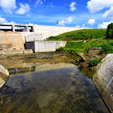
In the days of the Old Ryukyu Kingdom, Okinawans developed an early road system to help them travel from one end of the island to the other. One major road was called Sukumichi which had passed through the village of Kin (present-day Kin Town). The route closed in at a very narrow portion of a major river within the village. This location was called ukukubi, an Okinawan word meaning 'the neck towards the back'. In this case, it is referring to the river's neck up the stream (the narrowest part of the river). The present term for ukukubi is okukubi (奥首), which is the Japanese pronunciation. It was in 1931 at this narrow channel that an arch-shaped bridge constructed of concrete was erected to aid travelers crossing the river. However, the bridge was later demolished by a Japanese garrison before the US invasion took place during the battle of Okinawa.

The bridge became known as the Okukubi-bashi, (bashi - a term meaning bridge). An image of the bridge intact can be seen on location on a historical sign (see image here). Intriguingly, the major river that flowed underneath this bridge became known as the Okukubi River, however the current kanji representation for the river's name (億首川) leads to a different story of how the river's name came to life. See the Legend of the Okukubi River.

Directions/Parking/Amenities. Take Highway 329 till you reach the south end of the Kin Bridge (see Blue Route on map). Turn towards the direction of the dam. You will travel down a hill and see the Kin Dam shortly after (it will be on your left). Near the bottom of the hill you will see small parking area with a toilet facility. The Okukubi Bridge ruin is about a 75 meters in front of the dam spillway.

Author's Notes
1. It is not certain by the author where exactly Sukumichi begins and ends

Reference.
1. Historical Sign on location, Kin Town Board of Education

Friday, August 15, 2014

The Iha Nuru Tomb

The Iha Nuru Tomb


View Map It! Okinawa in a larger map
The Iha Nuru Tomb

     GPS*
     LatitudeLongitude
     N 26 25.376E 127 48.924

     *GPS is to the LandMark


The Iha Nuru Tomb, Uruma City

Directly above the Ishikawa Tunnel is an Ohaka (grave) that scholars believe house the remains of a Noro, a female priestess assigned by the royal government during the Old Ryukyu Kingdom. It is believed that this particular Noro was responsible for the areas belonging to Iha, Yamashiro, Kadekaru, and Ishikawa. (1)

Contents. Inside the grave are said to be 15 urns with each urn containing the remains of 2 individuals (a total of 30 people). However, none of the urns had names inscribed on it. It is not certain how the then-Ishikawa City Board of Education (Now Uruma City) made the conclusion that the remains belonged to the Noro of that region. Other source documents (chronological records, etc.) are being pursued that may unravel the history behind the tomb's contents. The grave sits in the Iha District of Uruma City.(1)

Author's Speculation (Conjecture). The style of the urns may be indicative of the status of each individual. It cannot be assumed that every Okinawan was buried with the same honors or care during that time frame. It would seem to make sense that significant individuals (lords, priestess etc.) received extra care and attention during their burial. The sign on location posted by the Uruma City Board of Education does show an image of the somewhat decorative urns found inside. Additionally, it is quite possible that the tomb houses remains of more than one Noro.

Notes.
i. The Uruma City historical sign uses the word Nuru. Nuru is the old Okinawan pronunciation for Noro.(1)

Reference.
1. Sign, on location, Uruma City Board of Education.

What to Bring. Be prepared for mosquitoes during all times of the year. Vegetation may be little high in some areas. Recommend a guide stick to move through the vegetation as well as good shoes. Be on the lookout for snakes.

Other Places to Visit Nearby. Iha Castle Ruins.

Other Noro Tombs. The Kanna Noro Tomb.

Directions. Take Highway 329 into Uruma City till you run into the Highway 6/Highway 329 Intersection (South of the Ishikawa Tunnel). Continue east on Highway 6 for a few hundred meters. You will see brown historical markers on your left (signs for both the Iha Castle and Nuru Tomb). When you get to the Iha Nuru Tomb Historical sign, you will see a dirt trail going north. Walk about 100 meters. To the right you will see an opening. Vegetation may be a little high. Continue through this opening to you see a set of steps leading you to the tomb.