Search Map It! Okinawa

Thursday, December 27, 2012

"Awa-dake"

On the far left is Awa's 1st peak and near left of middle is Awa's summit. Yae is in the middle, with Katsuu and Furushi to the right.


View Map It! Okinawa in a larger map
Awa-dake
     GPS
     LatitudeLongitude
     N 26 37.247E 127 56.184

        *GPS to Parking Area


Awa-dake

Across from Yae and Katsuu sits their smaller sister Awa, which is only about 20 meters shy of both her siblings – Yae-dake being the tallest at 454 meters and Katsuu at 452 meters. But the climb to the top of Awa is what sets her apart from her sisters. It takes about 5-6 hours to complete the entire Awa loop which is composed of two prominent peaks that define the Awa-dake mountain range. This time window includes a little exploring that you will be doing mid-way as you search out some of the caves along the way. Because the length of time it takes to complete the Awa trail please read the entire post. There are some safety considerations that must be taken into account.

Summary Information.
Name: Awa-dake
Elevation of the Highest Point. 432 meters (1417 feet)(1)
First Peak Coordinate: GPS N26 37.507 E127 55.798
Second Peak (Highest) Coordinate: GPS N26 37.768 E127 55.719
Starting Point Coordinate: GPS N 26 37.248 E 127 56.195 (Katsuyama Community Center)
Estimated Time for Completion: 5– 6 hours (to complete the entire trail loop, this includes exploring midway).
Parking Area Area: Same as starting point
Recommended Emergency Rendezvous Point: Same as starting point
Trail. Trail is marked off by colored tape.
Trail Map: 8.5 x 11 inch PDF (Full ColorReduced Color), JPG (Full ColorReduced Color).

Safety and Planning Considerations (Must Read!!!).
Time of year. Hiking any hilltop or mountain range in Okinawa will be challenging during the summer season. The most enjoyable time is during the colder months. If you do climb Awa during the warm/hot season it is guaranteed that your body will lose tremendous amounts of water....guaranteed. This is especially true during the first hour of the hike as you will trapped along with the heat contained by the forest jungle partway. Recommend you hydrate the day before and bring at least 4 liters of water with you, along with some nourishments to replenish the electrolytes in your body. Though Awa is nothing like climbing Mount Fuji in Japan, the heat will rip you apart. And because you have to bring large amounts of water and nourishments, this will add to the weight of your pack further wearing you down. You will probably know within the first hour of the hike if you think you can finish the entire loop. If at anytime you feel like that you cannot complete the entire loop, then turn back and try again at another time. Do not take this hike lightly.
Hours in the day. Because this entire loop takes about 5-6 hours, you have to make sure you leave yourself enough time to come back before dark. Departing in the morning is the best time.

Awa-dake Hiking Sequence. Please read the following hiking sequence. Part of this trail is shared by the trail that takes you to Furushi-dake. You can also print an 8.5 x 11 inch PDF/JPG trail map above to get an idea of the trail layout as you review the hiking sequence.

1. Parking. Park your car at the Katsuyama Community Center (Green Thumbtack above). This is important. Do not park near the trail's main entrance. This will make it difficult for farmers to bring in their equipment to attend their crops.
2. From the community center, you have to walk towards the main trail entrance that is designated  by this sign (see also trail map and the map above).
3. From the main entrance, you will be walking almost due north about 500 meters till you reach a juncture in the trail. Along this stretch, you will pass through orchards on both sides and then the trail slowly creeps into the jungle forest.
4. The trail juncture. Towards the end of the 500 meter stretch, you will be inside the forest jungle. You have to keep your eyes open for color tape tied around tree branches on both sides of the trail. There may be small wood signs directing you the way, but this may not always be the case. The trail juncture splits into three separate trails. The trail to the left takes you clockwise to Awa-dake, the trail in the middle takes you counter-clockwise to Awa-dake, and the trail to the right takes you to Furushi-dake.  As a personal recommendation, taking the Awa-trail clockwise will be more enjoyable.
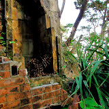
5. The First Cave. You will run into the first cave within the hour if you take the trail clockwise. There is a wood sign next to it and says that it was used by the Japanese soldiers during World War II. The cave is actually a three level cave. You have to be very careful inside since the outer walls are very loose, and with all the ruble, there is potential of tripping and falling.
6. The Second Cave. Before you reach the first peak you may see a small wooden sign that points you to the second cave. This sign is small. Keep your eyes open for colored tape along the trail that deviates from the main trail. According to the Katsuyama district guide pamphlet this is the story behind the second cave:
Long ago, men who had once worked for the Shuri King came to live in the Katsuyama area. At first, the village people had welcomed them. Initially, the men from Shuri worked with the villagers, but later they became distraught and lazy. They had lost all motivation with their new life, and so they started pillaging from the people and even kidnapped some of the village women. They would hide up in this cave on the Awa mountain side and use it as a base to conduct their sinister activities. As a result, the villagers then concocted a plan that would scare off the bandits forever. In the dark of night, a great number of villagers had set flags on fire mimicking soldiers coming from the south. Out of fear, the bandits fled never to return. These bandits where known as the Sanzoku bandits and their leader was a man that went by the name Kochi Satonoshi (2).
7. The First Peak. The first peak takes about an hour and half to get to. This includes water and rest breaks along the way and the time you will spend exploring the caves.
8. The Second Peak. This is Awa-dake's summit. It is about another hour from the first peak.
9. The Return Trail. The trail continues past the second peak. The trail is not as distinct on this end, and you must keep your eyes open for color tape that marks the path back. It takes about another 1 and half hour to return to the starting point.

Recommended Guidelines (PLEASE READ!!!).
1. Age. Climbing is suitable for young adults who have good agility, mental awareness, and are physically fit. Parents must use their discretion on the ability of their children.
2. Wear shoes or boots that have good traction. Tennis shoes highly not recommended. 3. Snakes. Snakes, including habus, have been seen in this area. Be vigilant.
3. IMPORTANT!!! Bring plenty of water that will help you complete the 5-6 hour excursion. Recommend at least 4 liters of water and nourishments to replenish your electrolytes.
4. Tuck in all loose straps to include shoe laces to prevent getting snagged and tripping.
5. Highly recommend hiking gloves of some kind. You may be required to climb using your hands in some areas.
6. Base your clothing on the time of year and comfort level. It will get windy and cold on the top of the mountain during the colder months. Consider bring a light jacket.
7. Recommend a good hat for shade or cover up with a moist towel.
8. Bug repellent. Bring per your discretion.
9. Let someone know where you are going, and recommend a climbing buddy.

Notes/Source of Information.
1. Elevation was obtained from a Nago City sign board.
2. It is not sure what date this incident with the bandits had taken place, or why they had left Shuri Castle to begin with. Dates and reasons where not given. The name Kochi Satonishi may be incorrect due the translation and variation of the Kanji.

Directions/Parking. Take Highway 58 North and turn on to Highway 449 goings towards Motobu Town. About another 10 minutes later look for large street signs in English directing you to Mt. Katsuu (the Katsuyama Community Center is along this route). Look for the Katsuyama Community Center on the left. This is where you want to park. It will be across a white sign directing you to Mt. Katsuu. See map above for landmarks. Parking location is at GPS N 37.247 E 127 56.184.

Other Hiking Trails on OkinawaKatsuu-dakeFurushi-dake, Motobu Fuji, Yonaha-dake.

Thursday, December 20, 2012

"Furushi-dake"

The Rock Face at Furushi-dake


View Map It! Okinawa in a larger map
Furushi-dake

     GPS
     LatitudeLongitude
     N 26 37.247E 127 56.184

        *GPS to Parking Area


Furushi-dake


Just below Katsuu-dake (Mt. Katsuu) is its smaller sister, Furushi, whose summit blends in among the Katsuu landscape when viewed from a distance. The summit of Furushi-dake is more of a rounded hilltop than a pointy peak, and it's not her best feature — it's her rock face. This is what separates Furushi among her sister mountains in Okinawa. You will be on its edge..literally. The picture you see above (courtesy of Mikesryukyugallery.com) is of Mr. Map It! himself taking a little break near the rock's edge. If you love exploring and hiking, this area in Nago City is a great place for it. Part of the trail to Furushi is also shared by the trail that takes you up to Awa-dake, which sits across Furushi. Awa is an impressive mountain as well, taking about 5 hours to complete the entire Awa loop (next week's post will be on Awa-dake). See below for hiking instructions for Furushi-dake.

Summary Information.
Name: Furushi-dake
Elevation. 375 meters (1233 feet)(1)
Peak GPS Coordinate: GPS N26 37.711 E127 56.121
Rock Face GPS Coordinate: GPS N26 37.668 E127 56.070
Starting Point GPS Coordinate: GPS N 26 37.248 E 127 56.195 (Katsuyama Community Center)
Estimated Time to Peak: 1 – 2 hours (one way, includes visiting the Rock Face).
Parking Area Area: Same as starting point.
Recommended Emergency Rendezvous Point: Same as starting point.
Trail. Trail is marked off by colored tape.
Trail Map: 8.5 x 11 inch PDF (Full Color, Reduced Color), JPG (Full Color, Reduced Color).

Furushi-dake Hiking Sequence. Because the trail is not as straight forward like that of the trail going to Mt. Katsuu please read the following hiking sequence. You can also print an 8.5 x 11 inch PDF/JPG trail map above to get an idea of the trail layout as you review the hiking sequence.

1. Parking. Park your car at the Katsuyama Community Center (Green Thumbtack above). This is important. Do not park near the trail's main entrance. This will make it difficult for farmers to bring in their equipment to attend their crops.
2. From the community center, you have to walk towards the main trail entrance that is designated  by this sign (see also trail map and the map above).
3. From the main entrance, you will be walking almost due north about 500 meters till you reach a juncture in the trail. Along this stretch, you will pass through orchards on both sides and then the trail slowly creeps into the jungle forest.
4. The trail juncture. Towards the end of the 500 meter stretch, you will be inside the forest jungle. You have to keep your eyes open for color tape tied around tree branches on both sides of the trail. There may be small wood signs directing you the way, but this may not always be the case. The trail juncture splits into three separate trails. The trail to the left takes you clockwise to Awa-dake, the trail in the middle takes you counter-clockwise to Awa-dake, and the trail to the right takes you to Furushi-dake. (Note. If you wish to climb Awa-dake, it takes about 5-6 hours to hike the entire loop. You need to bring plenty of water and nourishments, especially during the warmer months of the year. See post on Awa-dake).
5. The Furushi-dake Rock Face. As you are hiking towards the Furushi summit, you will run into a T-intersection juncture. See photo here. Going right takes you to the Rock Face. Going left takes you to the summit.
6. Warning. The Rock Face is an impressive place to see but it does get really narrow and a little dangerous. You will see a wood sign that says “きけん” It just mean 'danger', and be on guard. From here you will be skirting a narrow trail along the edge of the rock face. You will have to hunch over many places along this part. Watch out for your head.
7. Warning. The narrow ledge. There is a part along the rock face that you have to climb a little to continue further. The trail ends about 40 meters later so it is not necessary to proceed ahead. It can be little nerve-racking at this point. The view is already impressive enough before this point. It is recommended that only a few people at a time proceed ahead as the entire ledge is narrow. Please see this YouTube Video to get a preview of what to expect at this juncture. For your comfort level, you may want to bring a carabiner and a safety harness. It is also recommended that you climb on and down from the ledge on your stomach. This will keep your center of gravity low and you will have more stability on the surface.

Recommended Guidelines (PLEASE READ!!!).
1. Age. Climbing is suitable for young adults who have good agility, mental awareness, and are physically fit. Parents must use their discretion on the ability of their children. Do not recommend bringing children to the Rock Face, but that is the parent's discretion.
2. Greatest dangers are tripping and falling. Wear shoes or boots that have good traction. Tennis shoes may be too slippery on some rock surfaces.
3. Snakes. Snakes, including habus, have been seen in this area. Be vigilant.
4. For your comfort level, you may want to bring a carabiner and a safety harness (Rock Face only).
5. Tuck in all loose straps to include shoe laces to prevent getting snagged and tripping.
6. Highly recommend hiking gloves of some kind. You may be required to climb using your hands in some areas.
7. Base your clothing on the time of year and comfort level. For this particular trail there are no specifics for attire.
8. Bring plenty of water and nourishments.
9. Recommend a good hat for shade or cover up with a moist towel.
10. Bug repellent. Bring per your discretion.
11. Let someone know where you are going, and recommend a climbing buddy.

Notes/Source of Information.
1. Elevation calculated at http://www.daftlogic.com/sandbox-google-maps-find-altitude.htm. This is not an official Nago City measurement. Official measurement can not be acquired at this time.

Directions/Parking. Take Highway 58 North and turn on to Highway 449 goings towards Motobu Town. About another 10 minutes later look for large street signs in English directing you to Mt. Katsuu (the Katsuyama Community Center is along this route). Look for the Katsuyama Community Center on the left. This is where you want to park. It will be across a white sign directing you to Mt. Katsuu. See map above for landmarks. Parking location is at GPS N 37.247 E 127 56.184.

Other Hiking Trails on Okinawa. Awa-dakeKatsuu-dake, Motobu Fuji, Yonaha-dake.

Tuesday, November 20, 2012

"The Weenuatai Ohaka - Kanna, Ginoza Village"

The Weenuatai grave sits inside a small cavity


View Map It! Okinawa in a larger map
The Weenuatai Ohaka, Kanna Ginoza Village

     GPS
     LatitudeLongitude
     N 26 28.594E 127 57.706


The Weenuatai Ohaka - Kanna, Ginoza Village


At the Yoriage Forest in Kanna, Ginoza Village, sits a historical tomb called the Weenuatai Ohaka (ウェエヌアタイのお墓). Ohaka is a Japanese term for tomb or grave. What is special about this grave is that it predates the very familiar turtle-back tombs that are often seen throughout Okinawa's landscape. It is composed of wood dating back around 1350 AD. The turtle-back tombs on Okinawa are believed to be first used around the 18th Century. Below is a summary of what researchers found inside the original grave:
130 bodies which included 58 male remains, 47 female remains, and 25 remains of gender unknown. Of that mixture, 40 were considered to be young adults, 6 young children, 17 toddlers, 11 infants, and 6 newborns.(1)
Additionally, 364 items were found...
288 man-made items and 76 natural items; Man-made items included hair pins, combs, rings, products made of shells, old money, a glass ball, tea cup, sake cup, and nails. Natural items included: two pieces of seashells and remains of a crab, dugong, dog, and a rat.(2)
The Weenuatai Ohaka has since been rebuilt with new and original pieces of wood. The tree in which the wood came from was said to be over 600 years old. Information provided by the Ginoza Museum mentions it was found in the 'Dakiyama Forest', but it wasn't exactly clear if the tree or the grave was found at this forest. Where exactly is the 'Dakiyama Forest' is not exactly certain at this time.(3)

Such wooden graves were said be the forerunner of the stone graves that are more familiar today, but exactly what part of Okinawa they were used is not quite clear. Many were hardly left due to the war and some where found in caves. Nails where not used to hold them together. 1912 was said to be the last time remains were put in the Weenuatai Ohaka. The refurbished grave is now made of 34 pieces of wood; of the 34, 17 are new pieces and 17 are from the original grave. A display replica of the Weenuatai Ohaka can be seen at the Ginoza Museum. See article on the Ginoza Museum.

Advisement. The Weenutai Ohaka is a grave. Please be respectful in mannerism. It rest highly visible off the main trail and sits in a small cave-like cavity. Villagers still come here to pay respects to their earlier ancestors. It is a place of meditation and reflection.

What to bring. To protect yourself from critters, it is highly recommended you wear long sleeves top and bottom, bring a pair of hiking gloves, a neck towel, and a hat. There is a lot of moisture in the area and it will attract a good amount of insects. Consider bringing bug repellent. Though the Weenuatai Ohaka sits off a well beaten path, it is recommended that you bring a guide stick to probe areas for snakes and to knock down spider webs should you decide to venture elsewhere.

Author's Notes.
1. It is believed that the rest of the remains belonged to older adults (speculation). Verification is required.
2. Interesting to note that dugong remains were found and makes one wonder to what extent and what role the mammals played in early Okinawa culture.
3. If the suffix 'yama' is the same 'yama' used to describe a mountain, then it is possible that the Dakiyama Forest belongs to a mountain range in the nearby area.
4. It is not clear what the meaning of the word 'Weenuatai' means.

Source of information. Leaflets provided by the Ginoza Village Museum (Japanese). Visions of Ryukyu: Identity and Ideology in Early-Modern Thoughts and Politics, Gregory Smits, 1999, Pg 83 (Turtle-back Tombs).

Related Articles. The Katana and the Ginoza Museum, Kanna's Mysterious Yoriage Forest.

Directions. The Weenuatai Ohaka is located at the Yoriage Forest which is part of the Kanna Village Park and is on the opposite side of Highway 329 from the Kanna Thalasso Resort. See the map for LandMarks.

Wednesday, November 14, 2012

Kanna's Mysterious Yoriage Forest

Fresh water at the Yoriage Forest


View Map It! Okinawa in a larger map
Kanna's Yoriage Forest

     GPS
     LatitudeLongitude
     N 26 28.672E 127 57.643


Kanna's Mysterious Yoriage Forest


In a small section of land off Highway 329 is a tiny forest park in Kanna of Ginoza Village. In no way does it match the enormous size of the Sueyoshi Forest Park of Naha City, but it does have a handful of natural wonders and mysteries to see. You might call this the 'Fangorn Forest' of Okinawa. It is one of the most eeriest and mysterious places on the island. You are about to enter — Kanna's Yoriage Forest (漢那 の ヨリアゲ 森).

As you arrive at the entrance, you will notice a very large Gajimaru Tree upheld by a man-made pillar. It is a very impressive example of man working with nature to promote prosperity and longevity. And not far from the tree is a fountain of fresh pouring water. Symbolically, this is very important. It is because on these same grounds that the 'Water Kami-sama' (Water god), named Kawazukasan Ouibe (カワズかサノオウイベ), is revered and worshiped(1). This same god was also mentioned in 1713 in a historical document referred to as the Country Origins and Records of the Ryukyus (琉球国由来記)(2). It was said that in ancient times, gods would come here to have 'fun' and that long ago, this place was used by the villagers to make tofu. It is also here that in 1938, where the first channelized water system was incorporated in the Ginoza region(3). At the beginning of the Chinese New Year, nearby villagers would come here to give thanks. Source 1.

Research conducted in 2006 from September 26 to October 6 discovered that ruins found here dated back to the Gusuku Era(4) and had originated from China, and in 1971, a survey of the ground revealed high level of moisture in the soil leading to believe that the nearby area was once a rice field. Source 2.

Exploring the trail and the 'Weenuatai Ohaka'. As you explore you will see a small observation tower, small caves, and a cave pit. Much of the trail is damaged or overgrown and some places will be difficult to pass through. But highly visible off the main trail is the Weenuatai Ohaka nestled in small cave-like cavity. The Weenuatai Ohaka was first mentioned in an earlier article titled The Katana and the Ginoza Museum. The term 'ohaka' is Japanese meaning tomb or grave, and a display replica of the Weenuatai Ohaka can be viewed at the Ginoza Village Museum. Because of the amount of information on this historical grave is extensive, see separate article on the Weenuatai Ohaka. ADVISEMENT. The Weenutai Ohaka is a grave. Please be respectful in mannerism. It rest highly visible off the main trail. Villagers still come here to pay respects to their earlier ancestors. It is a place of meditation and reflection.

The Future of the Yoriage Forest. Severe weather has damaged much of the trail that networks around the area. It is not certain what plans the town developers have for this park. Surveyors and planners have been seen in the area. Perhaps in the future, the Yoriage Forest will get a new makeover.

What to bring. To protect yourself from critters, it is highly recommended you wear long sleeves top and bottom, bring a pair of hiking gloves, a neck towel, and a hat. There is a lot of moisture in the area and it will attract a good amount of insects. Consider bringing bug repellent. This place will have mosquitoes no matter what time of the year. It is also highly recommended that you bring a guide stick to probe areas for snakes and to knock down spider webs.

Author's Notes.
1. The exact Kanji character for 'Ou' used in the name 'Kawazukasan Ouibe' as shown in the explanation sign could not be computer generated for this article. The Kanji is believed to be pronounced as 'Ou', a prefix perhaps identifying something of great status such as a deity. Katakana characters have been used in its place instead.
2. It is not exactly certain where the book Country Origin and Records of the Ryukyus (dated 1713) is currently located.
3. It is important to note that Ginoza Village did not become its own municipality until 1946 as stated in their own history chronicles. Some or all of the region was still part of Kin. However, the area back then might have still been referred to as Ginoza (speculation).
4. Gusuku Era can be considered as the 12 century but currently cannot cite an official reference that clearly defines the time period in question .
5. You may notice, as you cross a small wooden bridge, a circular mirror cemented on the rocks. The author believes this was put there in the belief that it would ward off evil spirits. This concept is found in Shintoism and may have been an adopted for such purposes. Who exactly put it there is not known.

Source of Information: Explanation signs posted on site (Japanese only). Source 1, Source 2.
Related Articles. The Katana and the Ginoza Museum, The Weenuatai Ohaka, Sueyoshi Forest Park of Naha City.

Directions. The Yoriage Forest is part of the Kanna Village Park and is on the opposite side of Highway 329 from the Kanna Thalasso Resort. See the map for LandMarks.

Facilities. Parking and restroom facilities are available on location.

Tuesday, November 6, 2012

"The Gajimaru Tree of Igei, Kin Town"

The 'Legs' of the Igei Gajimaru Tree


View Map It! Okinawa in a larger map
The Gajimaru Tree of Igei, Kin Town

     GPS
     LatitudeLongitude
     N 26 27.449E 127 52.779


The Gajimaru Tree of Igei, Kin Town


A very familiar, yet peculiar tree can be found throughout Okinawa's landscape. It is the famed Gajimaru Tree, known to many as the Banyan Tree (Ficus microcarpa). Gajimaru Trees are well known to have tentacle-like roots that extend beyond their main trunk. One of the most famous Gajimaru Trees on Okinawa is the 'Ufushu Gajimaru' of Gangala, estimated to be 150 years old (see past article). But what makes the Gajimaru Tree of Igei unique is that its roots have turned into large 'pillars' or legs rather than tentacles. You will rarely find a Gajimaru Tree of this kind.

In 1991 (The year Heisei 3) the tree was measured at 11 meters in height, with 3.9 meters in circumference. The tree used to be the 'center' of Igei. It was used (and still is used?) as a place of prayer and for communal gathering. An ashagi (a hut-like structure where spiritual acts are performed) stands next to the tree, indicating that some kind of religious activity still happens here. The tree is estimated to be over 300 years old, surpassing the famed 'Ufushu Tree' of Gangala by an estimated 150 years.

Author's Note. The tree is designated as a local cultural asset by the Kin Town Board of Education. They kindly ask that no one climbs or hangs on the tree.

Source of information. Explanation sign in Japanese provided by Kin Town's Board of Education.

Directions. The turn-off road extends from Highway 329 in Igei, of Kin Town. It will be at a traffic light. Once you make the turn, it is a straight shot to the tree (the tree will be on your left). Study the map carefully. One of the Landmarks near the area an Esso Gas Station just north of the turn-off. Igei Beach sits on the opposite side of the 329.

Other related articles. Gangala, The Dragon Tree.

Other places to see of interest nearby. Igei Beach.

Tuesday, October 30, 2012

"Kagami-iwa, The Mirror Rock"

Kagami-iwa, the Mirror Rock


View Map It! Okinawa in a larger map
The Mirror Rock and Shirumichu-reijo

     GPS
     LatitudeLongitude
     N 26 18.769E 127 57.574


Kagami-iwa, The Mirror Rock - Hamahiga Island


Not too far from the Shirumichu Cave is a place that just leaves you in awe. The large slanted rock you see above is called 'Kagami-iwa' meaning 'The Mirror Rock'. It has a striking resemblance to one of the most sacred sites here on Okinawa, Seifa Utaki. It is here that the land owner, Mr Nohina, believes are the images of two of the most sacred figures in Ryukyuan Mythology: Shirumichu and Amamichu, male and female deities said to be the originators of the Ryukyu Islands. This should be of no surprise considering Hamahiga is purported to be one of the dwelling places of the first ancestors. At first, the images are difficult to make out, but if you look carefully – and with a little imagination, you can see two figures embedded on the side of the wall. To get a visual orientation, click the following links in sequence: Picture 1 (both images), Picture 2 (both images and Mr. Nohina), Picture 3 (Shirumichu), Picture 4 (Amamichu). According to Mr. Nohina, the optimal time to see the apparitions is generally between May and September around 2 o'clock where the afternoon sun reflects against 'The Mirror Rock' at just the right angle, revealing the ghostly images.

So why do people come here? Probably for most, it is merely out of curiosity. But according to Mr. Nohina, couples do come here to pray for a long and healthy companionship. Some come here to pray for fertility (it can be said that the image of Amamichu is holding a baby). For whatever the reason, people do come...but this wasn't always the case. Mr. Nohina explains that residents long ago on Hamahiga avoided this place because the images (thought to be ghost) would frighten them away.

Other places to see. On the same grounds you will see what Mr. Nohina refers to as the 'Turtle Cave', named for its turle-like head. It is a very tiny cave and inside, are strategically placed crystal stones that illuminate when the morning sun hits the cave entrance. The following link is a photograph he took during the illumination. See photo. He says between 8 and 9 o'clock is when the 'magic' happens.

Not too far from the 'Mirror Rock' you will see another impressive rock wall that will amaze you. Click here to view. And further up the trail is a carved stone stairway that takes you up high where you can get a great view of Hamahiga Island from atop.

The Endless Questions. So how does a place like this come to existence with so little attention in the public eye, especially being so close to the Shirumichu Cave, one of the holiest sites on Okinawa? Mr. Nohina is originally from Miyako Island. He moved in 2002 in search for peace – the same kind of peace you would find...let's say, on Kudaka Jima. After a long search, he had found this place on Hamahiga, purchased the land from the previous owner, and renamed the entire area Shirumichu-reijo (Shirumichu Spiritual Place). This takes an incredible amount of energy, passion, and wealth to do something like this. But Mr. Nohina is a Okinawan historical enthusiast. He breathes Okinawan folklore. After doing much research on the area, he decided to open it up to the public in 2007.

When asked, do noros (Okinawan female priestesses) come here to pray? He eluded that many would probably not out of pride because they never heard of this place before. This is understandable. It would be kind of embarrassing not to know about a place of this magnitude being so close to the Shirumichu Cave, one of most revered religious sites a noro can pilgrimage to. One can conclude that this area must have been a highly kept secret for a very long time — which is hard to imagine cause it's literally within walking distance from the first Torii Gate of the Shirumichu Cave. And what is the connection with Uruma City's Board of Education, normally in charge of explaining such places within their jurisdiction? Official references, if any exist, have not yet been found. The investigation continues...

Conclusion. So what exactly is 'The Mirror Rock' and Shirumichu-reijo? No doubt the landscape is incredible and has 'Animism' written all over it. And being so close to a sacred site here on Okinawa, it would be hard to imagine a place like this not having any spiritual significance. You may find no answers here, just one man's belief. But when you see 'The Mirror Rock', you just can't help...but wonder.

Hours: Daily, 10am to 6pm. Recommend you call before you go. The estate is run by Mr.Nohina and one other person, and possibly may not be available during certain times for unforeseeable reasons. (If you wish to see the crystal stone illuminate inside the small 'Turtle Cave' then you will have to arrange that with Mr. Nohina. Normally the illumination happens between 8 and 9 am).

Fee: 200 Yen per person (You will receive a 200 Yen coupon in return which gives you a free ice tea or 200 yen coupon towards another refreshment higher in price).

Phone Number: 098 977 7157.

Recommendation. Mr. Nohina, does not speak any English. You may want to bring a friend fluent in Japanese should you have any questions, preferably one who knowledgeable in Okinawan Hogen and the Miyako dialect.

Directions.Hamahiga is accessible by vehicle. As soon as you cross the Kaichu-dori Bridge (on Highway 10 off the Katsuren Peninsula) you will see signs directing you to Hamahiga. Once you arrive on Hamahiga, you will make a left turn heading towards the eastern side of Hamahiga. After you pass the Amamichu Grave Site look for a toilet facility on the right. Take the first immediate right after this facility. This is the start of the Blue Vehicle Route (See map above). From there you will see signs directing you to 'Shirumichu' sacred site. Near the end of the route, you will see a large parking area near a boat port. The entrance to Mr. Nohina's residence is across this parking area. Look for a sign board pointing you the way.

Wednesday, October 24, 2012

"Ghost Stories: Haunted Ruins in Kyoda"

Entrance to Nago's famed Haunted Ruins


View Map It! Okinawa in a larger map
O-Files: Haunted Ruins, Kyoda

     GPS
     LatitudeLongitude
     N 26 32.462E 127 57.839


O-File Mystery: The Kyoda House

There is Okinawa and then,.... there is Okinawa. The former is one we have come to know and love. The latter is a place few talk about, but many have come to fear... a parallel world that lives in the subconscious of every Okinawan; a universe filled with the occult where wayward spirits dwell and thrive. It is a place neither here, nor on the other side. It is Okinawa's underworld.

In Nago City, in the town of Kyoda there is a lonely trail right off Highway 58 that thousands of cars pass by everyday. It leads to an empty lot on beachfront property. It was said that a two story building of European-style design once stood here for many, many years (possibly since the 1970's or much longer). All that remains now are ruins of an old brick-style kitchen and remnants of an old room. Stories have surfaced claiming sightings of ghost and spirits in and around the area. With stories like these, separating fact from fiction is almost next to impossible particularly in the internet age where rumors run more rampant than ghost themselves. Here is a summary of one internet rumor,
People of foreign nationality (possibly Americans) once lived here (Kyoda) many years ago. There was a murder and subsequently, a ghost would be seen in the area described as a foreign male wearing blue jeans and a white shirt. It was also said that a Statue of the Virgin Mary was on the premises and if one saw it, they would become faint.
It shouldn't be any surprise that many people from the western part of Nago know about this place. You just have to ask around. Like all good ghost stories, they are often perpetuated by rumor and by the youth class. Residents of Nago that I spoke to (all from different areas with ages ranging from 17 to the their mid-thirties) have heard about the hauntings in Kyoda. But a much older Okinawan man who lived in Nago does not believe there was any kind of murder, just that strange things were reported to happen in that area. He said their was speculation that these strange occurrences happen because the house stood on the same grounds where a certain 'kami-sama' or god was once worshiped. The house just happened to be in the way.

Today. Internet rumors claim it was destroyed a few years ago. The cause said to be a fire. However, during a recent visit, no visible charred marks could be seen in the surrounding rubble or vegetation. Pictures of the actual building intact could not yet be found. However, there is a Three-Part YouTube Video by famed Japanese actor and storyteller, Junji Inagawa, where he is conducting a night visit of the Kyoda House some time before it was destroyed. The video is all in Japanese. See links below.

Epilogue. Somebody out there knows something. Somebody lived in that house at one time. For now, it seems that the story behind the Kyoda House will remain in the archives of the long and growing list of unsolved mysteries, in a special section under the letter 'O'. Regardless if the hauntings are real or not, what is real is that the people of Nago believe it to be real. 

Source Links.
http://ghostmap.sakura.ne.jp/spotdetail.php?spotcd=40
http://www.youtube.com/watch?v=A60pcLgvHy4&feature=player_embedded (Part 1)
http://www.youtube.com/watch?v=wuDOJpLEuWM&feature=relmfu (Part 2)
http://www.youtube.com/watch?v=bynXQEz2LZ8&feature=relmfu (Part 3)

Other Okinawan Ghost Stories. The Legend of the Okukubi RiverThe Legend of Nanga Bozu.

Directions. Access to the trail is right off of Highway 58, about 100 meters south of the Highway 71/58 Intersection. You can only access this trail going northbound on Highway 58. There is a small turn-off where you can pull in and park your car. This pull-off will be under the expressway. On one of the pillars near the turn-off the characters 'B-P7' can be seen in large print as seen in this photo. The entry way to the trail is right on the turn-off.

Other places of interest nearby: Kyoda's Two Giant Shisas, The Kyoda Utaki, Kyoda's Water from HandsTodoroki Waterfall, Nago Green Bridge/Lower Creek Park, The Nangusuku Castle Ruins, Nago Museum.

Thursday, October 18, 2012

"Mysticism and the Sunset at Senaga Jima"

Sunset viewed from Senaga Jima


View Map It! Okinawa in a larger map
Mysticism and the Sunset at Senaga Jima

     GPS
     LatitudeLongitude
     N 26 10.525E 127 38.534


Mysticism and the Sunset at Senaga Jima


Spending time on Senaga Jima during sunset is a very worthwhile moment, particularly if you are in a romantic mood. The picture above faces west towards the East China Sea. The light haze, acting as a natural filter, gave away the sun's well defined circular outline just as it was breaking through the horizon. Sunset viewing from Senaga Jima is a very popular activity with many Okinawans. But for some, the reasons may go a lot deeper. An Okinawan had once said that if someone had an abundance of misfortunes, a 'yuta' (an Okinawan mystic) would take that person, at his or her request, to Senaga Jima. During sunset, they would perform a ritual believing it will free the individual of his or her burdens.

This kind of ritual can be viewed as some kind of purification act to rid evil spirits believed to be the cause of such misfortunes. In Japanese this is referred to as 'yakubarai' (厄払い), a word meaning exorcism. Yakubarai could be done at a temple or at another sacred place under a direction of a spiritual mentor. If one's house was believed to have evil spirits, a 'yakubarai' ritual may be performed. These kinds of practices are not necessarily part of any organized religion. They can be performed by a self proclaimed 'spiritual enlighten' person. The yutas are a subject of great curiosity, and perhaps controversy as well. Many are treated with skepticism and yet there are many who are very highly regarded. Whatever the case may be, the yutas...or the belief in them, has to this day remain in part of Okinawa's folklore and mysticism.

The Mystery Island. The island seen in the background above is Maejima. It sits between Senaga Jima and Tokashiki Island, which has administrative control over Maejima. Maejima has a little interesting story of its own. It is largely uninhabited...with the exception of one family. It wasn't always that way. At one time it had a small population, close to 400 people. But hard times had forced the people to flee the island for a better life. According to the Ryukyu Shimpo, “The last four families went to live in Naha in February 1962 and Maejima Elementary and Secondary Schools were closed. With this the island became uninhabited”. A former resident, Fumio Nakamura, writes his account in his new book about the history of Maejima. In 2003, Mr. Nakamura decided to move back to Maejima with his family, and after 42 years, Maejima officially regained its inhabited status becoming the 40th inhabited island in the Ryukyu Archipelago. See article linked below by the Ryukyu Shimpo dated June 3rd 2012.

Traffic. Senaga Jima is not a difficult place to get to. However, if you are going to go to view the sunset, you need to give yourself plenty of time. Traffic is heavily congested during evening rush hour. 

Directions. Travel south on Highway 331 past the Naha Airport. Study the map carefully. The main road to Senaga Jima branches off where Highway 331 splits. Make sure you take the 331 that veers west. You will see street signs directing you to Senaga Jima.

Source of information. Maejima: http://english.ryukyushimpo.jp/2012/06/10/7288/

Notes. 1. It is under the impression that most yutas are considered to be female.

Tuesday, October 9, 2012

"Shirumichu, Hamahiga Island"

The Shirumichu Cave


View Map It! Okinawa in a larger map
Shirumichu Shrine

     GPS
     LatitudeLongitude
     N 26 18.745E 127 57.578


Shirumichu シルミチュー


Up on a hillside in Hamahiga lies a very sacred cave referred to as Shirumichu. It is said to be the once dwelling place of the first Ryukyu Gods, Amamichu and Shirumichu. Around new years, it was noted that noros, Okinawan female priestesses, would come here to pay their respects. Traditionally, they would bring a small stone from the beach and place it in a pot inside the cave. This custom may still well be alive today. Also inside the cave is what is referred to as a 'female stone'. Women and couples often come here to pray for fertility. Around 1918 (Taishō Era, Taishō 6), the location was recognized by the Japanese Government as a sacred site. A stone tablet sign marks the occasion.

Entrance inside the cave. There is no sign that forbids you to go in the cave. Though there is gate, it may or may not be locked. Use extreme etiquette if you decide to walk inside. Noros are not the only ones that come here to pray. You will often see elderly people (especially, elderly women) come here to pay homage as well. It is best to only stay inside for about 15-20 seconds if there are people waiting.

Etiquette. Sightseers need to be very conscious not to impede those who come here to pray. All those who do take priority. Please do not take pictures of prayer sessions unless given permission to do so. In fact, if there happens to be some kind of prayer ceremony in progress, it is best to leave and come back at a later time. Some of these prayer ceremonies are extremely private. Generally, when in the area, keep conversation in a very respectful and low volume. This is an area of meditation for some.

Taking photographs. There are no signs forbidding photographs inside the cave. However, a local Okinawan said to use good judgment. This particular cave should not be viewed as a place of adventure. It is best to gauge your surroundings first.

The Grave of Amamichu. The Grave of Amamichu (and Shirumichu?) is within a short driving distance from this location. See map above. The proximity gives life that there is a much larger connection within Hamahiga and the origins of the first Okinawan people.

Epilogue. Hamahiga is an island full of mysteries, and perhaps there are some go deeper than what is currently open to the public. In a future article, we'll delve inside the mind of one Hamahiga resident and a place that looks all too familiar to one of the most sacred sites here in all of Okinawa – Seifa Utaki.

Source of Information. Explanation signed in Japanese on location.

Author's Note.
1. The meaning and significance of the noro's small beach stone is not exactly certain. 
2. The fertility stone could not positively be identified, but it is believed to be the one that is shaped like an elephant's head from its side. It is a very shiny stalagmite/stalactite type of stone that stands out among the rest. 
3. Kudaka-jima is widely believed to be the location where the first Okinawan civilization began. A tour guide was asked about the relationship between Kudaka and Hamahiga. She stated that some believe the gods later went to Hamahiga. 
4. Amamichu and Shirumichu are sometimes referred to as Amamikiyo and Shinerikiyo, respectively.

Directions. Hamahiga is accessible by vehicle. As soon as you cross the Kaichu-dori Bridge (on Highway 10 off the Katsuren Peninsula) you will see signs directing you to Hamahiga. Once you arrive on Hamahiga, you will make a left turn heading towards the eastern side of Hamahiga. After you pass the Amamichu Grave Site look for a toilet facility on the right. Take the first immediate right after this facility. This is the start of the Blue Vehicle Route. From there you will see signs directing you to 'Shirumichu' sacred site. Near the end of the route, you will see a large parking area near a boat port. You will see the trail entrance to the Shirumichu Shrine location.

Other places of interest nearby. Amamichu's Grave, Gateway to the Other Side, Agari no Utaki, Hamahiga Beach, Off-the-Beaten Path - Hamahiga.

Tuesday, September 25, 2012

"Motobu Fuji 本部 富士"

On top of Motobu Fuji; Background, Ie Shima Island


View Map It! Okinawa in a larger map
Motobu Fuji

     GPS
     LatitudeLongitude
     N 26 40.461E 127 54.738

        *GPS for east entrance parking lot


Motobu Fuji 本部 富士


The view you see above was taken from a very large hill top in Motobu Town. The island in the background is Ie Shima and the hill top – perhaps one of the best vantage points on Okinawa to see this beautiful island. Welcome to Motobu Fuji, Okinawa's own little Mt. Fuji. From a distance, Motobu Fuji blends in with the many large hills that already lace the Motobu Peninsula making it difficult to distinguish which hill is which. Nevertheless, the view from the top is remarkable. On a clear day you can see Minna Jima, Ie Shima, Izena & Iheya islands and to the east – Mt Yaedake and even the tip of Northern Okinawa (Hedo area). Though the elevation of Motobu Fuji is roughly 218 meters (715 feet), the climb is still a challenge and even a little treacherous. Motobu Fuji, like most large hill tops on the Motobu Peninsula, are covered with large jagged rocks known as karst. About ninty-five percent (95%) of the trail to the top of Motobu Fuji is covered in karst. Climbing to the top is a wonderful, small adventure and one you are sure to enjoy. Click here or click on the photo album above for more pictures from Motobu Fuji.

The Trail. There are two entrances leading you to Motobu Fuji, There is a 'west entrance' and an 'east entrance'. Directions below take you to the 'east entrance'. There is designated parking and restrooms available near the east entrance and it is a little easier to find. The GPS coordinate above is to the parking area of the east entrance.

From the east entrance parking lot, you just have to walk up the road and you will see a set of steps to your left (LandMark icon above). From here, you will walk about another 300 meters where you will see another trail on the right. You will see a wood sign with the kanji, '本部 富士' (Motobu Fuji) pointing you the way. A few feet away you will see a guide rope to help you ascend the hill. With the exception of a small chain rope near the top, this is the only guide rope you will see along the way. Please Note. Prior to arriving at the wood sign (coming from the east entrance), you may see red spray paint markings taking you to a trail on the left. This is not the trail to Motobu Fuji. This goes in the opposite direction and its use is not quite clear at the moment.

Taking Photographs. The best time to take photos of Ie Shima from Motobu Fuji is on a clear day before noon. The sun will still be behind you and you will not be affected by the glare. 

The Climb Up. The climb going up takes about hour and 30 minutes at a reasonable safe pace. This includes rest breaks, lunch breaks, water breaks, picture breaks, etc. You are gonna want to take pictures continuously. If you just want to go straight up without stopping it can take you about an hour.

The Dangers. The greatest danger here is tripping and falling. Karst stones are jagged and can easily cut through skin. A fall will lead to a very, very bad day. The greatest danger is on your descent trip. At this point, you are little more fatigued, in a rush to get home, and your momentum is going in the most dangerous direction – down! Take your time in both directions. Please read through all the recommended guidelines below.

Recommended Guidelines (PLEASE READ!!!).
1. Recommended climbing for young adults and above who have good agility and are physically fit.
2. Greatest dangers are tripping and falling. TAKE IT SLOW. Rocks here are not sturdy and some are very, very loose. Take nothing for granted. If you fall, you will get cut.
3. Tuck in all loose straps to include shoe laces to prevent getting snagged and tripping.
4. Keep low center of gravity (A MUST)...especially on your way down.
5. Highly recommend hiking gloves of some kind.
6. Highly recommend loose pants and long sleeves that allow for air circulation. This is to protect your skin from cuts from both the karst stones and snagging vines.
7. Snagging vines. Along the way you may run in to vines that have small thorns. These can cause you to trip and fall so you must take it very slow through some vegetated areas. Though wearing long sleeves and pants increases your chances for getting snagged by one of these vines, it is manageable.
8. Bring plenty of water and nourishments (A MUST)...particularly on a hot day.
9. Recommend a good hat for shade or cover up with a moist towel.
10. Mosquitoes. In the summer time, mosquitoes can be relentless on your way up. They can easily distract you and cause you to lose concentration as you are climbing. This can be dangerous. One wrong move and it will be more than just a minor mosquito bite that will sting. Recommend covering up as stated above and or use repellent to mitigate the distraction. You must really stay focused along the entire venture.

Summary Statistics.
Name: Motobu Fuji 本部 富士
Elevation: 218 Meters (715 feet)*.
GPS Coordinates of the Peak: N 26 40.618 E 127 54.537

Directions. The GPS coordinates, N 26 40.461 E 127 54.738, is to the 'east entrance' parking lot. Take Highway 58 to Highway 449 heading towards Motobu. Continue along 449 passing the bridge that takes you to Sesoko Island. From that point, about 1.5 km you will run into a T-intersection (Highway 449/84). Left continues on Highway 449. Right takes you on Highway 84. Take Highway 84 going east. About 2 km more go left on Highway 115 (you may see signs pointing you to Nakijin Castle). Shortly, along Highway 115 you will pass the Motobu Elementary School on your right. 

From here study the map carefully. At some point along Highway 115 you will be elevated (as if you are on a bridge). See Map Icon on the map. Once you cross over this elevated portion the road will bend to the left. Make the first left as soon as you crossover this elevated portion. This left hand turn will go down and to the left and then you have to make a right. This is the start of the blue designated route. Follow it to the 'east entrance' parking lot. It is easy to miss the parking area since it is elevated off the road. Here is a picture of what it would look like from the road. From this picture, go left and you will soon see a restroom on the right. You are there.

Other Hiking Trails on OkinawaAwa-dakeKatsuu-dakeFurushi-dakeYonaha-dake.

Places of interest nearby. Toto la BeBe - Hamburger.

* Elevation was computed at the following website: http://www.daftlogic.com/sandbox-google-maps-find-altitude.htm