Search Map It! Okinawa

Showing posts with label shrine. Show all posts

Thursday, March 5, 2015

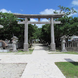
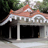
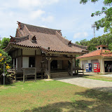
The Akainko Shrine

The Akainko Shrine


View Map It! Okinawa in a larger map
Akainko Shrine

      GPS
     LatitudeLongitude
     N 26 23.142E 127 44.432


The Legend of Akainko, the Father of the Sanshin

The story behind the Akainko Shrine is both a sad and happy one. The story dates back to the 15th and 16th century in an area now known as Sobe of Yomitan Village. It deals with hardship of a village life, a tale of love and death, and the triumph of one man’s legacy that would ultimately change Okinawa forever. The following tale is derived from the Yomitan Village Folklore and Legends publication.
The villagers were clinging to hope, but the drought showed no signs of ending any time soon. Fresh water had become scarce, and the townspeople where in much need of a miracle. It so happened that in the village there was a beautiful young woman by the name of Chira who had a pet dog. The two were always together and the dog was known for his brilliant red hair. One day, the dog disappeared, and when he returned, Chira had noticed something odd; the dog was soaked with water! “How could this be?”, she wondered, for there hasn’t been any rain for such a long time. The dog tugged on her clothes pleading with her. He obviously wanted to show her something; and so she followed him. He led her to a nearby cave and inside, she discovered the reason why the dog was wet. There was a spring inside! Chira ran back and told the villagers, and upon hearing the great news they extolled both Chira and her pet dog.

However, happiness was short-lived for the young woman. Chira had found herself in a vicious love triangle, and the situation was about to escalate; for she had made it known who she wanted, and this did not sit well with the defeated lover. He would eventually murder the man Chira loved, but it would not stop there. This was just the beginning of her troubles.(ii)

Devastated and heartbroken, Chira was now facing another reality: she was pregnant with her now deceased lover’s child. What was she going to do? She wasn’t married; and how was she going to explain this to her parents? Time went on, and it became obvious that she was bearing a child in her womb. Villagers began to question the ordeal and rumors circulated. It turned out, the man who killed Chira’s true love was the one spreading these rumors. To lay one more knife in Chira’s heart, he planted the idea that Chira had done the unthinkable. The father of her baby wasn’t a man. It was her dog.

If her dignity wasn’t destroyed then, it was now hanging by a thread. Humiliated and emotionally isolated, Chira had no choice but to leave the village. She fled to Ikei Island to live out the rest of her days.(i) There, she gave birth to a son and found some hope of a peaceful life, but that too was short lived. A few years later, her parents had found out where she was staying and decided to go see her. But after learning the news of their arrival, she became stricken with guilt for she had caused them so much pain. Ashamed and unable to face them again, Chira had taken her own life.

She left behind her parents, broken-hearted, and a son with an uncertain future.

Years later…

He was sitting around when it began to rain. Drops, one-by-one, fell to the earth making a nice thump-like sound. So pleased with the rhythm, the young man wanted to mimic what he had heard. He then took a branch from a Kuba Tree and took three strands from a horse’s tail and put them together to make a banjo-like instrument.(iii) The young man liked what he had heard and took his new invention and played it wherever he went.

One day, a servant of the king had heard the young man’s music. He was so pleased that he asked him if he would go to Shuri to play for his majesty. The young man agreed and together they set off to see the king. And so the young man played and played to his heart’s content. The king wasn’t just amazed. He was enthralled by its beauty and power; so much that he immediately directed the young man to travel throughout the island to spread his music. And so off he went spreading his love in musical form.

His adventures would eventually take him to China and on his journey back, he brought with him various types of grains and apparel he had found in his travels. The villagers of Yomitan took the grains, cultivated them, and spread them throughout village yielding many, many crops. It was from this day forward that Yomitan would become known as the 'King of Vegetables' throughout the kingdom.
Epilogue. Every year Yomitan Village celebrates the Akainko Festival typically held around 20 September of the Lunar Calendar to honor the young man’s legacy and the new staples he introduced centuries before.

Sanshin and Sanshi-no-hi (三線の日).The banjo-like instrument he created became known as the Sanshin, named for the three strings used to make the beautiful sound; and henceforth the young man became known as the ‘Father of the Sanshin’. Sanshin, in Japanese literally means ‘three strings’. Every year on March 4th, a special musical ceremony (mainly comprised of sanshin players) is performed in front of the Akainko Shrine to honor his musical contribution to Okinawa and to the world. This is no ordinary date. March 4th has become known as the ‘Day of the Sanshin’ or in Japanese, Sanshi-no-hi (三線の日). The reason March 4th was chosen is because numerically the date can be written as 3/4. The special date is based on a Japanese pun, where 'san', means 3, and 'shi', means 4 – the two syllables found in the word sanshin. It is not uncommon to see students of the sanshin praying at the shrine. It is believed it will help them master the art.

The Shrine and the Meaning of his Name. The location of the shrine is believed to be where the young man ascended into heaven.(2) His true name given at the time of his birth remains to be a mystery however. It appears that any knowledge of that went to his mother’s grave all those years ago on Ikei Island. So he decided to take on another name. In the Okinawan language he called himself Akanukuu (アカヌクー). In Japanese this translate to Akainko (赤犬子).(iv) If one where to analyze its kanji form, the meaning becomes clear. Put together it means 'Child of the Red Dog'.

Author’s Notes.
i. The above account was derived from Yomitan’s Folklore and Legends Publication, dated 2005. An older source mentions that Chira fled to Katsuren and lived inside a cave near the ocean. It made no mention of Ikei Island. The source was from a 1990 version of Yomitan’s History Chronicles #11, beginning on pg 220.
ii. Other sources describe a more chilling version of the love triangle that occurred between Chira and the two men involved. This is pending further research and investigation as this version was not mentioned in either of the above sources.
iii. The Kuba Tree is the Okinawan name for the Chinese Fan Palm, (Livistona chinensis). For images, visit Floridata.com.
iv. The first kanji (赤) means red (Aka); the second kanji (犬) means dog (Inu); and last kanji (子) means child (Ko). When the kanji’s are put together the ‘u’ is subtracted from inu.

Reference.
1. The Akainko Story, The Yomitan Folklore and Legends Publication, dated 2005, pg 39
2. Akainko's ascension, Okinawa Prefectural Board of Education. Website.

Directions/Parking. The Akainko Shrine is about 250 meters in front of the US Army Base Torii Station main gate. It is the turn-off immediate west of the Family Mart. Take Highway 58 into Yomitan and then take Highway 6 going west towards Torii Station. Torii Station will be on your left, the Family Mart to your right. Parking is very confined. Please do not block any gates belonging to any residential areas.

Sunday, September 29, 2013

"The Awase Bijyuru Shrine"

Entrance into the Awase Shrine


View Map It! Okinawa in a larger map

The Awase Shrine

     GPS
    LatitudeLongitude
    N 26 19.240E 127 49.991


The Awase Bijyuru Shrine

Origins of the Shrine. It is said that the shrine houses three special stones that washed on the ashore long, long time ago and when a woman found them they followed her home(1). The stones are said to represent the Fire Kami-sama or Fire god or spirit (1) and people to this day come here to pray for good health, good fortune, and for fertility. The shrine itself is referred to as the Bijyuru Shrine. The term bijyuru  (ビジュル)is of the Okinawan language. When there is a stone that is considered sacred or special, Okinawans refer to these kinds of stones as Bijyuru. Other Okinawans have said that the stones were able to float on the ocean which is what made them special and thus taken in by the villagers for worship.

Source of Information.
1. Okinawa; A People and Their Gods, James Robinson, 1969, pg 57

How to get there? The Shrine is in Awase just off Hwy 85. There are two good landmarks to help guide you in. If you see the map above, you will see a San-A store and the other is an AU cellphone shop.The shrine is not so visible off Hwy 85 cause it is surrounded by trees.

Parking. There wasn't any signs that I could tell that were designated parking areas. There was one for a big restaurant next door. Park at your own risk. There is a small kids park next to the Shrine, so if you want to stop there to have a lunch box feel free. Bring water, camera, and umbrella. Here We Go!!!

ENTERING THE SHRINE

Wednesday, July 11, 2012

"The Hakugin-do Shrine - Itoman City"

The Hakugin-do Shrine, Itoman City


View Map It! Okinawa in a larger map
Hakugin-do Shrine - Itoman City

     GPS
     LatitudeLongitude
     N 26 08.014E 127 40.202


The Hakugin-do Shrine - Itoman City


The Hakugin-do Shrine (or Hakugindo) in Itoman City is a very special shrine to the people of Itoman and its fishermen. A god referred to as Shirogane-no-oibe (God of the Sea) is enshrined here and it is to whom the Itoman residence pay homage to for a prosperous yield of fish, as well for a safe return from the sea. The shrine is also referred to as "Yoriage-utaki" and the area around the shrine is said to house graves of local fishermen that once lived in the area long ago. 

The exact date of the shrine's origin is not exactly certain. If local legends are true then it could possibly date back for centuries. But an “impressive” structure was later built in 1933, according to the book, Okinawa; A People and Their Gods, published in 1969. However, it was later destroyed in the aftermath of the Okinawan Battle. Travel writer, Michael R Lynch, shows Then-and-Now photos of the post-war structure taken around 1958 and a more recent photo taken in 2012. The author of the aforementioned book also tells of a story that long ago a young wife of a king (name & date not mentioned) once came to this shrine to pray for a son. Her wishes had come true, and subsequently, it became a custom for new wives wishing for a son to come here to make their wishes known.

Legend of Hakugin-doPerhaps a more intriguing legend is now being circulated. This folklore is referred to as the “Legend of Hakugin-do” in which the story tells of act of mercy shown by a Samurai towards an Itoman fishermen. The enshrined cave had became the focal point throughout the story and later, a symbol of their friendship. A YouTube video taken by a blogger, Tom Corrao, shares this video posted on his blog, Okinawaology. In the video, a tour guide describes the details and circumstances surrounding this legend.

Author's Note. According to the Itoman City Official Website, a large rock, referred to as the 'God Rock' sits at the south end of the shrine, however it wasn't certain which actual rock the website was referring to.

Directions. The Shrine is in Itoman City. It sits along Highway 331 (left if you are going south). Look for the Torii Gate to the side. Note. There is Highway 331 and there is the 331 Bypass that split near the Naha Airport. Study the map carefully. If you are going south, take the Bypass by continuing straight rather than turning right as if you are going to Senega Jima. You will then come to a traffic intersection where 3 Highways begin (Highway 231, 68, & 331). Take the 331 south. About another 4.5 km the shrine will be to your left. You will cross over a very noticeable river stream about 400m before you reach the shrine.

Parking. Parking is available. The parking entrance is just before the Torii Gate (north of the gate). See picture for details. Note: The Shrine will mostly likely sneak up on you, since the Torii is tucked in from the road.

Source.
Book: Okinawa, A People and Their Gods, James C. Robinson, Tuttle Publishing Company, 1969.
http://www.city.itoman.okinawa.jp/section/syoukou/page3/play.htm

Tuesday, June 26, 2012

"Mystery of the Bumagongen Shrine"

Steps leading to the Bumagongen Shrine


View Map It! Okinawa in a larger map
Bumagongen Shrine - Nago City

     GPS
     LatitudeLongitude
     N 26 36.431E 127 54.051


The Bumagongen Shrine – Nago City


It is quite possible to live on Okinawa for many, many years, drive along Highway 449 a hundred times, and still never notice this very well hidden elaborate and mysterious shrine. This sacred grove sits on a isolated hilltop near the Motobu and Nago border well camouflaged by an unusual surroundings of rock quarries and giant machines that mask what should be a very visible and conspicuous shrine seen from the highway. This is the mysterious Bumagongen Shrine – Its origin may be as puzzling as its place and location.

Information provided by the Nago City Museum did reveal that the shrine may have been built some time during the Meiji and Taisho Period (1868-1926). It was during this time that various industries had faltered and the shrine was believed to help provide prosperity and to bring life back to the community. Originally, the sacred ground was only one tsubo in size (equivalent to two tatami mats). Reconstruction from September 5th, 1925 to its completion over a year later on December 7th, 1926 expanded the shrine's area. Ironically, though the shrine was meant to bring prosperity, the community that once thrived in that area is no longer in existence, and any legends and stories about the origins of its enshrined 'kami' or god may have been lost with it.

The architectural style was considered unique for its time. Two masonry craftsmen from Ogimi Village was said to have assisted in its renovation. However, the list of donors that aided in its reconstruction can no longer be found. In 1985, the Bumagogen Shrine celebrated its 60th Anniversary of its reconstruction, and from all accounts, still stood as it did many decades ago.

The cave. The cave is presumably where a 'kami' or god is enshrined. It sits in the rear of the stone structure. It is fenced off and not permissible for entrance.

Directions. If you take Highway 449 along the coastline going north look for a large mill-like structure to your right (Landmark icon designated above). Take the first right after you pass this Landmark. From there you should be able to navigate your way to the shrine entrance. It is roughly 600 meters from Highway 449. The torii gate will also be visible from Highway 449 if you look behind and to the right of the mill.

Notes.
1. Meiji Period (1868-1912), Taisho Period (1912-1926)

Thursday, December 8, 2011

"Sumiyoshi Shrine in Yamashita, Naha City"

Sumiyoshi Shrine of Yamashita, Naha City


View Map It! Okinawa in a larger map
Sumiyoshi Shrine of Yamashita, Naha City

     GPS
     LatitudeLongitude
     N 26 12.237E 127 40.029


Sumiyoshi Shrine in Yamashita, Naha City


This is the Sumiyoshi Shrine of Yamashita in Naha City. It's a small beautiful shrine decorated in bright orange that rests on a ridge-side near the Naha Port. Poor legibility and difficulties with some of the advance Kanji on the shrine's stone marker made it difficult for an accurate explanation of its origin. Further research is required and will update the post accordingly. There are a couple of shrines named Sumiyoshi in mainland Japan, and thus there could be a possible connection. What is known is that the shrine gives homage to 8 important figures. Some were to gods and some were of people. As you can tell from the picture above, there are 8 stone placards marking the names of a god or person. Some of the gods were those that represented the Dragon, Fire, and Land. Some of the other placards had suffixes that gave reference to a person, but the Kanji names could not be easily deciphered. This is a small simple shrine, but it does blend in with the natural beauty with the ridge-side greenery and because it is less visited, you may find a more sense of tranquility and peace than you would at some of your more high profile shrines on Okinawa.

Caution. Once you are at the main shrine area you will see an extra set of steps leading upwards into the hillside. This eventually takes you to a trail that leads you to the very top of the ridge. However, in order to get to the top you have to climb a muddy and slippery slope. There is (was?) a makeshift rope to help you climb. However, I highly recommend you don't climb it. The slope is very slippery, the rope is severely worn, and there are some rocks you can hurt your knee on. THERE IS ANOTHER WAY TO GET THERE BY CAR. At the top is Gajyanbira Park. Scroll to the left on the map above and you will see a vehicle route to get to it. At the edge of Gajyanbira Park, you will find a monument giving tribute to perhaps one of Japan's most famous singers. Her name is Hibari Misora

Getting there. It is not too difficult to get the shrine, however, if you are not alert you will miss the turn-off completely. The only practical way to get there is by going on the southbound lane of the 331. As you just hit the Onoyama Park/Dome you will notice that the 331 splits into two. The right lane takes you on the 331 By-Pass on-ramp and the left most lane is the main 331 that skirts the Yamashita District. DO NOT GO ON THE ON-RAMP. STAY IN THE LEFT MOST LANE. Continue straight. You will pass one major intersection (Highway 7). As soon as you pass this you will see an ENEOS gas station to your left. Turn left as soon as you pass this gas station. The left turn is immediately after the gas station. See the blue designated route. Park near the lower park. You will a set of bright orange stair rails. That will lead you to the shrine.

Other places of interest nearby: Tribute Monument to Hibari Misora, Pineapple House of Naha City, Manko Waterbird & Wetland Center, Fukushuen Chinese Garden.

Sunday, November 27, 2011

"The Futenma Shrine and Cave"

The Main Hall of the Futenma Shrine


View Map It! Okinawa in a larger map
Futenma Shrine and Cave


     GPS
     LatitudeLongitude
     N 26 17.572E 127 46.624


The Futenma Shrine and Cave


The Futenma Shrine is considered one of the major Shinto Shrines here on Okinawa. Many people come here to pray for various reasons, mainly for good fortune. It is accessible to all, but perhaps to get the most and best experience from visiting this shrine, is to bring a Japanese or Okinawan friend along with you. Having someone familiar with the customs can guide you through some of the traditional practices when attending such a sacred place. This might also be their first time attending this particular shrine as well. If you do go without any knowledge of the customs, just show proper etiquette as you would at any sacred place.

There are few simple things that you can do however. When you first enter go through the Torii Gate, give a slight bow as you enter. The Torii Gate symbolizes an entrance to a holy ground. Next you want to go to the 'purification fountain'. They have a pictorial demonstration board posted next to the fountain. Please go to this link of the “Awase Shrine” and go to the section called 'Steps to Purification'. The process is same.

When you go to the main hall, you will see an offertory box. It is not required, but if you wish to make an offering (10 or 100 yen is okay) you can do so. Once you drop your offering you bow twice then clap twice (quietly), then bow once again. Some people just bow and clap twice. Different sources may vary. You can also read the section called “How to Pay Reverence at a Shinto Shrine” here.

The Story. The office at the shrine does have an English write up of two legends pertaining to this shrine. Ask for one when you go there. The first legend is about a female deity or 'kami' named Megami. The legend goes as follows (paraphrased): there where two sisters that lived in area called Syuri. There were rumors that the eldest sister was a very beautiful women, but because of her devotion to spirituality, she had no desire to be seen in public. Her younger sister's husband wanting to see what she looked like took a peek. Realizing that she had been seen, “the older sister rushed out of the house in agony and into the cave, never to be seen again”. Since then, she had become a deity of the cave (quote was taken from that English write-up).

The second legend is about a male diety or 'kami' called Kumano. Legend has it that there was once a humble couple that lived in poverty many, many years ago in Nakagusku-son, not too far away from modern day Futenma. Because of their dire circumstances, the couple agreed that the wife work as a royal maid at Shuri Castle. Every evening after work, the wife would leave Shuri Castle and make the long journey to the Futenma Shrine to pay her respect. Then one day, the Kumano Kami, disguised as an old mountain man, visited the poor woman near the Futenma Shrine and gave her an item that was wrapped . He told her to hold it for him. Time went on and he had not reappeared for some time, so she prayed. One night he appeared to her in a dream and revealed who he was. He then told her that the special item was hers to keep as a reward for her perseverance. She then opened up the item and it discovered it was gold. Since then, the couple became prosperous and wealthy. Henceforth, people have become more devoted to the shrine.

Photographs. If you wish to take photographs of the main hall, please do so quietly from the outside looking in as to not create any disturbance inside. People go in to meditate and to pray. Sometimes there will be a prayer session going on. Avoid taking any photographs while inside the main hall sitting area, unless given special permission.

The Cave. You have to be granted permission to enter the cave. This is not difficult, however, you do have to ask. They will escort you in. This is a controlled environment and there is limited space in the cave so you may have to wait. If you can, please have a Japanese friend come with you to help explain some of the things you will see. I think you will get more out of this experience if you do so. If there is a special ceremony inside the cave then it may be closed off to the public at that time. Pictures are allowed inside the cave but please do so without creating any major disturbances. Please maintain a low voice and a sense of quietness at all times as you enjoy the peace. You are on sacred grounds.

Getting there. Getting there is not difficult. The shrine is just south of Camp Foster and Camp Buckner. However, the turn-off will sneak up on you. You can only enter when you are driving in the north lane of Highway 330. There is a middle divider blocking you if you are driving south. When you do turn off, it may not be apparent where you are supposed to pull in. There is a driveway to the right of the Torii Gate as you are looking at it. Drive through there and it will take you to the parking lot. Parking is free.

Thursday, November 3, 2011

"The Sueyoshi Shrine of Naha City"

The Sueyoshi Shrine of Naha City


View Map It! Okinawa in a larger map
Sueyoshi Shrine

     GPS
     LatitudeLongitude
     N 26 13.804E 127 42.846


The Sueyoshi Shrine of Naha City


This commanding structure is the Sueyoshi Shrine. It lies prominently high at the Sueyoshi Park of Naha City and can also be seen from a distance at the grounds of Shuri Castle. The path to get there can be quite a trek depending where you start. You have several options however. Please see the post on 'The Sueyoshi Forest Park' for detailed instructions on how to get there and where to park. Around the shrine itself is a network of trails, burial tombs, and sacred prayer sites interspersed along the hillside. If you visit, chances are you may see families or Holy people paying their respects along these trails. If you happen to walk upon such a private gathering, just keep a  proper distance or avoid it all together and you should be fine. It is understood that people come to see the main shrine itself.  A sense of quietness should be maintained at all times as you enjoy the tranquility of nature and peace that accompanies the area.

The shrine's origin can somewhat be explained by a stone marker along the path that was also translated in English. It reads...
The Sueyoshi Shrine, commonly called 'Shadan' was a guardian shrine of the Taikei-zan Manjuji Temple. According to tradition, the Kumano Gongens (Shinto Avatars) were enshrined here during the reign of King Sho Taikyu (1454-1460).
The stairway laid with Ryukyu limestone leads up the stone to the main shrine. The main shrine, one of Japan's National Treasures before World War II, was entirely destroyed during the Battle of Okinawa in 1945. The site is a place of scenic beauty as well. The Shrine  building was restored in 1972.
March 1990
Okinawa Prefectural Board of Education,
Naha City Board of Education.  
The explanation does give insight to its origin but also gives rise to more questions about the details. For example, the only reference I could find about the Manjuji Temple was of a Buddhist Temple in Kyoto, Japan (see source). So being very far away from the Ryukyu Kingdom, it is not sure what is meant that the Sueyoshi Shrine (a Shinto Shrine) was considered a  'guardian shrine' of a Buddhist temple, if this is indeed the temple. This may give insight to somewhat of a complex, yet compatible and peaceful integration of both the Shintoism and Buddhism as religion was becoming more and more popular in old Japan. Perhaps it is important to understand the human aspect of the Japanese people and the context of those times as well as religion was being spread throughout Asia. 

More information on the Sueyoshi Shrine can also be found  here.

Reader's Note. There are two buildings to this shrine. One lies behind the other. I am not sure of the particular significance one has over the other. Also keep in mind that some of the stone paths are uneven, so please watch your footing as you walk,.. and recommend avoiding any unbeaten side trails if you encounter them.

Other places of interest nearby: The Sueyoshi Forest Park, The Tomb of Ginowan Udun.

Friday, October 7, 2011

"Agami Shrine in Ginoza"

Agami Shrine in Ginoza


View Map It! Okinawa in a larger map
Agami Shrine in Ginoza

     GPS
     LatitudeLongitude
     N 26 28.598E 127 58.433


Agami Shrine in Ginoza

This is the Agami Shrine in Ginoza (also known as the Machougama Shrine). It is not too far away from Highway 329 and the Okinawa Expressway (Exit 9). To be honest, difficulties in the translation for this site had delayed early submission of this post. There were nuances that made it quite difficult at first. But after much discussion with various locals, I think the below translation best describes the origin of this shrine.
The Agami Shrine in Ginoza (Sokei District) (Shrine, Machougama Utaki)

The tree area surrounding the Agami Shrine in Sokei is believed to be where the  ancestors (Sokei or Ginoza?) first came from. Near this shrine, there were old houses and lots. With Agami hilltop in the center, new houses started to build apart from the old ones toward the shore. Long ago during a festival, a Noro (shamen), a female playing a role of a god dressed in white, would pray here for rich soil during harvest season.

During World War II, part of the 'spirit' from the Naminoue Shrine in Naha was taken and placed in the Agami Shrine in Sokei so Okinawans from that area could pray for safe return from the war*. Later, Agami Hilltop was designated as a shrine.  Agami Hilltop has the characteristics of Yanbaru (Northern area of Okinawa) with oak and old trees which is covered with abundance of greenery (woods).

(Sokei Journals) March, 2006. Village, Board of Education

*It is important to note that some Okinawan men were directed to fight for Japanese Army during World War II.

Some of the difficulties with the translation were related to the different contextual meanings of a word. For example, in the Japanese version of the inscription, they used the Kanji 'Yama', which to many foreigners is mostly understood as a 'mountain'. But 'Yama' could also mean 'peak' or 'hill'.  The Agami shrine is built on a hilltop and from there the elevation does decline to the shoreline. At first this is not obvious due to the surrounding buildings. But once we made the connection from 'Yama' to 'hilltop' the more and more it began to make sense. The above translation does lead to another question of religious protocol; How does a spirit or portions thereof go from one shrine to another? I am sure there is a ceremony of some sort. It is yet another item of a long list of items of Okinawa mysteries that I hope to solve.

Monday, August 22, 2011

"The Mysterious 'Meinu' Utaki - Awase's Birthplace?"

'Meinu' Utaki in Awase, Okinawa


View Map It! Okinawa in a larger map

Meinu Utaki in Awase, Okinawa

     GPS
     LatitudeLongitude
     N 26 19.139E 127 50.147


The Mysterious 'Meinu' Utaki

This sacred place, or 'utaki' is found in Awase, Okinawa. It is called the 'Meinu Utaki'. According to the translation from the stone inscription right next to it and from the town office brochure. People at one time immigrated from the Shuri province to the island of Awase in the 18th Century. They would pray at this utaki for good fortune and luck as they embarked on their new life here at Awase. The stone inscription (see album) starts with the heading 'Mae no Utaki'. 'Mae' usually means in front of. It also has the meaning of 'before'. Putting the pieces together as best as possible, I think what the stone is saying, that "This is a Sacred Place from Long Before". Translation is often tricky and difficult. Even the local Japanese and Okinawans may have difficult translating the Kanji, since even a Kanji may have several meanings.

Why I use the word 'mysterious' is that according to the translator, the inscription says that the people immigrated to "The Island of Awase". Parts of modern day Awase might have been at one time an independent island. I didn't know that. Since then, it perhaps was built up over time and connected to the mainland. Doing a Google search I was not able to find another source to accurately confirm this. This adds to another long list of mysteries of Okinawa history. According to the translator, the sacred place marks the center of the old Awase Island, hence why it could be considered the birthplace of modern day Awase.

(Update, August 25, 2011: Here is literal translation of the inscription.

Awase was once known as the "Ase Island," "Awasu Kubanari," which was a desert island.  However, during the King Sho Boku (1768) era, people from Shuri, Naha started to move here and became a village. The origin of this stone is when the island people thought about building a shrine to worship and pray for the prosperity of the village.This coral-lite based structure has been withstanding over 200 years of wind and rain and is known to be the oldest place of worship. The shed was added later in 1997 to protect this stone from wind and rain.

August 31, 2001
Awase Restruction Committee)

Directions. If you follow the blue route that takes you to the Awase Shrine and continue on, you will eventually find some side streets that would lead to the location. You may have to count the streets to figure out which lane to turn on.

Parking. You should be able to park off on the side somewhere nearby.

What to bring. Definitely a camera. There are other areas nearby that have yet to post due to translation confirmation.

Other places nearby of interest. The Awase Shrine, The Awase War Memorial, The God of Fire Utaki, Kanomou Well, Ubugaa.

Wednesday, August 17, 2011

"Yomitan War Memorial - Tokeshi District"

Yomitan War Memorial - Tokeshi District


View Map It! Okinawa in a larger map

War Memorial Shrine in Yomitan

     GPS
     LatitudeLongitude
     N 26 25.256E 127 43.635


Yomitan War Memorial - Tokeshi District

This War Memorial in Yomitan may go unnoticed if you never veer off the main highway (Route 6). We found this shrine by literally getting lost in Yomitan. This particular war memorial resides at the Tokeshi District of Yomitan Village. It sits underneath a large tree (See picture album above). Next to the shrine are the list of names from Yomitan Village who lost their lives during the "Greater East Asia War". This term was used by the Japanese to describe World War II.

There are two war memorials in Yomitan. This one at the Tokeshi District is older. It was built in 1913. At  this moment, I do not have the location of the other war memorial.

Parking: You will have to find a place off the road. Park at your own risk.
How to get there: Please look at the map to do a route reconnaissance. Although you can use Hwy 6 to get close to it, you do have to navigate your way through some unmarked roads. It's not too difficult. I provided some landmarks near the shrine.

Other places of interest nearby: Statue of Shinran Shonin.

Saturday, August 6, 2011

"The Park of Mysteries - Toguchi Village"


View Map It! Okinawa in a larger map

The Park with Many Mysteries

     GPS
     LatitudeLongitude
     N 26 18.222E 127 48.495


The Park of Mysteries - Toguchi Village

I call this 'The Park of Mysteries'. It is tucked away in Toguchi Village, just south of Awase. It is pretty hidden and not something you will see advertised on the main highways. It is in the northwest corner of the 81/329 Intersection. I call it 'The Park of Mysteries' cause there were a few structures of curiosity that had no explicit explanation or inscription next to them (PLEASE CLICK ON THE PICTURE ALBUM). The park is well kept which means someone must take care of it. I suspect that local volunteers in the village help with the maintenance.

Mystery #1. There is this well structure with no inscription on it explaining its purpose. The well is only about a foot deep filled just with rocks and overgrown vegetation. I am not sure if this was a source of water at one time. (It is important to note that this structure may have no importance whatsoever. Someone could have just designed and made it that way). It looks relatively modern.

Mystery #2. There is a pond with a what used to be a large tree hanging over it. The pond is now just stagnant water. But it flows to a nearby ditch. I am not sure if this was a spring at one time. The tree has been cut up for some time, and the only part that remains is a big chuck of its trunk. It looked like the tree was really big at one time and had some importance at one time.

Mystery #3. There is a stone that erected next to a tree. It doesn't look like an ordinary stone. It almost looks like it was put there on purpose. No inscription was next to it. Part of the stone was broken. Again, it could be a coincidence that that stone happen to be there and shaped the way it was, but I don't think so.

Mystery #4. Behind the park is a trail that skirts around to an 'Utaki' (Hogan, the Okinawan native language, for sacred place). There is an inscription with a heading that says 'Kumishi' in Katakana (Katakana is Japanese alphabet for non-Japanese words). Asking around, it is not certain what this means. It could be a Hogan word. Hogan dialects vary on the island as well. So an Okinawan from one part of the island may not know a Hogan word from another part of the island. Below the heading it says, "Birthplace at Atta Village". I believe that the utaki was created at Atta Village which is in Onna Village (opposite side of the island) and that it was later moved to Toguchi Village.

My goal is to go back and find an elder from Toguchi Village that may know about these curious structures.
I will come back and update this post on my findings.

Other places of interest: You will see a set of steps from bottom of this park. If you take it up and veer right, you will run into 'Midori Park' or 'Green Park' about 100 meters away. You will also see another War Memorial (Toguchi War Memorial) at the entrance of Green Park. I will blog about this real soon.

Caution: Just be aware of low lying branches. You may see some of those big Banana Spider webs, particularly if you going on the trail to the mysterious utaki in the back. I wouldn't wear sandals. Wear some good shoes, especially if you decide to go to the 'Green Park' afterwards. 'Green Park' has some interesting side trails, but they are rugged. If you do go to 'Green Park', definitely watch out for the Banana Spiders. 'Green Park' is also built on a slight incline, so it is a little workout going through it.

Parking. Look at the Green thumbtack in the map. Parking is tight. Keep in mind that the village next to the Mysterious Park has some very narrow roads if you try to go through by car (You shouldn't have to though). Toguchi Village is an Old Okinawan style of neighborhood. To access the Mysterious Park, you could do what I did and park somewhere near Highway 329 or 81 and walk to it.

What to bring. Umbrella for shading, rain, and removing spider webs. Definitely bring water and a camera. Bring a lunch box if you think you will be there for a while. It's good for a quiet picnic.

The Mystery Park of Toguchi is a small park, but it is quiet and serene. It's good to relax and just take a small part of Okinawan culture.

Tuesday, July 19, 2011

"Shrine in Kin"

Kin Shrine (Kin Kannonji Temple)


View Map It! Okinawa in a larger map

Shrine in Kin

     GPS
     LatitudeLongitude
     N 26 27.300E 127 55.288


Kin Shrine (Kin Kannonji Temple)

I lived in Kin for many years and I always drove passed this place and never saw it. It is not really promoted very well and maybe that is the way the want it. It is a religious site so it is considered sacred among the Okinawans. But you almost have to really look for it or you will pass right by it.

There is a parking area right across from it. I DON'T READ JAPANESE...but I am pretty sure its for the temple. Park at your own risk.

You will see the temple or shrine straight ahead as you walk down. There is a tourist office immediate to the right. That is where you pay an entrance fee for going in the cave itself.

It is 400 yen for adults, 300 Yen for students, and 200 yen for children (not sure what the age limit is).

Okay, about the cave...it is somewhat dark and slippery. They do have lighting. If you are gonna bring a camera, then bring your own flash just in case.

If you are gonna bring children I recommend them to be a little older. You don't want to be carrying a baby down there or even a 2 year old. They do have hand rails as you go down and up the entrance stairway, but the steps are rather awkward. It's not playground basically is what I am saying.

Water tends to drip from the ceiling, so just be aware. It may be a little slippery.

They store sake in these caves. You can have this done in your name, but I am not sure yet how that works. I will try to find and repost again in this blog. I gather there has been sake bottles stored for years.

I don't know the hours, but I imagine they do not open at night. It might be kind of dangerous so maybe that is why. Please keep in mind this is still a religious site and should be treated with respect and a sense of quietness.

Other Things to See in the Area: Oshiro Kozo, O-Kawa, Richamocha Cafe, Kin's Castle Rock, Kin Watch Tower, The Gold Hall, Kinjo's Used Goods, Kin Town's Hidden Nature Trail, Statue of Toyoma KyuzoBirth Place of Toyoma KyuzoKin Town's History Chronicles, Kin Town's Cherry Blossom Way.