Search Map It! Okinawa

Showing posts with label cave. Show all posts

Sunday, March 16, 2014

Yamagawa Kakiuchi Gongen Cave

The Yamagawa Kakiuchi Gongen Cave


View Map It! Okinawa in a larger map
Yamagawa Kakiuchi Gongen

     GPS
     LatitudeLongitude
     N 26 40.749E 127 53.076


Yamagawa Kakiuchi Gongen Cave

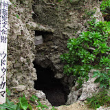
Near a small inlet in the town of Yamagawa off the Motobu Peninsula lies a small cave called the Yamagawa Kakiuchi-Gongen Cave. Local villagers here refer to her as Hachinuchigunjin (meaning uncertain).(1) The kanji for the formal name, Kakiuchi (垣内), does give reference to a 'fence within' but its metaphoric interpretation is unclear. What is known, however, is that the cave is considered to be on holy ground. Excavations also have unearthed pottery and relics believed to date back between the 10th and 12th Century.(1,2,3) 

The term Gongen. The suffix term, gongen can trace its roots to both Buddhism and Shintoism. The term essentially describes an avatar-like being.(4) More thoroughly put, gongen is simply the manifestation of Buddha in human form. This term, however, was used under the auspices of Shintoism under the concept of honji suijaku, a belief that Buddha deities can appear as kami's (Shinto deities).(5,6) Though not all Shintoist shared this belief, the concept evolved perhaps at a time when Buddhism was becoming more and more popular in Old Japan, where Shintoism, the indigenous and more dominant religion at the time, was losing favor to Buddhism. In essence, the concept was a way to harmoniously combine the two religions without Shintoism losing its legitimacy (author's speculation). This harmonization became known as shinbutsu shûgô.(7) This assimilation movement was later abolished by the Japanese government on March 28, 1868 during the Meiji Restoration in what became known as shinbutsu bunri, the separation of Buddhism and Shintoism.(8) As for the Yamagawa cave in Motobu, it is not clear what connection exist (if there is one to begin with) between either religions or why it received the title of Gongen. This is pending further investigation.

Recommendations. Though the cave is extremely small it is still considered sacred and continues to house burial urns. Entrance is highly ill-advised. Additionally, the entrance is extremely narrow and any attempt to enter my cause damage to the cave. Any geocaching activity (physical emplacement of an object) should be avoided in the immediate area.

References. 
1. Motobu Town Website Site ( Yamagawa Kakiuchi-Gongen).
2. Cultural Assets of Okinawa, Education Commission of Okinawa Prefecture, March 31 1975, Pg 125
3. Gusuku Period, Okinawa Prefectural Education website.
4. Gongen; definition, Encyclopedia of Shinto, website link.
5. Honji suijaku;  definition, website link.
6. Maitreya, the Future Buddha: Edited by Alan Sponberg and Helen Hardacre,CUP Archive, 1988, pgs          251-252, Google Book Link.
7. Shinbutsu shûgô; definition, Encyclopedia of Shinto, website link.
8. Shinbutsu bunri; definition, Encyclopedia of Shinto, website link.

Directions. Take Highway 58 into Nago City. Then take Highway 449 going towards the Motobu Peninsula. Then take Highway 114 as if you are heading towards the Churaumi Aquarium. About 400 meter after making this turn you will turn left at this LandMark (Group of Signs). Follow the blue designated route to till you reach this dead end. The cave will be next to this LandMark.

Thursday, October 24, 2013

The Cave of Dances

Uduigama


View Map It! Okinawa in a larger map
Uduigama, Onna Village

     GPS
     LatitudeLongitude
     N 26 30.109E 127 50.676


Uduigama, Onna Village

Not far from Cape Manzamo, you will find a small seaside cave that is called Uduigama. The term udui (ウヅイ) is of the Okinawan language meaning to dance(i). The term gama is also Okinawan for the word cave. Loosely translated, Uduigama means the Cave of Dances. Long ago, nearby villagers would use this cave to practice kumiodori dances(ii) in preparation for the August Mura Ashibai Festival.(1)(iii) It is said from August 1st to August 10th of the Old Calendar (Chinese Calendar?) that the cave was used by the participants as a place for practice and preparation, and on the first day of the August Mura Ashibai, all the participants would start from this cave, led by their leader (a flag bearer), and take part in a michijune, (a street parade). (1)(2)

Today, formal practice sessions are no longer held inside the cave. However, on the actual day of a Mura Ashibai, an opening ceremony is still performed at the cave as a dedication offering.(2) From time to time, villagers may still use the cave as a place for prayer or to conduct traditional dance sessions for special occasions, and throughout Okinawa, you may find other caves that villagers have dubbed generically as an uduigama. If so, more than likely it gives reference to a special dance ceremony that once took (or currently takes) place inside the cave.

Cultural Sensitivity. Please show reverence as you enter the cave. If you happen to stumble upon a special ceremony please maintain a respectable distance unless given special permission to do otherwise. Please note that some Okinawans during spiritual ceremonies may not like their photographs being taken.

Author's Notes.
i. Udui is slightly similar in pronunciation to its Japanese counterpart, odori (おどり,踊り).
ii. Kumiodori is a Okinawan theatrical style of dance
iii. Mura (ムラ) is the Okinawan word for village, and Ashibai or Ashibi (アシバイ or アシビ) is Okinawan meaning 'gathering'. In translation, the August Mura Ashibai means the August Village Gathering.

Reference(s).
1. Onna Village History and Culture Publication dated March 2000, published by the Onna Village Office
2. Onna Village historical sign on locations (translated in English)

Direction. Uduigama is in close proximity to Cape Manzamo. To get to Cape Manzamo take Highway 58 to Onna Village. You will see signs directing you to Cape Manzamo (Please view the map above). Once you arrive at the Cape Manzamo parking lot, look for a sign marker to your left as seen here. It will have the name Uduigama on it. You can take your vehicle all the way to the cave, though the lane will be somewhat narrow and parking will be tight. You will see an Onna Village Office sign off to the right that gives the cave's history. Note. On the map it appears you can take another road to the cave. This entrance is actual gated off.

Other places to visit nearby. The Onna Gusuku and the Hamasaki Utaki, Cape Manzamo (Sunset).

Friday, August 9, 2013

"The Matsuda Caves & the Mēgā Gama Ruins"

The Matsuda Caves & the Mēgā Gama Ruins


View Map It! Okinawa in a larger map
The Matsuda Caves & the Mēgā Gama Ruins

     GPS
     LatitudeLongitude
     N 26 29.648E 127 59.591


The Matsuda Caves & the Mēgā Gama Ruins

This article is being reposted with up-to-date information. The Matsuda Caves are now open for Guided Tours (Reservations only). Please read the entire article before going. A 'How-to Guide' on how to make reservations is linked below.

For many years, the villagers from the quiet town of Matsuda, Ginoza (long ago called Kocha) have known about one of its most precious natural wonders. Up to now, it has been one of the best kept secrets on Okinawa for a very long time. Everyday, hundreds and hundreds of transients drive along Highway 329 passing this very special and sacred place, unbeknownst to them that a very large cavern sits just 200 meters away from the main road. One shouldn't be surprised that even villagers from the adjacent districts of Nago City and Kin Town, (and from some areas of Ginoza Village outside of Matsuda) are aware of these mysterious undergrounds that have stayed hidden close to home for decades – possibly centuries. Welcome to the Matsuda Caves and the Mēgā Gama Ruins of Ginoza Village.

History. Local villagers have long regarded the Matsuda caves for its precious source of water. Even today, water streams through the intricate networks of tunnels that lie beneath the Matsuda underground. Researchers have found inside artifacts, such as pottery and shells, that date back to the Gusuku Era of the Ryukyu Kingdom. And like most caves during the Great Okinawan War, the Matsuda caves were a sanctuary for many during this very dreadful period. The caves were not only a safe haven for local villagers. Okinawans from other areas, to include the shimajiri region (southern part of the main Okinawan island), sought refuge here. A woman, now a Kin Town resident from the Namizato District, recalls seeking refuge in these caves when she was a child during the 1945 battle. Speaking with the official planners from the Ginoza Office, it is believed no one died in these caves during that time. However, there is no doubt that the elders of Matsuda have had series of long and dark memories surrounding the war and these caves – but there is one cave legend they are proud talk about.(1)

The Serpent & The Buddhist Monk. The main cave (picture above) is part of the Mēgā Gama Ruins. , according to the villagers, is of an Okinawan dialect that means before or in front. Ga means stream. Loosely translated, it means the river in front. In this case it is the river in front of Matsuda Village. Long ago, villagers feared going near this cave because of a very large serpent they believed that lived inside. Desperate, the villagers had asked a Buddhist monk from Shuri to help rid them of this menacing snake once and for all. Shortly after, the snake had mysteriously...vanished. The villagers have longed believed it was the monk's prayers and and his chants that 'exorcised' this slithering 'demon' from their midst. The monk would later go on to marry a local woman and spend the rest of his life in Matsuda village. His grave was put near the cave as a memorial to his contribution to the people of that town. His actual remains have since been relocated, but remains of his original tomb still sit near the cave. His remains are now located inside the worshiping house that sits up top.(2)(3)(4)

The Kushi Utaki. You may notice that behind the main worshiping area is a concrete utaki and behind that is a large hill. That entire hill is referred to as the Kushi Utaki. Villagers paid homage to this sacred hill for protecting Matsuda Village from strong winds during typhoons. The word 'Kushi' is also of the Okinawan language meaning 'behind'. In this case, it is referring to a sacred area behind Matsuda Village.(5)

The Cave Network. It is believed that throughout Matsuda Village there are other caves that have no cave openings. This has become a problem in the event new building are to be erected. A thorough land inspection has to be conducted before any new buildings are to be put up. It is said that during the war, there were 11 cave entrances where Okinawan hid for safety. Many of them have since collapsed.

Author's Notes.
(1)Gusuku Era can be considered as the 12 century but currently cannot cite an official reference that clearly defines the time period in question.
(2) No dates could be found when the 'Buddhist Monk' legend took place, but given that it involved a 'Buddhist' monk may shed some light on the time period when this legend occurred. The monk was also said to have traveled to the Kin Kannon-do Temple prior to coming to Matsuda Village, but was originally from Shuri.
(3) It wasn't clear if the bride was given to the monk as a sign of gratitude by the villagers. Some even say her residence was somewhere near or above the cave. This cannot be substantiated as of yet.
(4) Officials have said the remains of the Buddhist monk are now part main worshiping area.
(5) Sign near the Kushi Utaki in Japanese. Note that an Utaki which means sacred grove is also used to describe a small house-like structure where prayers are performed. But an Utaki could be a waterfall, large rock, and sacred grounds. Usually the house-like structure is just a focal point where prayers are offered, much like a crucifix might a focal point for prayer within a church for Christians.

Epilogue. For better or worse, the little town of Matsuda is about to change forever. When we first stumbled upon the cave over a year ago, it was agreed that it was something that could not be divulged to the public out of concern for public safety and that it would overwhelmingly alter the natural environment of the Matsuda town. Though the cave entrance sits 200 meters away from the main highway, there were no signs on the main road indicating its location, which lead us to believe that was done intentionally, and for understandable reasons. However, with the decision to make the Matsuda caves a public attraction, the decision was then made by the Ginoza Office to officially release the story; A Japanese magazine publication, called the Okinawa Graph, released its December issue on December 1st 2012 featuring the Matsuda caves and its location. Road signs are now being posted. Because of the safety restrictions that have been set in place and a previous released public announcement made, the planners said it was okay for us to release its location and to talk about the cave's history. To see 'before' pictures of the main cave, click on the photo album.

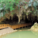
Guided Tours (Reservations Only). The Matsuda caves are now fenced up and safe for viewing from a distance. However,entering the cave is on a reservation basis only with the Ginoza Tourism Office. There are two main areas that will have guided tours. The boardwalk you see in the picture above goes in about 70 meters inside the cave. This is part of the Matsuda Village History Walking Tour (this is the only cave you enter for this tour). The other tunnel is about 240 meters long. The entire network, however, is believed to be about 800 meters in length, but many areas are too dangerous for passage due narrow channels and high water levels. 

>>>CLICK HERE ON HOW TO MAKE YOUR RESERVATION

Concerns and Recommended Areas for ParkingIMPORTANT! PLEASE READ. Keep in mind that this is a real village, and not a 'gated' attraction like 'Okinawa World'. Therefore, to help the people of Matsuda, it is highly recommended that you park away from anything that appears to be neighborhood road so as not to disrupt their daily life. Many still farm in this area. There is designated parking behind the 'Taiken Kouryu Center', (Green Thumbtack on the map) which will be the information hub and admission office for the caves. 

Furthermore, it will take some time for the people of Matsuda to get use to the number visitors it is about to have. The Matsuda people are a very proud and wonderful people, yet they are quiet about how they live their lives. Be respectful in mannerisms. A very quiet tone, a humble presence, a nice smile, and a 'konicihi wa' will go a long way.

Views on Caves. There is a stark difference on how non-Okinawans and Okinawans in general view caves. It is important to understand this. It is a difference between night and day. Please read Map It! Okinawa's Cave Disclosure Policy for background information.

Source of Information. Explanation signs on site (Japanese Only). Interview with Ginoza Tourism Office.

Directions. The turn-off to the Matsuda caves is about 500 meters south of the Highway 329 and Highway 234 T-Intersection in Ginoza Village. However, Highway 234 intersects twice with Highway 329. It intersects first in Kanna (south) and then again in Matsuda (north). Look for this large wood map board as seen in this picture for the turn-off. You will also see small white signs that say 'Taiken Kouryu Center' as seen in the same picture right hand-side.

Sunday, July 21, 2013

The Gohezu Cave

The Gohezu Cave


View Map It! Okinawa in a larger map
The Gohezu Cave

     GPS
     LatitudeLongitude
     N 26 43.403E 127 46.898


The Gohezu Cave, Ie Jima

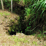
In 1975, explorers made a fascinating discovery on Ie Island in an area called Gohezu Yama (ゴヘズ山). It is here, inside a cave, that human remains were found dating back to the Paleolithic Era (between 2.5 million to 10,000 B.C). Specifically, these remains were thought to originate some time around 20,000 B.C. (1).

Deer Remains. It may be hard today to imagine deer ever existing on Okinawa, particularly on a small island such as Ie Jima. But in addition to the human remains, primitive tools made from deer bones were also excavated(1), suggesting that a species of deer either once thrived there or were later brought to the island. Today, you can find deer on the Kerema Islands of Okinawa, such as Aka Jima, where they are now protected under law(2). The question that obviously comes to mind is 'how did they get there?', and why were some islands inhabited while others were not. The mystery continues.

Interesting Semantics of the Kanji '山' (Yama). Most people have come to understand the Kanji and the word 'Yama', as a word meaning 'a mountain'. However, it is not clear why they refer this place as Gohezu-Yama (ゴヘズ山). When you arrive, clearly you will see no mountain that most people have come to conceptualize. The area is somewhat elevated if seen from a distance however. From its highest point, it sits above sea level at 82 meters(1). This confusion with the Kanji, '山', has come up before where local people's concept of the term 'Yama' varies. To some Okinawans it may be a piece of land that is elevated above the surrounding terrain, and not necessarily like a real 'tall' mountain like Mount Fuji in Japan. There may be a scientific reason that has dubbed this area as a mountain. Research brought us to a Japanese hiker's website in which the author set out to locate 'ultra-low mountains' (100 meters or less) that are identified in Japan's Yamana Encyclopedia (Japan's Mountain Encyclopedia). On the hiker's website, the Gohezu-Yama Mountain is listed as #26 of ultra-low mountains he has since located. (See website). Note. The Yaman Encyclopedia has yet to be reviewed for its contents on 'ultra-low mountains'.

Author's Notes.
1. The Gohezu Cave is barred from entry. Please do not attempt to enter.
2. The time period describing the Paleolithic Era may vary slightly depending on sources. It is sometimes referred to as the 'Old Stone Age', describing a period where the first humans made primitive tools out of stone. For more about the Paleolithic Time Period please visit http://archaeology.about.com.

Getting to Ie Jima. The Gohezu Cave is on Ie Jima Island. Please referred to Map It! Okinawa's Travel Prep to Ie Jima Island.

Directions to the Cave. The Gohezu cave is in close proximity to the Ie Airport Facility, which is identified in the LandMark Icon in the map above. There will be a turn-off on the opposite side of the main road that sits along the airport facility. It will be a dirt road as seen in this picture. Follow that straight till you see the cave explanation sign

Other Places of Interest Nearby. Niya-Thiya Cave, Ahashagama Cave, Statue of Asato Gura, Yuri Matsuri (Late April to 1st Week of May).

Source of Information.
1. History of the Gohezu Cave, Japanese sign on location, provided by the Ie Jima Education Office.
2. Deer on Aka Jima, Japan National Tourism Organization website.

Sunday, June 9, 2013

"The Tale of Two Caves - Ahashagama"

The Ahashagama Cave


View Map It! Okinawa in a larger map
The Ahasha Cave, Ie Jima

     GPS
     LatitudeLongitude
     N 26 43.610E 127 49.061


The Ahashagama Cave

June 22nd, 1945 – The Great Okinawan War' comes to an end. The day after, the long road to recovery begins.

June 23rd is a day of healing. It is Okinawa's Memorial Day, known to the Okinawans as 'Irei no Hi' (慰霊の日). The 22nd and the 23rd of June are two bookends of an era tied to a significant event. One is an end to a war-torn past. The latter, a beginning to a brighter future. This is Okinawa's past and with it, countless wartime stories told by the Okinawans – stories that did not always have a peaceful end. Telling them is their way of preserving the honor and memories of those who tragically lost their lives many, many years ago. Telling them is their way to remind us, the consequences of war. On Ie Jima, there are two caves that are connected by the Battle of Okinawa. One is about life, the other about death. Sen-nin Gama (now called the Niya-Thiya Cave) was said to have a 1,000 people take refuge in its domain as war waged on between American and Japanese forces. There were no reported deaths as a result of the war. And inside, you will find a stone about life. It's a fertility stone. Visitors to Ie Jima come here to feel a special power. To them, it is a 'Power Spot' and is pronounced as such in their own language.

Then, there is the Ahashagama Cave. It is a cave that for two decades that was seemingly left to be forgotten, and for understandable reasons. In 1971, just twenty-six years after the war, the cave was revisited and excavated for its remains. A dark past was about to be revisited. It was discovered that about 150 people died. The cause... suicide by use of grenades, given to them by the then Japanese Imperial Army. About 20 survivors walked away from that dreadful aftermath. All remains were removed and sent to a separate location. A phone number is left behind for those relatives who come back to Ie Island wishing to pay respects to their ancestors (it should be of no surprise that some Ie villagers left the island after the war to get away from the horrific memories of the past). Stories like this are not uncommon during the Battle of Okinawa, where mass suicides were committed to avoid being captured by the oncoming US Forces – a fear that was propagated by the then Japanese Army. It is a sensitive and controversial subject even today.

But 'Irei no Hi' is not supposed to be a day of controversy. Like Memorial Day in the United States, all political positions are set aside for one day in what should be a solemn and quiet moment to honor and remember the fallen. June 23rd is a day that helps Okinawans move forward to the next horizon. The story of Ahashagama – an end to a terrible past, and yet a monument that reminds us to strive for a better future.

Author's Note. The word 'then' is highlighted to emphasize that it was the then Japanese Imperial Army. It is a sometimes human tendency to inadvertently convict an entire current generation of people to the tragedies that took place long, long ago... or to convict an entire group of people over the misdeeds of one individual. The Okinawan War can be a topic of heated debate. I realize this especially as someone who has both an American father and a Japanese mother. History, in the author's opinion, should always be viewed in the context of the times they occurred.

Source of Information. Ie Jima Tour Guide phamplet (Japanese Only), provided by the Ie Village Office.

Related Articles. Beggars’ Belief: The Farmers’ Resistance Movement on Iejima Island, Okinawa (The Asia-Pacific Journal), Survivors Remember Commotion Then Calm Inside Okinawa Cave (Shimuku Gama), Okinawans Outraged....Cover-up of Mass Suicides During WWII Battle (Chibichiri Gama).

Directions. Ashahagama Cave is on Ie Jima Island. Please refer to the article 'Travel Prep to Ie Jima' on getting there. The cave itself borders a golf course (LandMarked on the map above) on the northeastern side of the island.

Other Places of Interest Nearby. Sen-nin Gama (Niya-Thiya Cave).

Wednesday, May 15, 2013

"Niya-Thiya Cave (Sen-nin), Ie Jima Island"

Inside the Niya-Thiya Cave


View Map It! Okinawa in a larger map
Niya-Thiya Cave (Sen-nin Gama), Ie Jima

     GPS
     LatitudeLongitude
     N 26 42.528E 127 46.307


Niya-Thiya Cave (Sen-nin Gama), Ie Jima Island


Near the southern coast of Ie Jima Island sits a large cave. In the present day, she is called Niya-Thiya Cave. To many locals, however, she is called 'Sen-nin Gama' which loosely translates to 'The Cave of 1000 People'. The name refers to the time of the Great Okinawan War where it said that over 1000 Okinawans living on Ie Jima hid as war raged on. It is claimed that no one died inside. But when asked about such stories, many Okinawans on Ie Jima often refer to another cave on the northeastern side called Ahasha Cave, where 150 Okinawans perished. Scroll through the map above to find Ahasha Cave. According to the Japanese sign on the outside of the Niya-Thiya Cave, around March of the Lunar Calendar a prayer ritual (lead by a female priestess as the sign implies) is held inside the Niya-Thiya Cave. Note: There has been conflicting information about such rituals on Ie Jima. Many local villagers have said that a noro (or noro-like person - female priestess) no longer exist on the island. Such rituals could be small in scale often confined to a small group of people.

The Pregnancy Stone. There is a legend of a fertility stone that sits inside the cave. This stone is believed to have a living god inside it. But the medium size stone is more than just a fertility stone. It is also believed that it can determine the gender of the newborn. According to legend, if a woman who picks up the stone feels that it is heavy, her offspring will be a boy. If the stone feels light, the baby will be a girl. These type of fertility stones are sometimes called Kodakara-ishi, (子宝石) which translates to as a 'Child Stone' meaning a form of jewel.

Note. In general, older Okinawan people may call any kind of special stone (believed to have a living god in it) as 'Bijiru' which is Okinawan dialect. The Bijiru Shrine in Awase of Okinawa City is another example where such a stone is said to exist.

Directions. The Niya-Thiya Cave is on Ie Jima Island which can be reached by a 30 minute ferry ride. Please read article about 'Traveling to Ie Jima' for travel information. The cave itself is well identified by a tourist sign marker. It sits along the main road (Route 181) on the southern coastline of Ie Jima.

What to Bring. Bring a camera, small towel. There are restroom facilities on location and a water source to wash away sand from the shoes. There will be a lot of mosquitoes in the area. Dress accordingly.

Source of Information. Japanese Sign outside Niya-thiya Cave (later translated into English)

Tuesday, October 9, 2012

"Shirumichu, Hamahiga Island"

The Shirumichu Cave


View Map It! Okinawa in a larger map
Shirumichu Shrine

     GPS
     LatitudeLongitude
     N 26 18.745E 127 57.578


Shirumichu シルミチュー


Up on a hillside in Hamahiga lies a very sacred cave referred to as Shirumichu. It is said to be the once dwelling place of the first Ryukyu Gods, Amamichu and Shirumichu. Around new years, it was noted that noros, Okinawan female priestesses, would come here to pay their respects. Traditionally, they would bring a small stone from the beach and place it in a pot inside the cave. This custom may still well be alive today. Also inside the cave is what is referred to as a 'female stone'. Women and couples often come here to pray for fertility. Around 1918 (Taishō Era, Taishō 6), the location was recognized by the Japanese Government as a sacred site. A stone tablet sign marks the occasion.

Entrance inside the cave. There is no sign that forbids you to go in the cave. Though there is gate, it may or may not be locked. Use extreme etiquette if you decide to walk inside. Noros are not the only ones that come here to pray. You will often see elderly people (especially, elderly women) come here to pay homage as well. It is best to only stay inside for about 15-20 seconds if there are people waiting.

Etiquette. Sightseers need to be very conscious not to impede those who come here to pray. All those who do take priority. Please do not take pictures of prayer sessions unless given permission to do so. In fact, if there happens to be some kind of prayer ceremony in progress, it is best to leave and come back at a later time. Some of these prayer ceremonies are extremely private. Generally, when in the area, keep conversation in a very respectful and low volume. This is an area of meditation for some.

Taking photographs. There are no signs forbidding photographs inside the cave. However, a local Okinawan said to use good judgment. This particular cave should not be viewed as a place of adventure. It is best to gauge your surroundings first.

The Grave of Amamichu. The Grave of Amamichu (and Shirumichu?) is within a short driving distance from this location. See map above. The proximity gives life that there is a much larger connection within Hamahiga and the origins of the first Okinawan people.

Epilogue. Hamahiga is an island full of mysteries, and perhaps there are some go deeper than what is currently open to the public. In a future article, we'll delve inside the mind of one Hamahiga resident and a place that looks all too familiar to one of the most sacred sites here in all of Okinawa – Seifa Utaki.

Source of Information. Explanation signed in Japanese on location.

Author's Note.
1. The meaning and significance of the noro's small beach stone is not exactly certain. 
2. The fertility stone could not positively be identified, but it is believed to be the one that is shaped like an elephant's head from its side. It is a very shiny stalagmite/stalactite type of stone that stands out among the rest. 
3. Kudaka-jima is widely believed to be the location where the first Okinawan civilization began. A tour guide was asked about the relationship between Kudaka and Hamahiga. She stated that some believe the gods later went to Hamahiga. 
4. Amamichu and Shirumichu are sometimes referred to as Amamikiyo and Shinerikiyo, respectively.

Directions. Hamahiga is accessible by vehicle. As soon as you cross the Kaichu-dori Bridge (on Highway 10 off the Katsuren Peninsula) you will see signs directing you to Hamahiga. Once you arrive on Hamahiga, you will make a left turn heading towards the eastern side of Hamahiga. After you pass the Amamichu Grave Site look for a toilet facility on the right. Take the first immediate right after this facility. This is the start of the Blue Vehicle Route. From there you will see signs directing you to 'Shirumichu' sacred site. Near the end of the route, you will see a large parking area near a boat port. You will see the trail entrance to the Shirumichu Shrine location.

Other places of interest nearby. Amamichu's Grave, Gateway to the Other Side, Agari no Utaki, Hamahiga Beach, Off-the-Beaten Path - Hamahiga.

Wednesday, August 1, 2012

"Tonuka of Jyana, Nakijin Village"

Seeing Daylight Above and Below; Tonuka


View Map It! Okinawa in a larger map
Tonuka of Jyana

    GPS *
    LatitudeLongitude
    N 26 40.820E 127 57.920


Tonuka of Jyana, Nakijin Village


Okinawa is full of mysterious places to see, especially those places created by acts of nature. In a small 'corner', in a place called Jyana of Nakijin Village, lies an interesting little 'hole in the wall' referred to by the locals as 'Tonuka' (トヌカ). As you arrive, your initial impression might be that it is a cave. On the contrary, it is just a small tunnel naturally formed into the earth with stalactites forming above. Though it is simple in form, you'll be magnetized by its presence. It is well masked by the surrounding trees and vegetation and lies adjacent to a nearby farm. Farmers still come here to use the natural water that flows through it guided by a man-made channel.

The Name's Origin. To this day, it is not certain why it is called Tonuka (トヌカ). It appears to be a word of Okinawan dialect, however, it is not certain what the name means. There is only a small passage written about it in Jyana's historical chronicles (pg 175). Inside, it speculates that the meaning might refer to something in which a river flows through it or a means to go to heaven, perhaps a gateway of some kind?

Author's Note (Important!). In the area you will find old graves most of which are no longer in use and have long since been hallowed out and the remains taken elsewhere. Please, however, show a sense of respect and quietness if you are in the area.

Parking (Important!). The dirt road leading you up to Tonuka is not a through road and it ends right near the natural tunnel. Because the road is narrow, it is highly, highly recommended you park near the Landmark/Parking Spot identified by the Green Thumbtack in the map above (3-Way Fork in the road) . From here it is about a 10 minute/400 meter walk (Pink walking route above). Farmers still use the dirt road to access their farms and this road should be kept clear.

How to get there. The most direct route is to take Highway 58 into Nago City and then turn onto Highway 505 (while still in Nago City). Highway 505 will take you into Nakijin Village. The first LandMark will be a Lawson's Convenience Store on your left. About another 200 meters you will see a Historical LandMark Sign on the left hand side that says 'Janaayachishishi'. Turn left here. This is where the 'Blue Route begins (Janaayachishishi is another historical area to be mapped at a later time). Another 240 meters you will see the location of 'Janaayachishishi' - which right now just lies Jyana's Community Center (on the right hand side). Continue straight along the blue route for another 500 Meters. You will pass this LandMark (A farmer's stable and water tank) and then shortly after you will come to a 3-Way Fork in the road identified by the Green Thumbtack. This is where you should park. The road to the right leads to an old spring called Shikaa (シカー). The one in the middle goes up a hill. The road to the left immediately becomes a dirt road (THIS IS THE TRAIL YOU TAKE TO TONUKA!). In the middle of the 3-Way Fork is another identifying LandMark which is a stone marker for the Shikaa (シカー) Spring.

GPS coordinates above is to the parking spot.

Monday, April 2, 2012

"Gangala"

The Ufushu Gajimaru Tree at Gangala


View Map It! Okinawa in a larger map
Gangala

     GPS
     LatitudeLongitude
     N 26 08.479E 127 44.835


Gangala


Right across from Okinawa World (also known as Gyokusendo) lies another world filled with the fascinating and the unusual. It is called Gangala. Unusual rock formations, giant caverns, and strange looking trees are the highlights in this very interesting-to-see place. Its most recognizable feature (seen above) is that of a giant Banyan Tree, or Gajimaru Tree, in which its roots descend deep into an open cavity.

Access inside this attraction is currently on a reservation basis only. It is approximately an 1hr and half guided tour through some of Okinawa's most unusual looking natural terrain. See photo album above or click here for more pictures. The tour is mainly in Japanese, but they do offer an English handout that helps explain some of the stations you will stop at (handouts must be turned in after the tour). Excavations continue at the 'Valley of Gangala' (its official title). It is believed that the first inhabitants lived in this area some 18,000 years ago. These inhabitants are referred to as the 'Minatogawa People' residing during the Paleolithic era.

Highlights of the tour. One of the highlights you will see is the 'Walking Bayan Tree'. The nickname was given because each new root that grew extended itself down below creating another 'leg' on the ground, thus extending its growth outward and giving the impression that the tree is moving or 'walking'.

Inagudo Cave (female cave). It is believe that a female goddess lives in this cave. People come here to pray for a prosperous relationship and inside lies a certain rock that resembles that of a female figure. The cave is not accessible for passage.

Ikigado Cave (male cave). This is a much larger cave that people can walk inside. It is believed that a male god resides here. It is believed that people between 200-300 years came here to pray for fertility.

Ufushu Gajimaru. The Ufushu Gajimaru (seen above) is often seen in promotional advertisements. It is estimated to be over 150 years old. Its roots hang down long giving it the visual perception that it is much larger than it really is. It is the hallmark feature of the tour.

Origin of the name. It is said the name Gangala came from a sound that a rock would make when it fell down some of the deep chasms here in this area. It would sound like “gangala gangala”.

Making Reservations. You have to call and make reservations at least a day ahead. Space is limited. There are 4 guided tours throughout the day; 10am, 1200pm, 1400, 1600. Phone number is 098 948 4192. See website (Japanese only) for current schedule. There may or may not be an English speaking staff when you call.

Price. Check their website for current prices http://gangala.com/chargeaccess.php. At the time of this post. Adults were 2000 Yen per. Junior high and high school students 1500 Yen. Elementary students and below accompanied by a parent are admission free.

Arrival. Please arrive about 15 minutes early and check in. There is a cafe in entrance area (cave). A tour guide will come out an read off names when it comes time to depart.
Tour length. 1hr and half. Tour ends inside Okinawa World.

Strollers/Wheel chairs. Though there are many flat areas throughout the tour, they do not advertise the location as stoller and wheelchair accessible. There are areas of uneven ground and with stairways.

Website: www.gangala.com (Japanese only)
Phone number: 098 948 4192.

Directions. Gangala is right across from Okinawa World. Look for signs that say Valley of Gangala. Parking is available. The most straight forward directions to Gangala is to take Highway 58 into Naha City and then take Highway 329 going east. Next, go south on Highway 507 and then turn onto Highway 131. See map for further directions.

Other publicly known caves of OkinawaFutenma Shrine and Cave (Ginowan City), Gold Hall (Kin Town), Kin Kannonji Temple (Kin Town), Yabuchi Cave Ruins (Uruma City).

Friday, February 17, 2012

"Kumaya Cave - Sunabe"

Kumaya Cave -Through the Gate


View Map It! Okinawa in a larger map
Kumaya Cave - Sunabe

     GPS
     LatitudeLongitude
     N 26 19.919E 127 44.848


Kumaya Cave - Sunabe


In Chatan there is a cave known as Kumaya Gama. It sits next to a vacant plot of land in Sunabe not too far from the beautiful Sunabe Baba Beach. To the locals, it is known as a very spiritual place. According to the Japanese inscription on the stone marker, it was during the war that people sought refuge here. It was reported that all those who took refuge survived. Later, an excavation team sponsored by the Chatan Board of Education and the Government of Japan found bones and other artifacts in this area and was estimated to be between 2500-3000 years old.

The cave is currently fenced off and locked. Pictures were only taken from the outside looking in. The Chatan Town Office does oversee the management of the cave but the actual day-to-day care is conducted by another caretaker. 

Directions. The easiest direct route is highlighted by the blue route. Look for street signs that point to the Kumaya Cave. Along the way, you will see signs to Sunabe Baba Beach, a very popular hang out for families. 

Other Publicly Known Caves. Yabuchi Cave Ruins, Futenma Shrine & Cave, Kin Kannonji Temple, The Gold Hall in Kin Town.

Monday, October 24, 2011

"The Yabuchi Cave Ruins"

The Yabuchi Cave


View Map It! Okinawa in a larger map
Yabuchi Cave Ruins

     GPS
     LatitudeLongitude
     N 26 18.902E 127 55.719


The Yabuchi Cave Ruins 


In 1959, an important archaeological discovery was made near the Katsuren Peninsula, off a small Okinawan island called Yabuchi Jima, or Yabuchi Island. An information sign provided by the Uruma City Board of Education explains that it was here that four archeologist named Masahide Takemoto, Seitoku Hokama, Shoichi Heshiki, and Koutoku Miyagi first made the discovery of old ruins at this location. A year later, an excavation team, headed by Naoichi Kokubu, would later find old pottery and shell arrowheads estimated at the time to be 6500 years old. Shell arrows found here were similar to those found in Southern China giving belief that sea routes were a lot more extensive than previous realized. 

The cave is known historical site. There is an information sign translated in English, Chinese, and Korean. Visitors are welcome. There is even a guest sign book station near the cave. The Yabuchi cave (also called Janei Gama ジャネイ ガマ by the Okinawans) is also a place of worship. You may see some Okinawans come and pray. There are different areas where certains spirits are prayed to. Please show proper reverence around the area. As a rule of thumb, if you do see Okinawans praying, it is best to keep a proper distance for privacy's sake. This goes with all sacred sites or places of worships. Okinawans are accustom to curious foreigners and welcome cultural appreciation, but as another rule of thumb, please avoid taking any pictures of them praying unless they give you express permission. I gather most may not mind, but some prefer privacy.

Getting there. Getting there is a literally a straight shot, as you can see from the map. HOWEVER,  once you pass the Yabuchi Bridge the road becomes a dirt road. THIS IS VERY NARROW DIRT ROAD and only one car can go through at a time. At times you will be wall-to-wall against vegetation. Plus, there are farmlands along the way, and chances of running into a farmer's vehicle is very likely. There are certain areas where your vehicle can turn off and let the other vehicle pass. I DO NOT RECOMMEND driving through with a  large SUV or truck. Use proper judgement. But you at least have two options for parking (see next paragraph).

Parking. There is limited parking at the end of the dirt road near the cave grounds. There is plenty of open space to turn your vehicle around. You can park here if you have a small to medium size vehicle. The other option for parking is where the paved road becomes a dirt road. You can park here and walk about 1.5 Kilometers to the cave grounds. It's up to you. You will be far away from your vehicle so park at your own risk.

Safety.  The cave can get pitch black after a certain point and the ceiling becomes smaller and smaller with stalactites-icicles forming from the top. It does come to a dead end. Watch your head. Depending on the time of year, you may see lots of mosquitoes, so be prepared.  

Other places of interest nearby: The Yakena Straits Observatory

Sunday, September 11, 2011

"A Cafe, Cave, and a Bonsai Garden – Introducing the Gold Hall"

The Gold Hall


View Map It! Okinawa in a larger map
The Gold Hall

     GPS
     LatitudeLongitude
     N 26 27.160E 127 54.925


A Cafe, Cave, and a Bonsai Garden – Introducing the Gold Hall

Kin Town is known to have many small attractions. There is Okawa, the natural spring, the Kin Kannonji Temple, and Nature Mirai. But it is also home to a one-of-a-kind cafe, appropriately named “The Gold Hall”. It's a fitting name for a cafe in Kin Town cause the word 'Kin' in Japanese also means gold. It's unique cause it's built primarily over a network of small caves and tunnels along a cliff.

When you first enter you will arrive at the cafe portion. The workers will gladly greet and seat you. All around you will see different custom wooden decorations and ornaments skillfully handcrafted (See Photo Album). There is an entrance way that leads you down through some of the various tunnels and caves. As you navigate your way through, you will eventually enter the bonsai garden built along the cliff side facing the ocean horizon. There you will see an array of statues and bonsai trees beautifully displayed and dispersed throughout. You definitely want to bring a camera to see this place. The Gold Hall is one of the hidden 'treasures' (pardon the pun) in Kin Town.

The cafe serves various desserts, sandwiches, and coffee menu items. And if you are really hungry you can ask for Kin's world renown Taco Rice! A little Okinawa trivia: Kin Town currently holds the Guinness World Record for the largest Taco Rice ever made with a combined weight of 746 kg (1,644 lb 10 oz). Menu prices range from 500 to 900 yen.

Cover charge. There is a cover charge to enter. It is 800 Yen per adult, 500 Yen per child. Credit Card service is not available at the moment, but they do accept Dollars. Price in dollars may vary based on the current Yen rate.

Phone Number. 098-968-3546.
Hours. Open 24-7, 365 days a year from 9am to 8pm.
Parking. Parking is available. See the green thumbtacks on the map.
Getting there. The Gold Hall is on the opposite side of Camp Hansen. There are many ways of getting there from Hwy 329. The route in Blue is perhaps the easiest. Use Richamocha Cafe as a landmark guide.