Search Map It! Okinawa

Showing posts with label waterfall. Show all posts

Friday, March 8, 2013

"A Nameless Waterfall, Kunigami Village"

A Nameless Waterfall in Kunigami


View Map It! Okinawa in a larger map
A Nameless Waterfall, Kunigami

     GPS
     LatitudeLongitude
     N 26 42.005E 128 11.706


A Nameless Waterfall in Hama of Kunigami Village


Not too far from Hiji Falls in an area called Hama, is a much smaller waterfall. As of now, it remains nameless. It has all the resemblance of Fukugawa in terms of its size and beauty. It is not exactly a hidden waterfall with only a 10 minute trek from the road, and a small parking area in the vicinity almost seemingly built for it. The pool of water is as every bit as inviting as any other waterfall  here in Okinawa. There is one blemish to the scenery however, there is a small man-made conduit that is strung over the waterfall. Nevertheless, it is nice place to stop and have an enjoyable time with friends and love ones.

CAUTION. Though the trek is only about 10 minutes, it has its small dangers and may not be suitable for very young children. You do have to climb small areas to get to the waterfall. The greatest danger is slipping and falling. Parents use extreme caution with regards to your children. It highly recommended that you assume walking in water to get to the waterfall. Rocks may be slippery. Tennis shoes will not give you enough traction on slippery rocks.

Waterfall's Name. The staff at the Yanbaru Wildlife Center did not have a name for the waterfall and was later explained by a town historian that the reason it may not have an official name is because it sits along a nameless water stream too small to be designated as a river. Most waterfalls on Okinawa are named after the river stream they sit on i.e. Hiji Falls sits along Hiji-gawa river (gawa giving reference to a river). Local farmers may have given it their own names, but as of now, there is now official declaration. 

Directions. Take Highway 58 going towards Okuma of Kunigami Village. Take the entrance road that leads you towards Hiji Falls (Note: Hiji Falls is closed for renovation till April 2013). Your first LandMark will be the Y-Fork at the first Hiji Falls parking lot. Do not go into the Hiji Falls parking lot, instead veer left. Continue straight until you reach a major Y-Intersection 2 km later. Go right. You will past two bridges(designated by the Landmark Pins in the above map). After the second bridge your next LandMark will be a small water pipe (left-hand side) pouring fresh water near the road. Proceed with caution as local villagers come here to fill their water bottles. About 200 meters you will see a small parking area on the left side. The waterfall is to the left of the road.

Advisement. The road may taped off past this point near the parking lot due to extreme road damage ahead. You may not be able to continue past the parking lot. Driving Caution Alert as of March 8th 2013 (Please Read!). At some point en route a portion along the road had buckled and is extremely damaged. It sits along a curve and sneaks up on you if you are going to fast. Construction cones and markers have been put in place with a small detour around the damaged area, but you do have to watch on for oncoming traffic as the detour is for one car only. Please drive at a safe  and moderate speed.

Other Places of Interest Nearby. The Yanbaru Wildlife Conservation Center.

Other Waterfalls of Okinawa (沖 縄 滝).
Azaka Falls, Hira Falls, Meoto Falls, Ogimi Waterfall, Taa Waterfall, Todoroki Waterfall, Nameless Waterfall (Fukugawa II).

Wednesday, July 18, 2012

"Hira Falls ひら滝, Nago City"

Teniya's Hira Falls, Nago City


View Map It! Okinawa in a larger map
Hira Falls

     GPS
     LatitudeLongitude
     N 26 34.927E 128 06.279


Hira Falls, Nago City


A very photogenic waterfall lies on the east side of Okinawa along the Aritsugawa River in a small town called Teniya of Nago City. She is another one of the least known waterfalls here on Okinawa, but she is not shy on displaying her thundering beauty. She is the very proud and commanding, Hira Falls (ひら滝). In Japanese she is referred to as Hira-Taki and in Okinawan dialect, Hira-Tachi. Both suffixes, 'taki' and 'tachi', mean waterfall in their respective languages. 

When you first arrive at the base of the falls, a sense of deja vu will hit you. Hira is very reminiscent of her sister, Taa, who lives in Ogimi Village on the west side of Okinawa. Their vertical heights are approximately the same – roughly 50 meters. What makes Hira Falls special however, is that the layout of the land makes for great photographic moments at different angles that you couldn't easily achieve at other waterfalls here on Okinawa. Please see photo album above or click here to see other photos.

An Okinawan, familiar with the waterfall, was asked if there was a special shrine or sacred grove around this waterfall where Okinawans pray. His answer was yes. We just happen to be looking at her the whole time.

FOR SAFETY, PLEASE READ EVERYTHING BELOW BEFORE YOU GO!
Physical Ability. Recommended for young adults and above with good physical agility and coordination skills. I do not recommend bringing children on your first trip to this waterfall. After the first go-around, parents can gauge the safeness for their children. It is not a difficult trek, however, it is not a flat path either and there are narrow areas where you can trip or fall, and the vegetation along the trail may be too overgrown where snakes can hide. Hopefully, over time, the trail may get beaten down enough where this becomes less of a concern. The level of difficulty of this trek is between that of Taa and Fukugawa II, but more closer to Taa's level. 

The Starting Point. The most difficult part of this river trek is finding the starting point. This is really an off-the-beaten path waterfall. Vehicle directions to the starting point are at the very bottom. Please study them carefully. There are NO official markers or signs pointing you to this waterfall. You have to study the Landmarks provided. The trail starts at a small creek, near a road, that connects to the main river (Aritsugawa) which feeds the Hira Falls.

The Trail/River Trek. The trail weaves in and out of a small creek that connects to the main river. Sometimes you are in the water. Sometimes you are on land. It is about a 20 minute river trek. You will see 'red tape' or 'red spray paint' on trees along the trail leading you the way. However, they are sometimes easy to miss. As long as you let the creek guide you, you will reunite with the marked trail again at some point. The trail may be at times narrow, or not as beaten down, so please watch your step looking for possible snakes. At one point at a difficulty pass in the creek, you will see a guide rope to left.

The 'Y' and the First Waterfall. Near the end, you will come across a noticeable 'Y' fork on the creek. If you go right, you will come to a dead end about 3 minutes later, however there is small waterfall tucked around the corner with a decent size pool of water. THIS IS NOT HIRA FALLS. Continue to the left of the 'Y'. Hira Falls will be around the corner 100 meters away on the left hand side.

The Dangers. Potentially the most dangerous part is a run-in with the Habu. Because the path weaves in and out of the creek, you are sometimes forced to go on narrow vegetated paths. Recommend bringing a guide stick to brush away the trail and to remove spider webs.

Wildlife in the Area.
Spider Webs. You will see many spider webs along the way. Just be aware. Wear appropriate clothing and highly recommend wearing gloves.
Fresh Water Eel. At times along the way, you may see a fresh water eel. This is just for your awareness and to not get overly excited and fall when confusing it with a snake. It is not certain what species/subspecies they are, but they may be the Giant Mottled Eel (See the Churami Aquarium website http://oki-churaumi.jp/en/area/freshwater-life.html). Several were seen in this area.
Snakes. Always be vigilant for snakes when in the wild. Wear appropriate footwear/protective gear and bring a guide stick to remove brush. Take your time. There is no need to rush.
Mosquitoes/Critters. Recommend using bug repellant and wear appropriate clothing to protect your skin.

The Horse Fly. This is one pest worth mentioning and writing an entire paragraph on. If you get bit by one, you will understand. For some reason, they are frequent in this area of Okinawa and probably just during the hot season. They are tremendously annoying – to the point you will be rooting for Okinawa's legendary 'Banana Spider'. Their bite can be very painful – even through clothing, and possibly leave an infection if left long enough on your skin. The Okinawans refer to these flies as 'Abu'. Do not be surprised if 'one' seemly 'stalks' you along the way to the waterfall. You will find yourself constantly swatting the air around you. This is another reason to avoid bringing small children on your first trip, or at all. 

Solutions. There is no 100% solution to this problem during the hotter months. There may be less or none during the colder months. If you can tolerate the heat, you can wear clothing that covers your entire body along the way to the waterfall and then change when you get there. This may mitigate the sharp pain you will feel if they bite you. A can of 'Off' Spray or equivalent may or may not work. Cover, the back of your neck with a wet towel. Cover, your head with either a hat or wet towel. You will know when they approach you. They make an unforgettable sound. To temporarily get them away from you, try swinging a towel violently in a helicopter manner as if you are swatting them. You may at least get 5 minutes of peace. According to the Orkin Pest Control website, horse flies are attracted to dark objects so wear clothing accordingly. Ehow.com may also have some house-hold remedies that may be of help. Thankfully, they usually harass you one at a time.

Getting to the Top of the Waterfall. The terrain is too steep and densely vegetated to get to the top safely, and there is no trail up there. Highly recommend making no attempt to go up. This is very, very unsafe from the base of the waterfall. A safer route is currently being reconnoitered, however, it is no where near the trail of this waterfall. This post will be updated once a safer route has been verified.

Going away from the Waterfall. Once you meet the Aritsugawa River, Hira Falls will be immediately on your left and the river continues on to the right. It flatten outs tremendously but then ultimately gets little deeper making it tremendously difficult to continue.

Other Guidelines.
1. Plan on getting wet up to your knees. Wear good shoes/boots with traction (not tennis shoes).
2. Sometimes, it best to walk in the water than on land or balancing yourself on the rocks.
3. Nearest Medical Facility. For U.S. Services members the nearest medical facility will be at Camp Scwhab about 30-40 minutes away to the south. 4. GPS for the trail's starting point is N26 34.927, E128 6.279. Recommended GPS Rally Point for emergency vehicles is N 26 34.393 E 128 07.328. It will be a large tree clearly visible near Highway 331 and is one of the Landmarks designated in the map above. GPS to the Hira Falls is N26 35.121, E128 6.340.
5. Recommend a small backpack of snacks, a bathing suit to go swimming (optional), bug spray, towel. And don't forget your camera. There are nice areas already for natural shade. Pack out what you pack in. Leave no trace behind.
6. Leave an extra set of clothes and shoes in the car to change into later. More than likely you will get wet and dirty. If it's summer, you will be sweating.
7. Bring a hiking buddy with you.

Parking. There is only one area near the starting point that you can park your car. It's big enough to park maybe 2 cars. If this is full you have to park further down the road but off to the side. This is somewhat a narrow road. Please leave plenty of space for truck-size vehicles and please do not park in such away that would block farmers access to their farms.

Directions. (Please Read carefully). Your venture starts from Highway 329 in Nago. Then get on the Highway 331 turn-off, heading north. You will now be on the east side of Okinawa (The Highway 329/331 turn-off is about 10 minutes north of Camp Schwab by car). Another 8km you will past the Kanucha Resort. Travel another 7.5 km and you will be arriving in Teniya. At some point you will be traveling around a sharp 'bend' in the road. To your right of this 'bend' will be a very noticeable old and large pine tree. On the left side and on the opposite side of the road will be a small elementary school buildingThese are Map Landmarks provided in the above map. Once you pass the elementary school, look for a second through-road on the left. It will be a 'Y-like' fork intersection with signs. This is where you turn left as you leave the 331. This is the beginning of the blue designated route in the map above.

From there, go at a very moderate and safe speed. Farmers and delivery trucks still travel these areas at high speeds. The roads are medium size in width and are curvy. The next landmark to look for will be on the left hand side 2km later. It is a small pull-out area where you can park your car. Please look at this picture. There is only one like it in that area. If you get to here then you known you are in the right spot. (Eventually, if you go past this, you will see a sign down the road that looks like this on the left. If you get here, you gone too far!!!) Park your car at this pull-out area or in the immediate area off to the side. Do not block any roads that leads to farm land.

From the pull-out area, you have to backtrack on foot down the road for about 100m as if you are going back to the 331. As you are headed in that direction, look for 3 small 'red dot's sprayed painted on the white guard rail. This marks the entry point to the path. From there you will see a small trail that leads you down and connects you to a small creek. You will also see 'Red Tape' and 'Red Spray Paint' along the way. If you look at this picture you will see the car parked in the background (at the Landmark). You will also see those '3 Red Dots' to the right on the guard rail.

Enjoy and Have a Great Trip!

Other waterfalls in OkinawaAzaka Falls (Ogimi Village), Fukugawa Falls (Nago City), Kijoka Falls (Ogimi Village), Meoto Falls (Higashi Village), Ogimi Waterfall (Ogimi Village), River Trekking to a Nameless Waterfall (Fukugawa II) (Nago City), Taa Waterfall (Ogimi Village), Todoroki Waterfall (Nago City), Nameless Waterfall (Kunigami), (Aha and Hiji Falls not listed yet).

Wednesday, May 16, 2012

"River Trekking the Takazato River"

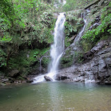
A very small waterfall at the Takazato River


View Map It! Okinawa in a larger map
River Trekking - Takazato River

     GPS
     LatitudeLongitude
     N 26 42.259E 128 10.185


River Trekking the Takazato River 


The Takazato River that borders Ogimi and Kunigami Village can be fun and enjoyable, and yet very challenging for even the most experienced nature hiker. If you thought river trekking to Fukugawa II was somewhat strenuous then Takazato will give you a real good workout. There are a lot more risks here however, and more caution is required. This can be rewarding and fun, but you have to respect nature and your limits. If you have poor agility and coordination, then you will have a tough time. Along the way, you will have to negotiate small boulders. And at times, in the interest of safety you may have to skirt the river via small trails off to the side that are often masked by thick vegetation.  The risk here then becomes snakes. It is highly recommended that you read all the guidelines below. This can be adventurous and exciting, but respect towards mother nature must have the highest priority.

Interesting things to see. Click on the photo album above to see the some of the natural beauties along the way. When you arrive at the parking area, you will see a small dam. It's an interesting setup and a good place to just relax if nothing else. Once you begin your journey, you will see a noticeably unique 'Gajimaru Tree'. Further down the river, you will see the 'Fern Arch', consisting of what appears to be two dying trees with an abundance of ferns that have taken over. You will also see many, many boulders with beautiful cascading water streams. The highlight of this journey is a small waterfall (1.5-2 meters high) that you see above that pours into a good size pool of water.

Starting Point. The start of the trail begins at the parking area behind the picnic tables. You will see a noticeable trail that takes you little higher up a hill. It takes you behind the dam.

Highlight/Turn-around Point. The highlight of this trip is a small pretty waterfall (1.5 - 2meters high) that goes into a large pool of water (above picture). This is about 1hr 30 minutes to 1hr 45 minutes away from the starting point. Further past this point are more rocks and boulders and the 'turn-around point' is at GPS N26 41.966 E128 10.328. Both are marked in the map above. You will notice on the map that a farm is about 300 meters due east of the turn-around point. It is not certain what is further upstream beyond the turn-around point.

Trekking Time: 1:30-145 minutes at a reasonable safe pace to the turn-around point.

Directions. The main turn-off is from Highway 58 just before the statue of the Yanbaru Kuina. From there, getting to the actual starting point may take some doing. Essentially, you are following the Takazato River on the south side. Study the map carefully. You will see another designated landmark of apartment buildings just before you go onto the dirt road leading you to the starting point.

GUIDELINES (PLEASE READ). 
The Guidelines are similar to that of going to Fukugawa II with a few exceptions. Because this trek is little more difficult please read through all the guidelines.
1. VERY IMPORTANT. This particular river trek is recommended only for those who have fairly good physical agility and coordination skills. Negotiating large boulders may be required at times. Recommended only for young adults and above.
2. VERY IMPORTANT. Plan on getting wet up to your knees. It will sometimes be safer just to walk in the river, rather than hopping and balancing yourself on the boulders & rocks just to keep dry. If the boulders are wet (& best to assume they will be), they will be slippery. Though this rule may seem trivial, it is a very important thing to remember. The biggest risk trekking along this stream is slipping and falling on the rocks.
3. DO NOT WEAR TENNIS SHOES!!! Tennis shoes offer no traction and will slip on these rocks. Wear something that has hard soles and has great traction on these kinds of surfaces. If you do not have hard soles you will 'feel' every step you take. And since you will be getting wet, thick heavy boots will only get heavier when soaked. You should wear something that is lighter, has good traction, but still gives you flexibility of movement. 
4. GUIDE STICK. It was not recommended for Fukugawa II that you do bring a guide stick, however, it will be needed here. Sometimes it will be safer to skirt the terrain just to avoid large boulders. You will see some trails that may have thick vegetation. You will need a guide stick to probe these areas and to knock down spider webs. When you are negotiating boulders however, you will have to set your guide stick aside to free your hands for climbing.
5. Never go alone. Have a buddy. For this particular river trek, the 'ideal' number is to have at least three (3) hiking buddies if you can, but optimally to have more than 3 due to the level of difficulty. If one gets hurt, then you have the option of leaving one with the injured while the other go gets some help. Cell phone reception is very difficult, if not non-existent in these areas. If you are a US Service Member, your nearest US Military Facility will be the Okuma Recreational Facility. It is recommended that everyone should have the number to this location should an emergency arise.
6. Tell someone where you will be river trekking at and leave them the GPS coordinate of the starting point. The starting point is N26 42.259, E128 10.185.
7. Wear something that is long sleeve and light (depending on the weather) for protection against the elements and bugs. Whether you trek on the river or skirt the landscape, you will hit spider web after spider web (summer or winter).
8. Wear a hat or beanie to keep warm and to protect yourself against the elements and bugs. You will run into many spider webs along the way (Do a 'spider check' with your buddy every now and then). A beanie does offer some bit of protection as a cushion in the event of a fall.
9. Bring some light hiking gloves for grip and protection. You may be required to grab roots, tree limbs, trees, rocks, dirt, etc. in order to negotiate terrain.
10. DO NOT WEAR SHORTS. Find something that you don't mind getting wet in and that offers protection against the elements. There 'will' be a few times you will be on your knees or on your rear end as you negotiate some of the terrain. Also you need to protect your legs from critters. You may want to bring some shorts if you want to take a dip in the water pool later. 
11. Apply the '3-Points of Contact Rule' when going over difficult terrain.
12. Maintain a low center of gravity when going over difficult terrain.
13. If something looks unsafe, then don't do it. Find another way to go around it or SIMPLY, DON'T DO IT. Don't try to be brave. 
14. Give yourself plenty of time AND TAKE YOUR TIME. NO NEED TO RUSH. But remember you have add time to get back (before dark!). Recommend you leave early morning time frame.
15. Bring a light backpack for food, water, toilet paper, flash light, survival kit, first aid kit, light rain coat, warming layers, etc.
16. USE THE BATHROOM BEFORE YOU GO! Making natural deposits of certain kind in the wild may not be fun for some.
17. You will get dirty. Bring a towel, extra socks, extra pair of shoes, shirt, pants, warming layers (Can leave in the car). 
18. Tuck in your shoe laces to prevent tripping.
19.Protect & secure items such as your wallet and cell phone from moisture and from getting soaked.
20.Don't try to be brave. Respect your limits and respect nature. 
21. You do not have to go all the way to the Highlight or Turn-around Point. You don't have to go far to enjoy some of the beauty along the Takazato river. Never feel pressured to continue on if you are fatigued or if it becomes too hazardous.
22. The Water Dam. The water dam area at the starting point has some deep areas. Parental supervision is required when small kids are in the area.

Sunday, March 11, 2012

"Kijoka Falls – Ogimi Village"

Kijoka Falls (Nana-taki - foreground)


View Map It! Okinawa in a larger map
Kijoka and Nana Taki

     GPS
     LatitudeLongitude
     N 26 42.125E 128 08.937


Kijoka Falls – Ogimi Village


Often referred to as just Kijoka-taki, this waterfall in the Kijoka district of Ogimi Village is broken up into two parts. The Kijoka residents call the smaller of the two waterfalls, Nana-Taki (foreground waterfall), and the much bigger of the two, Kijoka (background waterfall). Together, they make one beautiful couple and a wonderful scene. The location of Kijoka mimics that of its sister waterfall to the south, Todoroki of Nago City. Both are tucked away nice and neatly at the corner's edge of their respective towns, and both are relatively a short walking distance from the parking area.

Kijoka's beauty also rivals that of its sister, Fukugawa, also in Nago City. But Kijoka is unique in one respect. There is a Torii Gate at the entrance about 50 meters to its front, and to the right is an utaki (place of worship) for the local residents. The Kijoka Falls is a very peaceful place, and one of many waterfalls you should see during your stay here on Okinawa.

Author's note. Because Kijoka (and Nana) reside very close to a sacred area, one must conduct him or herself accordingly. Loud noise and 'energetic' behavior i.e. swimming, climbing around, shouting etc., that you could normally do at other waterfalls is probably not a great idea here. Initially, it is best to have the same mindset as if you were going into a temple, but one has to gauge the atmosphere to get a feel what is acceptable or not. As the saying goes, “When in Rome, do as the Romans do”.

Ceremonies. It is understood by the local community that visitors come here to see the Kijoka Falls, but if in the event there is some kind of worship or prayer ceremony in progress, you may want to consider coming back at another time — unless the local residents say it is okay to stay. Taking photos of any kind during prayer ceremonies is highly advised against unless given 'expressed' permission by the people involved. It perhaps... is best not even to ask, just better to come back at another time. This kind of visible restraint sometimes goes a long way in showing and winning respect.

Directions. Kijoka Falls is approximately 4km to the south of the Okuma Recreational Facility and near Highway 58. If driving north, you will notice a 'Y' fork off the 58. This is where your route starts. See blue route above. As soon as you turn right at the 'Y' fork, turn on the first right. If you go pass the 3-Story building with a large 'Family Mart' billboard on top (picture of this landmark is not available at the moment), then you have gone too far. After the right turn continue straight. The road will be tight. Look for a greyish building as a cue for the next turn-off. At this landmark, you will make a right. The road will narrow and you will see a small parking area to the right. If you go any further you will see the Torii Gate. Do not park in this area. It is too narrow.

Other waterfalls of Okinawa (沖 縄 滝)
Azaka Falls (Ogimi Village), Fukugawa Falls (Nago City), Meoto Falls (Higashi Village), Ogimi Waterfall (Ogimi Village), Taa Waterfall (Ogimi Village), Todoroki Waterfall (Nago City), River Trekking to a Nameless Waterfall (Nago City). (Aha and Hiji Falls not listed at the moment).

Sunday, February 26, 2012

"River Trekking to a Nameless Waterfall (Fukugawa II)"

A Nameless Waterfall (Fukugawa II)


View Map It! Okinawa in a larger map
River Trekking to a Nameless Waterfall (Fukugawa II)

     GPS
     LatitudeLongitude
     N 26 36.158E 128 03.376


River Trekking to a Nameless Waterfall (Fukugawa II)


Seeing one waterfall is great. Seeing another one up the stream makes it all the more enjoyable. At the moment, it is not known if the waterfall you see above has an official name. It sits along the same river stream that feeds its baby sister, Fukugawa Taki, roughly separated by a 45 minute hike along the stream. Hence, the momentary name we have given it is Fukugawa II. Your journey starts from the top of Fukugawa I. See article on "Fukugawa Falls" to learn how to get to Fukugawa.  

The journey to Fukugawa II is what makes it exciting. Just like the Taa Falls in Ogimi, you have to trek along the river to see it. However, Fukugawa II is not as easy to get to. You have to negotiate over more rock terrain to get further up stream. Rarely will you see any flat, soft areas to walk on. Because of its difficulty, it is highly recommended that only young adults and above go on this venture. But use your best judgment.

Despite, the laundry list of safety precautions below, you can have a safe and fun time. But you do have to be prepared. Again, approach this with a sense of humility and respect towards mother nature. Below are some tips to keep you safe. 

GUIDELINES (PLEASE READ). 
1. VERY IMPORTANT. Plan on getting wet up to your knees. The reason this is soo important is that it is sometimes safer just to walk in the river, rather than hopping and balancing yourself on the boulders & rocks just to keep dry. If the boulders are wet (& best to assume they will be), they will be slippery. Though this rule may seem trivial, it is the most important thing to remember. The biggest risk trekking along this stream is slipping and falling on the rocks. That is why this is Rule #1.
2. DO NOT WEAR TENNIS SHOES!!! Tennis shoes offer no traction and will slip on these rocks. Wear something that has hard soles and has great traction on these kinds of surfaces. If you do not have hard soles you will 'feel' every step you take. And since you will be getting wet, thick heavy boots will only get heavier when soaked. You should wear something that is lighter, has good traction, but still gives you flexibility of movement. 
3. Never go alone. Have a buddy. For this particular river trek, the 'ideal' number is to have at least three (3) hiking buddies if you can. If one gets hurt, then you have the option of leaving one with the injured while the other go gets some help. Cell phone reception is very difficult, if not non-existent in these areas.
4. Tell someone where you will be river trekking at and leave them the GPS coordinate of the starting point. Not everybody, to include Okinawans, will know of this particular waterfall. GPS to the starting point to both Fukugawa I and II is N26 36.488, E128 3.228.
5. Wear something that is long sleeve and light (depending on the weather) for protection against the elements and bugs. 
6. Wear a hat or beanie to keep warm and to protect yourself against the elements and bugs. You will run into many spider webs along the way (Do a 'spider check' with your buddy every now and then). A beanie does offer some bit of protection as a cushion in the event of a fall.
7. Bring some light hiking gloves for grip and protection. You may be required to grab roots, tree limbs, trees, rocks, dirt, etc. in order to negotiate terrain.
8. Highly recommend not wearing shorts. Find something that you don't mind getting wet in and that offers protection against the elements. There 'will' be a few times you will be on your knees or on your rear end as you negotiate some of the terrain. 
9. Apply the '3-Points of Contact Rule' when going over difficult terrain.
10. Maintain a low center of gravity when going over difficult terrain.
11. If something looks unsafe, then don't do it. Find another way to go around it or SIMPLY, DON'T DO IT. Don't try to be brave. Mother Nature will have the last say. 
12. Give yourself plenty of time AND TAKE YOUR TIME. NO NEED TO RUSH. But remember you have add time to get back (before dark!). Recommend you leave early morning time frame.
13. Bring a light backpack for food, water, toilet paper, flash light, survival kit, first aid kit, light rain coat, warming layers, etc.
14. USE THE BATHROOM BEFORE YOU GO! Making natural deposits of certain kind in the wild may not be fun for some.
15.  You will get dirty. Bring a towel, extra socks, extra pair of shoes, shirt, pants, warming layers (Can leave in the car). 
16. Guide Stick. Having a guide stick may end up being more of a hazard than a safety plus. You need your hands to be free to feel and grab. Just be alert when walking through vegetation and take it slow.
17. Skirting the Terrain Vs Walking in the Water. Skirting the terrain can be more of an impediment and little more dangerous. Again, assume on getting wet in order to negotiate terrain safely. Safety should be the considering factor on whatever you should try to do.
18. Tuck in your shoe laces to prevent tripping.
19. Protect & secure items such as your wallet and cell phone from moisture and from getting soaked. 
20. Don't try to be brave. Respect your limits and respect nature.

Beyond Fukugawa II. When you arrive to Fukugawa II, the question then becomes: is there anything worth seeing on top and beyond? The answer is: not really. Pictures have been provided in the photo album. The view from down below is impressive enough. Getting over Fukugawa II is a little more physical demanding and little more dangerous cause of the steepness. On top, there is a man-made bridge-like structure that holds irrigation pipes that feed out water (possibly out to a farm). For safety, try to avoid these man-made pipe bridges. There are small paths off to the side of these bridges (though narrow) that may offer passage assistance to the top. Use your best judgment. Safety First. Again, the view from down below is impressive enough.

Further down the stream is another man-made structure that appeared be a control valve station at one time. The river flattens out and narrows with several 'Y' forks streams along the way. Our turn-around point was at GPS coordinate N26 38.594 E128 51.834 (an estimated 1.5 kilometer distance from Fukugawa II). By the Google map, our turn-around point was roughly 300meters from the nearest road.

Destination Time. The time between Fukugawa I and II is roughly 45 minutes when going at a reasonable safe pace.

Other Waterfalls of Okinawa (沖 縄 滝). Azaka Falls (Ogimi Village), Fukugawa Falls (Nago City), Hira Falls, Meoto Falls (Higashi Village), Ogimi Waterfall (Ogimi Village), Taa Waterfall (Ogimi Village), Todoroki Waterfall (Nago City), Kijoka Falls, Nameless Waterfall (Kunigami)

Monday, February 13, 2012

"Meoto Falls (Tachigawa Waterfall)"

Meoto Falls


View Map It! Okinawa in a larger map
Meoto Falls

     GPS
     LatitudeLongitude
     N 26 37.851E 128 12.866


Meoto Falls (Tachigawa Waterfall)


In Higashi Village there is a waterfall that is referred to by the locals as the 'Married Couple's Waterfall'. It is Meoto-Taki (or Tachigawa Falls), which flows from the Tachigawa River. The Japanese word 'meoto' in English gives reference to a 'married couple'. The main highway goes right over it, and you wouldn't know it if you were going on a Sunday drive. The Meoto-Taki is unique in that it has two separate waterfalls in close proximity, each having its own pool of water. And being that there are two, this may be the reason for the metaphorical description.

The Meoto-Taki is unique in another sense, in that part of it (or maybe all of it) sits on private property. At least the main entrance to the waterfall is on private property. There is a cafe and a pension on the same grounds. The gentleman who owns the land welcomes visitors. On his own time he does custom wood work for inquiring customers. He doesn't speak much English, but that shouldn't stop you from meeting a new friend and practicing some Japanese. He understands that people come here to view the waterfall. He is a very friendly gentleman.

Hours. Because the entrance way and part of the waterfall sits on private property, there are set hours where you can visit. Hours are from 11am to 7pm. Closed on Wednesdays. Cafe: 098-043-2186.

How to go about visiting. Because the waterfall entrance does sit on private property, it does provide an odd situation for many, and maybe a little uneasiness about walking directly into someone's yard visiting a waterfall. Just to make you feel at ease, recommend you go ahead and ask one of the staff if it is okay to see the waterfall. They know that people come here to see without asking, but it doesn't hurt to ask and it shows good manners and a sign of respect.

Cafe. The cafe menu is currently in Japanese, but they do have cheese-cake, tea, and coffee. There is a terrace with a nice view of the ocean and a chance where you can relax as you absorb the fresh air. It is not a bad place to enjoy your cup of tea.

Going for a swim. The pools of water are deep enough where you can take a short swim on a hot day. Keep in mind, that other families come here and visit. Though they did say it was okay to swim, I would just ask beforehand as a sign of politeness. Otherwise, it might be equivalent to going into your neighbor's swimming pool without first asking permission.

Directions. Look for a sign with a coffee cup on it along Highway 70. Behind the sign is the parking lot for the cafe. On the opposite side, you will see a two story building and an entrance. This is where you go in. You will see a walkway that takes you down the waterfall. Just remember there are two. To get to the first one, you will see a wooden walk-way that takes you down to the first level. If you skip the wooden walk-way and continue on the pavement, you will go further down to the second waterfall.

Another View Point. If you were to go 100 meters pass the cafe along the main highway you will see a visitor's stopping area. To the right of that is a road that takes you to another viewing area of the ocean. You can walk down to the beach but the steps are very uneven and may have overgrowth along the way. Use caution if you decide to go down. It is a nice view of the ocean down below however. Note: You are not allowed to take anything from the beach or its waters at this location, this includes lobster or clams. You can scuba dive but cannot take anything from the ocean. Spear guns of any kind are not allowed. There will be a fine if caught. Fishing with a fishing pole is okay. 

Other Waterfalls of Okinawa (沖 縄 滝).
Azaka Falls, Fukugawa Falls, Hira Falls, Ogimi Waterfall, Taa Waterfall, Todoroki Waterfall, River Trekking to a Nameless Waterfall (Fukugawa II), Kijoka Falls, Nameless Waterfall (Kunigami).

Other Places of Interest Nearby. The Higashi Museum, The Sakishima Sappanwood Tree, The Azalea Festival (March Only).

Wednesday, January 25, 2012

"Fukugawa Falls"

Fukugawa Falls


View Map It! Okinawa in a larger map
Fukugawa Falls

     GPS
     LatitudeLongitude
     N 26 36.325E 128 03.420


Fukugawa Falls


Maybe one of the most beautiful places on Okinawa, this waterfall lies in the very remote part of Nago City. It is probably one of the least known waterfalls on Okinawa, but its beauty may surpass that of its elder siblings. You might consider this the baby sister of waterfalls. When you arrive, you will be mesmerized as soon as you step on the gravel trail. Beautiful tall ferns along the Nago landscape blanket the tree line. The adjacent stream flows quietly and gently over the river bed. And at last, there she is...flowing perfectly and harmoniously down the earth as if she was nestled in the arms of mother nature. She is immaculate in as many ways and yet by her humble stature, commands much respect. She is Fukugawa Falls.

Click the above photo album to see more photos of Fukugawa, Or click here.

Author's Note: No where is it written on how to conduct oneself when you arrive. But as a humble suggestion if you are going for the first time, I recommend going with a sense of humility and quietness as if you were entering a shrine. Part of the beauty of Fukugawa is listening and allowing the nature to speak to you; the soft wind, the swaying trees, and the sound of dripping water. Go as you please, but leave no trace behind – not even what would seem like a harmless etched inscription of a 'Jane and John Doe Were Here' at the wooded pavilion. This is a place where families and love ones, both foreigners and Okinawans, can enjoy the serenity and peace of the Ryukyu spirit together. Be modest in your conduct. Gauge the atmosphere. Loud noise may not be advisable at times since this can be a place of meditation for some.

Family Accessibility. Fukugawa is ideal for families and is something that all families should see together since this will be one moment they will treasure together. The trail is about a 15 minute walk, on mostly gravel and dirt. There are some places where you have to watch your step and may have to guide little children by hand (mainly when on the steps). There is one little area you have to cross that may get your shoes wet. On a normal day it should be about inch or so deep. Always be on the lookout for spider webs.

Getting to the Top. There is a trail that can take you to the top. It does not start at the base of the waterfall however. The trail starts from highest point the log steps reach – so you may have to backtrack if you are already at the waterfall. This picture shows portion of the trail branching from the steps (it is to the right). CAUTION: CLIMBING NOT RECOMMENDED FOR YOUNG CHILDREN. There are some areas where you can trip, fall, and tumble down if you have poor coordination skills. Once you are on top, use EXTREME CAUTION when approaching near the edge of the waterfall. The rocks are very slippery with little to grip. If you get too close and slip, you will have nothing to grab onto. You will fall...all the way down. Fukugawa is beautiful, but respect it and respect your limits.

The 'Tarzan Rope'. There is a small 'Tarzan Rope' to the left facing the waterfall but by the looks of it, it does not look sturdy enough to hold someone of average adult weight. Highly discourage any adults to use it. Use good judgment with your kids. The end result could be a broken tree in the pool of water.

Getting there. Study the map carefully and study the designated landmarks. Once you are on the blue route, go at a moderate safe speed so as not to pass any landmarks. There are two simple ways you can get to this waterfall. If you are familiar with the Haneji Dam/Highway 18 route, you can approach the starting point of the blue designated route from the southeast or you can come from Highway 58. Again depending on what direction you are coming from, look for these landmarks that are identified on the map; Statue of boy (turn-off on the 58), Radio Tower (Start of the Blue Route), Utaki at T-intersection (last major turn-off to the waterfall), Stone Marker (Halfway point to the waterfall). Near the end of the blue route you will approach a awkward T-intersection. Make a right here and about 20 meters to the left look for this chained off trail. This is where your trail starts. The sign says no vehicles allowed. You will have to park somewhere off to the side.

Hunting Season Advisement: CAUTION LEVEL: VERY LOW. Though not often known, Okinawa does have a hunting season (November 15-February 15).  You won't see any hunters near any public places, nor this waterfall. They usually go deep in the Nago Mountains away from any kind of population. This advisement  is for those who may wish to venture off later in the Nago Mountains after visiting Fukugawa. Only qualified and trained personnel are allowed to have such a hunter's license. It is mainly to hunt pest such as wild boar or other animals that have a negative effect on the land, crops, and other wildlife. Should you decide to go on a vehicle excursion in the Nago Mountains just be advised. They will be wearing bright orange, and sometimes organized in groups. There should be little to worry about if you stay on the blue route and known public areas, such as this waterfall.  Don't be surprised during this time though if you hear a shotgun go off in the distance. The Nago Mountains echo loud noises in this area.

Other waterfalls of Okinawa (沖 縄 滝).
Azaka Falls, Hira Falls, Meoto Falls, Ogimi Waterfall, Taa Waterfall, Todoroki Waterfall, Nameless Waterfall (Fukugawa II), Kijoka Falls, Nameless Waterfall (Kunigami Village).

Sunday, January 22, 2012

"The Golden Forest Utaki"


View Map It! Okinawa in a larger map
The Golden Forest Utaki

     GPS
     LatitudeLongitude
     N 26 37.391E 128 01.709


The Golden Forest Utaki – Nago City


This is the Golden Forest Utaki* in Nakaoshi of Nago City. It sits along one of Nago City's back roads near the base of the Nago Mountains. The name 'Golden Forest' harmoniously describes the immediate surrounding area. Off in the back you will see shades of gold tinted foliage and leaves. The stones in the foreground too are covered in tinted shades of gold. The inscription on the back of the main stone reads:

"This is a sacred utaki of Nakaoshi. Because of construction, part of the road now covers this utaki. This monument is built to pray for the safety of those who live in this region. 1986 February."

If you were to venture off to the tree line in the back you will eventually see a small rock-side waterfall. See photo album above. The entire area is very quiet and peaceful with a slight breeze swooshing through every now and then. 

Getting there. The are two simple ways you can get to this utaki. If you are familiar with the Haneji Dam/Highway 18 route, you can approach the blue designated route (in the map above) from the south. The landmark (radio tower) at the beginning of the blue route is your signal to turn. See post on Haneji Dam/Scenic Route 18 for more information about this route. The other means is through Highway 58. The landmark for the turn-off will be a small statue of a little boy. The utaki will be on your right as your are driving.

Parking. There are no designated parking areas near this utaki. You have to find a wide area in the road nearby to park safely. Be careful of on coming traffic. Because the utaki sits along a somewhat unknown backroad, vehicles tend travel little faster along this route.  

Hunting Season Advisement: Though not often known, Okinawa does have a hunting season (November 15-February 15). CAUTION LEVEL: VERY LOW You won't see any hunters near any public places, nor this utaki. They usually go deep in the Nago Mountains away from any kind of population. This advisement  is for those who may wish to venture off later in the Nago Mountains after visiting this utaki. Only qualified and trained personnel are allowed to have such a license. It is mainly to hunt pest such as wild boar or other animals that have a negative effect on the land, crops, and other wildlife. Should you decide to go on a vehicle excursion in the Nago Mountains just be advised. They will be wearing bright orange, and sometimes organized in groups. There should be little to worry about if you travel on public roads and to known public areas. 

Note1: *'Utaki' is a place of worship in Okinawa
Note2: Not all icons will appear on the same map from earlier post. For example, the Haneji Dam/Scenic Route 18 do not appear in the above map. Much like Google's search results, you have to click 'Next' or 'Prev' to see the next group of icons when you view the map in screen size. This is a Google protocol and is trying to be resolved.   

Wednesday, January 4, 2012

"The Taa Falls"

The Taa Waterfall


View Map It! Okinawa in a larger map
The Taa Waterfall

     GPS
     LatitudeLongitude
     N 26 38.048E 128 05.682


The Taa Falls


This is Taa-taki or the Taa Falls of Ogimi Village. It sits about 1.5 km south from its sister waterfall, Azaka. And unlike the cascading Azaka Falls, this waterfall drops straight roughly 50 meters below. To get an idea of the scope and size, click on this photograph with two people standing next to it. The Taa Falls is unique among the many known waterfalls here on Okinawa in one aspect; there are no man-made trails to get to it. You have to hike along (and sometimes) in the river to get there. With the exception of a few guide ropes along the way, you are on nature's terms. The walk is not that bad, only about 20-30 minutes depending on your pace. However, the walk does require some balance and coordination skills because of the sometimes awkward rock formations you must negotiate over. This venture is not recommended for very young children, but use good judgment as you see fit.

Once you get there you have no choice to embrace the beauty. Sit and relax with the family. On a hot summer day this place is ideal to cool off.

Getting to the top. PLEASE READ. There is a path that takes you to the top. It is to the left as you are facing the waterfall. There is makeshift rope to aid in you climbing up the slope. Once you get on top of the initial slope, there are two more trials that split but both get you to the outlet of the waterfall. One trail continues straight and down while the other to the right and up. RECOMMENDATION. I highly recommend you do not take the one that goes to the right. Although it seems closer to the outlet, it can be quite a task. There are many roots to trip on and can be very slippery, and in most cases, you are required by the assistance of a makeshift rope along the way. This route can be very painful on your hands as you balance your weight while holding the rope. I recommend taking the other route. You will only have to travel about 50 meters till you meet the river stream. Once you get on the stream, take a right and walk along the stream till you get to the outlet.

Advisement. PLEASE READ. Again, this hike is not recommended for very young children with low coordination skills. Use sound judgment. You will get wet. On a normal day of good weather, at most you can get wet up to your knees. Recommend having an extra pair of shoes and/or socks and a towel in the car. It is also recommended that you do not wear any soft sole shoes. If you do, you will feel every rock along the way as if you were walking barefoot. Tennis shoes should be find. Have shoes with good traction. If you already have some kind of hiking gloves, bring those as well so as to help you with grip and protection. During colder months, the gloves will also keep your hands warm. Recommend also bringing a small backpack to stuff food or other items like small towels or extra pair of clothing. You can take a short swim at this waterfall.

Directions. The route is almost identical on how you get to the Azaka Falls. If you drive north on Highway 58 just as you pass into Ogimi Village you will approach the Henan Bridge (there is no sign marker of the Henan Bridge in English characters on the southern side). But look for the bridge that has two Okinawan traditional flower hats known as 'hanagasa' on each side. You can either take the turn-off immediately before the bridge or immediately after the bridge. Continue along the road. About 1 km you will run into a 'Y' Fork in the road. Continue on the road to the right. At some point will see a very visible parking area next to the stream. You can park here. If you are facing the stream from the parking area. You hike to the left going up stream. There may be a sign hanging on the tree limb pointing you in the right direction.

Other Places of Interest Nearby: Azaka Falls.

Other Waterfalls of Okinawa (沖 縄 滝). Azaka Falls, Fukugawa Falls, Hira Falls, Meoto Falls, Ogimi Waterfall, Todoroki Waterfall, Nameless Waterfall (Fukugawa II), Kijoka Falls, Nameless Waterfall (Kunigami).