|
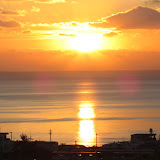
| Sunset viewed from Senaga Jima |
View Map It! Okinawa in a larger map
 |
| Mysticism and the Sunset at Senaga Jima |
GPS
| Latitude | Longitude |
| N 26 10.525 | E 127 38.534 |
Mysticism and the Sunset at Senaga Jima
Spending time on Senaga Jima during sunset is a very worthwhile moment, particularly if you are in a romantic mood. The picture above faces west towards the East China Sea. The light haze, acting as a natural filter, gave away the sun's well defined circular outline just as it was breaking through the horizon. Sunset viewing from Senaga Jima is a very popular activity with many Okinawans. But for some, the reasons may go a lot deeper. An Okinawan had once said that if someone had an abundance of misfortunes, a 'yuta' (an Okinawan mystic) would take that person, at his or her request, to Senaga Jima. During sunset, they would perform a ritual believing it will free the individual of his or her burdens.
This kind of ritual can be viewed as some kind of purification act to rid evil spirits believed to be the cause of such misfortunes. In Japanese this is referred to as 'yakubarai' (厄払い), a word meaning exorcism. Yakubarai could be done at a temple or at another sacred place under a direction of a spiritual mentor. If one's house was believed to have evil spirits, a 'yakubarai' ritual may be performed. These kinds of practices are not necessarily part of any organized religion. They can be performed by a self proclaimed 'spiritual enlighten' person. The yutas are a subject of great curiosity, and perhaps controversy as well. Many are treated with skepticism and yet there are many who are very highly regarded. Whatever the case may be, the yutas...or the belief in them, has to this day remain in part of Okinawa's folklore and mysticism.
This kind of ritual can be viewed as some kind of purification act to rid evil spirits believed to be the cause of such misfortunes. In Japanese this is referred to as 'yakubarai' (厄払い), a word meaning exorcism. Yakubarai could be done at a temple or at another sacred place under a direction of a spiritual mentor. If one's house was believed to have evil spirits, a 'yakubarai' ritual may be performed. These kinds of practices are not necessarily part of any organized religion. They can be performed by a self proclaimed 'spiritual enlighten' person. The yutas are a subject of great curiosity, and perhaps controversy as well. Many are treated with skepticism and yet there are many who are very highly regarded. Whatever the case may be, the yutas...or the belief in them, has to this day remain in part of Okinawa's folklore and mysticism.
The Mystery Island. The island seen in the background above is Maejima. It sits between Senaga Jima and Tokashiki Island, which has administrative control over Maejima. Maejima has a little interesting story of its own. It is largely uninhabited...with the exception of one family. It wasn't always that way. At one time it had a small population, close to 400 people. But hard times had forced the people to flee the island for a better life. According to the Ryukyu Shimpo, “The last four families went to live in Naha in February 1962 and Maejima Elementary and Secondary Schools were closed. With this the island became uninhabited”. A former resident, Fumio Nakamura, writes his account in his new book about the history of Maejima. In 2003, Mr. Nakamura decided to move back to Maejima with his family, and after 42 years, Maejima officially regained its inhabited status becoming the 40th inhabited island in the Ryukyu Archipelago. See article linked below by the Ryukyu Shimpo dated June 3rd 2012.
Traffic. Senaga Jima is not a difficult place to get to. However, if you are going to go to view the sunset, you need to give yourself plenty of time. Traffic is heavily congested during evening rush hour.
Directions. Travel south on Highway 331 past the Naha Airport. Study the map carefully. The main road to Senaga Jima branches off where Highway 331 splits. Make sure you take the 331 that veers west. You will see street signs directing you to Senaga Jima.
Source of information. Maejima: http://english.ryukyushimpo.jp/2012/06/10/7288/
Notes. 1. It is under the impression that most yutas are considered to be female.