Search Map It! Okinawa

Tuesday, June 26, 2012

"Mystery of the Bumagongen Shrine"

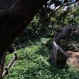
Steps leading to the Bumagongen Shrine


View Map It! Okinawa in a larger map
Bumagongen Shrine - Nago City

     GPS
     LatitudeLongitude
     N 26 36.431E 127 54.051


The Bumagongen Shrine – Nago City


It is quite possible to live on Okinawa for many, many years, drive along Highway 449 a hundred times, and still never notice this very well hidden elaborate and mysterious shrine. This sacred grove sits on a isolated hilltop near the Motobu and Nago border well camouflaged by an unusual surroundings of rock quarries and giant machines that mask what should be a very visible and conspicuous shrine seen from the highway. This is the mysterious Bumagongen Shrine – Its origin may be as puzzling as its place and location.

Information provided by the Nago City Museum did reveal that the shrine may have been built some time during the Meiji and Taisho Period (1868-1926). It was during this time that various industries had faltered and the shrine was believed to help provide prosperity and to bring life back to the community. Originally, the sacred ground was only one tsubo in size (equivalent to two tatami mats). Reconstruction from September 5th, 1925 to its completion over a year later on December 7th, 1926 expanded the shrine's area. Ironically, though the shrine was meant to bring prosperity, the community that once thrived in that area is no longer in existence, and any legends and stories about the origins of its enshrined 'kami' or god may have been lost with it.

The architectural style was considered unique for its time. Two masonry craftsmen from Ogimi Village was said to have assisted in its renovation. However, the list of donors that aided in its reconstruction can no longer be found. In 1985, the Bumagogen Shrine celebrated its 60th Anniversary of its reconstruction, and from all accounts, still stood as it did many decades ago.

The cave. The cave is presumably where a 'kami' or god is enshrined. It sits in the rear of the stone structure. It is fenced off and not permissible for entrance.

Directions. If you take Highway 449 along the coastline going north look for a large mill-like structure to your right (Landmark icon designated above). Take the first right after you pass this Landmark. From there you should be able to navigate your way to the shrine entrance. It is roughly 600 meters from Highway 449. The torii gate will also be visible from Highway 449 if you look behind and to the right of the mill.

Notes.
1. Meiji Period (1868-1912), Taisho Period (1912-1926)

Tuesday, June 19, 2012

"The Tomori Stone Lion"

The Tomori Stone Lion


View Map It! Okinawa in a larger map
The Tomori Stone Lion

     GPS
     LatitudeLongitude
     N 26 08.016E 127 43.461


The Tomori Stone Lion


Perhaps one of the most recognizable scenes from the Battle of Okinawa was a picture taken of the Tomori Stone Lion, a now famous hallmark figure of Okinawa History. The stone lion faces the Yaese Mountain ridge – still standing tall and strong as it has for centuries. According to Okinawa lore, its orientation is not by coincidence but rather a product of Feng Shui, which is an ancient Chinese art that studies the balance of nature and energy to help promote prosperity. Traditionally, the practice of Feng Shui has been used to determine the orientation of certain structures of significance. It is believed that the construction of the Tomori Stone Lion was consulted by a Feng Shui master and was erected to face the Yaese Mountain Ridge to prevent fires in that area (prior to, the Yaese ridge had had a series of fire incidences). Another belief was that it was to give strength to an Aji or Lord of the Yaese area. Its exact date of origin may still be a mystery, but it is said to be first mentioned in an article written in 1689.

According to a Japanese publication titled Okinawa Shisas (沖縄 シーサー, published 1982) a ceremony called the 'Tantoi' Festival was held prior to the war on September 9th of the Lunar Calendar, in which a young man would perform a dance around the Stone Lion. According to that same publication the ceremony is now held on October 1st and its purpose is still to prevent fires in the surrounding area.

Today, the Tomori Lion stands strong despite the visible wounds from the Battle of Okinawa. It is one of the last vestiges that remains intact from that era and serves as a testimony of the strength and resolve of the Okinawan people.

Notes.
1. Tomori Village was once known as Tomimori Village.
2. Though the publication did not specify, it is believed that the October 1st date is based on the Lunar Calendar. And because the publication was dated in 1982, it is not certain if the October 1st date is still the current ceremonial date.

Directions. The most straight forward route is to take Highway 58 into Naha City and then take Highway 329 going east. Next, go south on Highway 507. Then turn west on Highway 52 at the Highway 507/52 Intersection. Look for this Landmark store on the right hand side. Just before this store you will turn right. You will see signs that will lead you to Tomori Lion.

Note. Google Map has Highway 52 as Highway 15. There are no visible signs of Highway 15 on the ground. Furthermore, prior to the Highway 507/52 Intersection (just north of this intersection) you will see a sign pointing to the Tomori Lion. This route may get you more confused and lost. It is recommended you stay with the route designated above.

Source. Research at the Tomigusuku City Library, Japanese book titled Okinawa ShiShi Dogs (沖縄 シーサー) , Nagamine, dated Showa 57 (1982).

Other Related ArticlesThe Tomori Lion by Keith Graff, Then and Now Photos: The Stone Lion of Tomori, Okinawa by Michael Lynch.

Other places of interest nearby. Gangala.

Monday, June 11, 2012

"Sunabe Baba Park & Beach"

Beach near Sunabe Baba Park


View Map It! Okinawa in a larger map
Sunabe Baba Park & Beach

     GPS
     LatitudeLongitude
     N 26 20.028E 127 44.700


Sunabe Baba Park & Beach


A great outdoor combination, Sunabe Baba Park accommodates a nice mixture of recreational facilities, while being next to a very warm and relaxing beach. Here many families come to spend time with each other, whether it's playing at the park, spending some time in the sun, or strolling along the water's edge during low tide. Included at the park are sit down areas, playground equipment, a basketball court, and a skateboard park. A five minute walk from the park takes you to the local beach where you can just sit and enjoy the scenery. Below are basic guidelines from the Chatan Park management.

Rules & Regulation.
1. Please clean up after your pets. (Though not openly stated, recommend having leashes for your pets due to high volume of children in the area).
2. Barbeques are not allowed.
3. On weekdays, the skateboard park is open 3pm to 8pm. Holiday's and weekends is 9am to 20am.
4. Personnel utilizing the skateboard ring must wear a helmet before they can go inside.

Bathroom Facilities: Available.
Shaded Areas: Available, but limited.
Swimming: There are rocky shallow areas that may not be suitable for swimming.
Parking. Available. See green icon above. Limited during weekends & Holidays

Directions. The turn-off is on Highway 58, two traffic lights north of the Highway 23 & Highway 58 Intersection. See map above. Look for the street sign designated by the pink thumbtack above.

Other places of interest nearby. Kumaya Cave.

Tuesday, June 5, 2012

"Igei Beach, Kin Town"

Igei Beach, Kin Town


View Map It! Okinawa in a larger map
Igei Beach - Kin Town

     GPS
     LatitudeLongitude
     N 26 27.337E 127 52.800


Igei Beach, Kin Town


One of the nicest beaches you will find on the eastern side of Okinawa not belonging to a resort nor near a highly populated area resides at the southern end of Kin Town. It is Igei Beach. The white bleached sands and the beautiful blue ocean gives Igei Beach its gleaming luster. The beach stretches for about 1km north to south covered with soft white sand, and in between and at the bookends are several rock jetties for fishing or relaxing or both. There are two parking areas designated with the green icon above. Between the parking lots lies a grassy field for playing or other recreational activities. At the north end of Igei Beach is a swim net to keep out jelly fish and other dangerous sea life. See below for stated rules & regulations for Igei Beach.

Recommendations. At Igei Beach there are no shaded areas on the actual beach. It is recommended that you bring your own equipment for shading.

Direction. Igei Beach lies next to Highway 329 10 minutes north of Entrance/Exit 6 of the Okinawan Expressway.
Parking. There are two main designated parking areas at the north and south end. See green thumbtack icons above.
Bathroom facilites. Bathroom facilities are available at each parking lot.
Swim nets. A swim net for recreational swimming is located at the northern end of Igei Beach.

Main Beach Rules for Igei Beach (Signs/other rules are posted in Japanese and in English).
1. Please take all your trash with you. Do not bring glass containers or other breakables in the park.
2. Disorderly conduct or other acts that disturb other park users are prohibited.
3. Alcohol consumption, camping, as well as activities using fire such as BBQ, fire works, and bonfires are prohibited.
4. Do not disturb public peace by riding bicycles, motorcycles, and skateboards in the park area.
5. Use of power generators and floodlights are prohibited. Use of stereo, karaoke , or other noise disturbances is prohibited.
6. Please walk your pets on a leash and pick up after pet.