 |
| The Shark's Fin of Teniya, Nago City |
View Map It! Okinawa in a larger map
 |
| Chasing the Shark's Fin |
GPS
| Latitude | Longitude |
| N 26 33.016 | E 128 06.484 |
*GPS data is to the starting point
Chasing the Shark's Fin (Nago City)
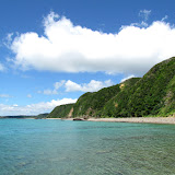
At different points along Highway 330 off the northeastern shores of Okinawa you may notice several shark fin-like rocky mounds near the coastline. One in particular stands prominently among them. This is the 'Shark's Fin' of Teniya near the northern border of Nago City. Naturally, some will be curious to know how they can get there for a closer view. To do that...you either have to travel by boat, kayak, charter a small plane, ride a glider, or by the most affordable means – on foot.
As you get closer to the Shark's Fin you have to scale small rocky cliffs or walk in waist high water to continue on the other side. Waters in these areas are somewhat shallow to a few hundred meters out. However, the closer you get to the Shark's Fin the rougher the water gets. But the Shark's Fin is not the only thing to see along the way, and you don't have to go all the way to have a good time. The scenery itself is breath taking.
Author's note. In fairness, the entire trek was not completed...meaning I did not go the Shark's Fin and then go all the way back where I started. I continued further to see what was on the other side in the next town. After 4 hours of the being in the relentless Okinawan summer heat, dehydrated, and exhausted from the journey, the thought of going all the way back was not exactly greeted with open arms. I was fortunate enough to meet a kind fisherman who would give me ride back. He laughed at the idea that I would walk this far in the first place.
Since I did not travel back the same way I came in I cannot give you a first hand account if the change in tides will have an effect on your return trip. As a precaution I would base your travels based on the tide information. The furthest you have to walk in the water is about 50-75 meters at about waist height in relatively calm waters.
Starting point. Your starting point begins at the beach parking area in Kayo designated by a Green Thumbtack in the map above. GPS coordinate above is to this area.
Timeline. Plan on 1hr and half to 2 hours getting to the Shark's Fin. Included in this time are your water breaks, photo breaks, bathroom breaks etc. Again you don't have to go all the way to the Shark's Fin to have a good time.
Places of interest along the way.
-Kayo Beach. If you are not interested in beach trekking, the beach at Kayo is just a nice and relaxing place to visit all together. The scenery is relaxing and peaceful since the waters here tend to be very, very calm. You will still be able to view the fin from a distance.
-Bonsai style tree. About 500 meters north from the starting point you will see a large mound with a very beautiful bonsai style-like tree on top. The tree from a distance looks like one big tree, but up close you will see that it is actually two large pine(?) trees next to each other. Being so exposed to the elements, it is a wonder how they survived through years and years of severe weather.
-Small Waterfall. The second estuary will lead you to a small waterfall. It is about a 20 minute hike along the stream. This can be a culminating point for your journey should you wish. The waterfall is small about 15 feet high with low volume of water gushing through it (depending on the season). The pool of water is nice if you just want to sit and cool off and can easily fit 6 people. You will see many spider webs along the way. The waterfall is at GPS N26 33.330 E128 7.466 and is marked by a Pink Balloon Icon on the map. Note. The creek bed leading away from the 1st and 3rd estuaries were not investigated.
-Unusual rock formations. Once you reach the Shark's Fin you will notice unusual rock patterns on the cliff-side. This was the only area along the trek with these unusual rock patterns of this nature (that I could tell) and it may say something of the unique geological history of this particular area.
-The Shark's Fin. At last, the Shark's Fin. At this point you have just traveled 3.5 Kilometers (2.12 miles). Congratulations!
Can you get to the Shark's Fin from the north? The answer is yes, and considerably takes a lot less (maybe 40 minutes) to get to your destination. However, the scenery along the way is not as impressive and there is one place you have no choice but to walk in the water up to middle-chest to shoulder height of water for about 30 meters depending on the tide as you are clinging to the rock side. The waters here are little stronger than the southern starting point.
Other Photos. Click here or the above photo album to see pictures taken up to the Shark's Fin.
Recommended Guidelines.
Fitness. Getting to the Shark's Fin requires a good level of physical fitness and physical agility. As mentioned above, the closer you get to the Shark's Fin you will have to scale over rocky terrain. Sometimes the safest way is to cling to the side and walk in the water. For the most part it should be knee to waist high water but this may vary depending on the tide. You can pretty much walk 90% of the way on the beach alone. Most of the climbing is manageable, but one slip can lead to a bad day.
Bring plenty of water. Having plenty of water is a must, even if it is not too hot outside.
Nourishments. Recommend a small backpack with snacks (waterproofed of course).
Plan on getting wet. Waterproofing certain valuables is highly highly recommended (i.e. cell phone, camera).
Shade. Cover up with a hat or towel particularly if you are going to be in the hot sun. There are very few areas along the way for shade.
Slipping. Rocks along the coral cliffs can be very, very slippery. Recommend something other than tennis shoes that have good traction and you don't might getting wet. Recommend hiking gloves.
Bring a few buddies with you.
Center of gravity. Use three points of contact and keep low center of gravity. Take nothing for granted on these rocks.
Mapping Points. Other LandMarks you will see during your trek have been posted on the map above.
Directions. The starting point (Kayo Beach) is right off Highway 330. Look for this Landmark on the right-hand side as you are traveling north. It will be next to an old school. It is about 30 minutes from the time you leave Highway 329 onto Highway 330.
No comments:
Post a Comment