Search Map It! Okinawa

Tuesday, May 29, 2012

"Tsuken Jima"

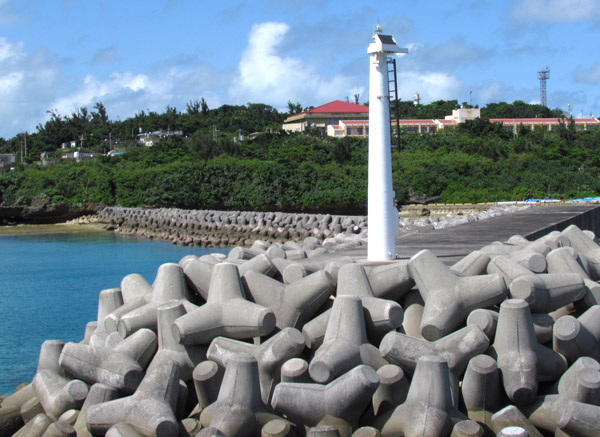
A light beacon on Tsuken Jima


View Map It! Okinawa in a larger map
Tsuken Jima
     GPS
     LatitudeLongitude
     N 26 18.396E 127 55.360
        *GPS to Heshikiya Port


Tsuken Jima


Known for its carrot fields, Tsuken Jima (or Tsuken Island) sits off the coast of Okinawa proper, southeast of the Katsuren Pennisula. The entire island can be pretty much seen in one day on foot, and makes for a great one-day excursion off-island. If it is your first time trip to Tsuken, recommend that your start on the south western side of the island first. It is here where the 'Tsuken Trail' begins. From there you can trek north, clockwise to the other side of the island and make your way back south.

The Tsuken Trail. The Tsuken Trail is mostly a paved walkway that begins on the southwestern end of the island. Near the beginning of the trail (see map icon above) there is a 'Peace Pole' and the Hotoga Spring. The 'Peace Pole' can be visible on the boat ride coming in. As you are searching for this trail, it is quite likely that you will end up finding part of the trail north of the starting point. If that is the case just make your way south to see the Peace Pole and the Hotoga Spring.

Continuing North. Along the trail you will see several utaki's (places of worship) and side trails that take you higher up on the ridge. One of the side trails going up the ridge will take you to an Observatory shaped like a carrot, where you can see a panoramic view of the Tsuken Jima. If you were to continue on the coast along the trail you will see the Kubougusuku Ruins. The paved trail ends at a resort facility and Tsuken Beach and then the trail becomes a dirt trail that continues north along the Toumaihama coastline. Not far on this trail is the 'Naka no Utaki' which is sacred to the people of Tsuken Jima. There is a historical sign translated in English on location. The Utaki is said to also be the burial tomb of a person referred to as Kishabashii, who is considered the “founder” of Tsuken Jima. He was originally from Kishaba Village in Nakagusuku and helped establish a community here on Tsuken Jima long ago.

Northern tip. The northern portion you will see the Yajirihama Coast and a view of another uninhabited island, Afuiwa Island.

Pēkū Gama (ペークー ガマ). Along the north eastern side is a small cave that is also a place of worship. This is called Pēkū Gama or the Pēkū Cave. To find this cave you have to navigate your way to the northern most 4-way 'paved road' intersection on the eastern side. From there go east on the the paved road till you see this sign marker which says Pēkū Gama 300m in Katakana (ペークー ガマ). Follow the arrow and the trail. There are some side trails but eventually you will see this small cave opening. Along this trail, you may see some large land crabs, some with large pinchers – and if you are lucky, even a coconut crab. In the event that you do see a coconut crab, just be aware that they can grow very large and their pinchers are known to cut off coconuts/screw pines from trees. They are very strong. Also because of the intense moisture in this area, there are a relentless amount of mosquitoes at this location. For safety and cultural sensitivities, it is recommended that the cave not be entered. 

Please see photo album for more things to see at Tsuken Jima.

What to bring. Umbrella for shade and to remove spider webs, mosquito repellant, hat, neck towel, sun screen, hiking gloves for protection, small backpack, bring your own food and water for the stay (you will not see many stores and open restaurants along your walk). If you don't mind the heat, then wear some comfortable pants and long sleeves. This depends if you decide to venture in densely vegetated areas where you will see many mosquitoes, bugs, spiders etc. If you going there to fish or swim than plan accordingly.

GETTING THERE.
Heshikiya Port. Heshikiya Port is your point of depature. It is near the tip of the Katsuren Pennisula on the northside (see map icon above). There are three boats that alternate their voyage to Tsuken Jima (Tokiyo3, Kugani3, Ferry Kugani). Bringing a car is not necessary, but if you wish to take your car then it is recommended that you call in advance to ensure you know the correct time for the large ferry (Ferry Kugani) boat schedule. Reservations may be required. Heshikiya Port Phone Number: 098 978 1100

Boat Schedule.
Leaving Heshikiya Port: 730am, 9am, 11am, 2pm, 5pm.
Leaving Tsuken Jima: 8am, 10am, 12pm, 3pm, 6pm (530pm 10/1-3/31).
Schedule subject to change. Call in advance.

Car Transportation. Fee is based on vehicle length size. Prices subject to change. Call in advance. Price range: 4,770 Yen to 12,690 Yen.

Bike rentals. There is a small bike rental office behind the Tsuken Port. 500 Yen all day. Phone number 098 978 4029 or cell phone 090 2507 1611. Office personnel may not be immediately available and a phone call may be required to contact them. Note. If you decide to rent a bike and take the Tsuken Trail you may be required to walk your bike through lot of areas.

Ticket Price. You can buy a round-trip ticket but consider buying a one-way ticket if you are not sure what return trip you plan on making. Round-trip tickets will end up being slightly less. Prices will vary on which boat you take. Prices subject to change.

One-way ticket:  from 630-780 Yen for adults, to 320-390 Yen for children.
Round-trip tickets: from 1200-1490 Yen for adult, to 610-750 forYen children.

Heshikiya Port Phone Number: 098 978 1100

Wednesday, May 23, 2012

"The Benoki Utaki"

The Benoki Utaki


View Map It! Okinawa in a larger map
The Benoki Utaki


     GPS
     LatitudeLongitude
     N 26 47.336E 128 14.837


The Benoki Utaki - Kunigami Village


A small rustic-like wooden utaki* sits up in the forest hills of Benoki in Kunigami Village. It's not your typical style that is usually found in most parts of Okinawa where large stones and concrete slabs make up the majority of the composition. What also makes this utaki stand apart from others is that it has a large Torii Gate made of natural log wood standing at the entrance. Most Torii's found on Okinawa are made of fabricated material or concrete.

Perhaps there is a reason for this forest-style design. One of the residents of Benoki had said long ago, the men of Benoki used to go up in the hills to cut 'log wood' for day-to-day living material. The sacred grounds was used to pray for safety as they ventured up the 'forest' hills. Today, the utaki is used to give thanks and pray for good fortune and prosperity. He had also mentioned that the origins of the sacred area date back around the time of the Okinawan War. It is also important to note that the Torii Gate is an adaption originating from Mainland, Japan. 

The Benoki Utaki sits along the a stream that originates from the Benoki Dam not too far up the road. There is a path from the utaki that takes you down to the one of the bends in the river. The Benoki Dam Park appears to be largely unused. However, they do have an interesting set of Constellation Charts for a night time getaway on a clear night. If you are staying a few nights at the Okuma Recreational Facility then this might be an option for you and the family on a night time excursion.

Directions. The main turn-off is off of Highway 58. The LandMark Icon will be a Silo-like structure. The road will zig-zag up the hills and you will see the wooden Torii next to a small concrete fenced off building. If you were to go further up the road, you will run into the Benoki Dam.

*Utaki - Place of Worship

Wednesday, May 16, 2012

"River Trekking the Takazato River"

A very small waterfall at the Takazato River


View Map It! Okinawa in a larger map
River Trekking - Takazato River

     GPS
     LatitudeLongitude
     N 26 42.259E 128 10.185


River Trekking the Takazato River 


The Takazato River that borders Ogimi and Kunigami Village can be fun and enjoyable, and yet very challenging for even the most experienced nature hiker. If you thought river trekking to Fukugawa II was somewhat strenuous then Takazato will give you a real good workout. There are a lot more risks here however, and more caution is required. This can be rewarding and fun, but you have to respect nature and your limits. If you have poor agility and coordination, then you will have a tough time. Along the way, you will have to negotiate small boulders. And at times, in the interest of safety you may have to skirt the river via small trails off to the side that are often masked by thick vegetation.  The risk here then becomes snakes. It is highly recommended that you read all the guidelines below. This can be adventurous and exciting, but respect towards mother nature must have the highest priority.

Interesting things to see. Click on the photo album above to see the some of the natural beauties along the way. When you arrive at the parking area, you will see a small dam. It's an interesting setup and a good place to just relax if nothing else. Once you begin your journey, you will see a noticeably unique 'Gajimaru Tree'. Further down the river, you will see the 'Fern Arch', consisting of what appears to be two dying trees with an abundance of ferns that have taken over. You will also see many, many boulders with beautiful cascading water streams. The highlight of this journey is a small waterfall (1.5-2 meters high) that you see above that pours into a good size pool of water.

Starting Point. The start of the trail begins at the parking area behind the picnic tables. You will see a noticeable trail that takes you little higher up a hill. It takes you behind the dam.

Highlight/Turn-around Point. The highlight of this trip is a small pretty waterfall (1.5 - 2meters high) that goes into a large pool of water (above picture). This is about 1hr 30 minutes to 1hr 45 minutes away from the starting point. Further past this point are more rocks and boulders and the 'turn-around point' is at GPS N26 41.966 E128 10.328. Both are marked in the map above. You will notice on the map that a farm is about 300 meters due east of the turn-around point. It is not certain what is further upstream beyond the turn-around point.

Trekking Time: 1:30-145 minutes at a reasonable safe pace to the turn-around point.

Directions. The main turn-off is from Highway 58 just before the statue of the Yanbaru Kuina. From there, getting to the actual starting point may take some doing. Essentially, you are following the Takazato River on the south side. Study the map carefully. You will see another designated landmark of apartment buildings just before you go onto the dirt road leading you to the starting point.

GUIDELINES (PLEASE READ). 
The Guidelines are similar to that of going to Fukugawa II with a few exceptions. Because this trek is little more difficult please read through all the guidelines.
1. VERY IMPORTANT. This particular river trek is recommended only for those who have fairly good physical agility and coordination skills. Negotiating large boulders may be required at times. Recommended only for young adults and above.
2. VERY IMPORTANT. Plan on getting wet up to your knees. It will sometimes be safer just to walk in the river, rather than hopping and balancing yourself on the boulders & rocks just to keep dry. If the boulders are wet (& best to assume they will be), they will be slippery. Though this rule may seem trivial, it is a very important thing to remember. The biggest risk trekking along this stream is slipping and falling on the rocks.
3. DO NOT WEAR TENNIS SHOES!!! Tennis shoes offer no traction and will slip on these rocks. Wear something that has hard soles and has great traction on these kinds of surfaces. If you do not have hard soles you will 'feel' every step you take. And since you will be getting wet, thick heavy boots will only get heavier when soaked. You should wear something that is lighter, has good traction, but still gives you flexibility of movement. 
4. GUIDE STICK. It was not recommended for Fukugawa II that you do bring a guide stick, however, it will be needed here. Sometimes it will be safer to skirt the terrain just to avoid large boulders. You will see some trails that may have thick vegetation. You will need a guide stick to probe these areas and to knock down spider webs. When you are negotiating boulders however, you will have to set your guide stick aside to free your hands for climbing.
5. Never go alone. Have a buddy. For this particular river trek, the 'ideal' number is to have at least three (3) hiking buddies if you can, but optimally to have more than 3 due to the level of difficulty. If one gets hurt, then you have the option of leaving one with the injured while the other go gets some help. Cell phone reception is very difficult, if not non-existent in these areas. If you are a US Service Member, your nearest US Military Facility will be the Okuma Recreational Facility. It is recommended that everyone should have the number to this location should an emergency arise.
6. Tell someone where you will be river trekking at and leave them the GPS coordinate of the starting point. The starting point is N26 42.259, E128 10.185.
7. Wear something that is long sleeve and light (depending on the weather) for protection against the elements and bugs. Whether you trek on the river or skirt the landscape, you will hit spider web after spider web (summer or winter).
8. Wear a hat or beanie to keep warm and to protect yourself against the elements and bugs. You will run into many spider webs along the way (Do a 'spider check' with your buddy every now and then). A beanie does offer some bit of protection as a cushion in the event of a fall.
9. Bring some light hiking gloves for grip and protection. You may be required to grab roots, tree limbs, trees, rocks, dirt, etc. in order to negotiate terrain.
10. DO NOT WEAR SHORTS. Find something that you don't mind getting wet in and that offers protection against the elements. There 'will' be a few times you will be on your knees or on your rear end as you negotiate some of the terrain. Also you need to protect your legs from critters. You may want to bring some shorts if you want to take a dip in the water pool later. 
11. Apply the '3-Points of Contact Rule' when going over difficult terrain.
12. Maintain a low center of gravity when going over difficult terrain.
13. If something looks unsafe, then don't do it. Find another way to go around it or SIMPLY, DON'T DO IT. Don't try to be brave. 
14. Give yourself plenty of time AND TAKE YOUR TIME. NO NEED TO RUSH. But remember you have add time to get back (before dark!). Recommend you leave early morning time frame.
15. Bring a light backpack for food, water, toilet paper, flash light, survival kit, first aid kit, light rain coat, warming layers, etc.
16. USE THE BATHROOM BEFORE YOU GO! Making natural deposits of certain kind in the wild may not be fun for some.
17. You will get dirty. Bring a towel, extra socks, extra pair of shoes, shirt, pants, warming layers (Can leave in the car). 
18. Tuck in your shoe laces to prevent tripping.
19.Protect & secure items such as your wallet and cell phone from moisture and from getting soaked.
20.Don't try to be brave. Respect your limits and respect nature. 
21. You do not have to go all the way to the Highlight or Turn-around Point. You don't have to go far to enjoy some of the beauty along the Takazato river. Never feel pressured to continue on if you are fatigued or if it becomes too hazardous.
22. The Water Dam. The water dam area at the starting point has some deep areas. Parental supervision is required when small kids are in the area.

Wednesday, May 9, 2012

"Modelers Core Hobby Shop - Okinawa City"

Inside the Modelers Core Hobby Shop


View Map It! Okinawa in a larger map
Modelers Core - Okinawa City

     GPS
     LatitudeLongitude
     N 26 20.052E 127 48.127


Modelers Core Hobby Shop - Okinawa City


If you are a toy model enthusiast then Modelers Core in Okinawa City may have what you are looking for. They have an assortment of toy models ranging from air planes, cars, motorcycles, and military vehicles. However, their most prized possession is from one of Japan's most notable anime series, Gundam – a futuristic sci-fiction cartoon where human civilization is at war and mechanized robots are the means to an end. If you are into Japanese-style models then this is the place to check out. The store also carries other model accessories and has a large selection of toy model paint to meet all your model needs. 

Hours. 11am-8pm (Closed Thursday). Open during Holidays.
Telephone. 098 933 1774
Website. Website currently not available
Currency. Yen only.
Credit Card. Visa, MasterCard, Discover
Language. Japanese/Limited English.
Product Type. Toy Models, Toy Model Accessories, model paint. Remote Control vehicles not sold here.

Parking. There are two designated parking spot directly in front of the store. You will see two parking stalls. Parking stalls are parallel to the store (not perpendicular or angular). 

Directions. The store is located a few buildings southeast from the Okinawa City Police Station (near the Koza Music Town Building Intersection - Route 330/Route 20 Intersection). It sits along the same road that takes you to Kadena Air Station Gate 2 if you are going west. 

Other hobby stores in Okinawa. Yonkudou (Okinawa City), R/C Paradise (Kadena)

Wednesday, May 2, 2012

"Off The Beaten Path - Hamahiga"

Cliff at Hamahiga Island


View Map It! Okinawa in a larger map
Off the Beaten Path - Hamahiga

     GPS
     LatitudeLongitude
     N 26 19.389E 127 57.089


Off The Beaten Path - Hamahiga


If you happen to be at the beach at Hamahiga Island and like little side ventures while you're there, then there is a small off-the-beaten path that you may like which takes you further south on the western side of the island. If you wanted to walk a family pet, or just like to take a 45 minute round-trip stroll, then this off-the-beaten path isn't soo bad. Along the way you will see a few farms off to the side and a few little interesting coral rock formations. A few fisherman come here every now and then to get away in their own little hide-away in search for the 'big catch'. And if you like taking pictures of butterflies, then you have plenty to keep you occupied. They saturate the flowers along the trail non-stop. Bring a friend, camera, and a bento lunch. You may want to stop for awhile as you soak in the sun. At the end, you will get closer and closer to a very commanding looking cliff-side.

What to bring. Umbrella for shade, bug repellant, sun lotion, water, camera.

Where the path begins. The path starts at the balloon icon you see in the map. It sits next to the southern end of the parking lot. You will notice a make-shift gate prevent cars to go through. This is where you cross.

Warning. As you get closer and closer to the cliff-side you may be tempted to climb up some large coral rocks. These are highly dangerous for climbing. They are not sturdy and have jagged edges which can easily cut through skin.

Other places of interest nearby. Agari no Utaki, Hamahiga Beach, Amamichu's Grave, Shirumichu, The Gateway.